Property Record
1831 Brian Dr Ne, Conover, NC 28613
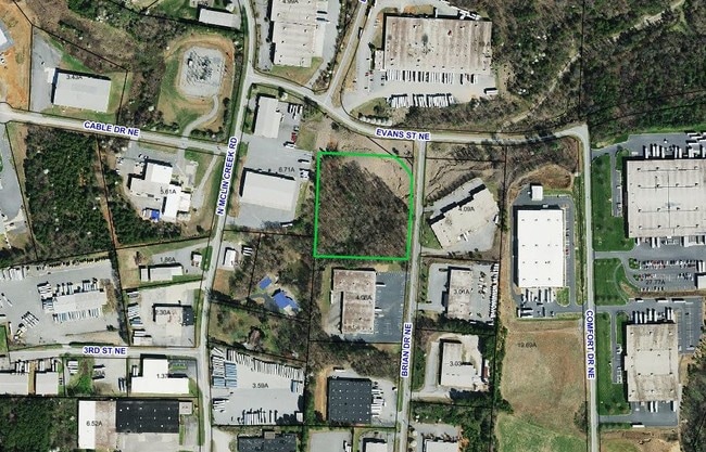

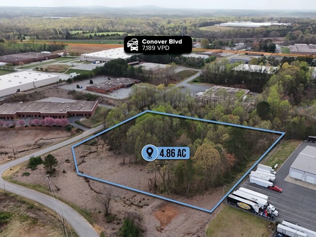
This Property Is For Sale
Property Detail
1831 Brian Dr Ne
Hickory-Lenoir-Morganton, NC
LOT 9 PLAT 23-56
3751051974610000
CATAWBA
Vacantlandnec
North Carolina
M-1
9
B and X Area of moderate flood hazard, usually the area between the limits of the 100-year and 500-year floods.
4.86 AC
2024
Catawba County
2025
Charlotte
010102
NEARBY LISTINGS FOR SALE OR LEASE
DEMOGRAPHICS near 1831 Brian Dr Ne
1 mile
3 mile
5 mile
2025 Total Population
793
16,880
40,133
2030 Population
821
17,441
41,509
Pop Growth 2025-2030
+ 3.53%
+ 3.32%
+ 3.43%
Average Age
44
42
41
2025 Total Households
327
6,753
15,837
HH Growth 2025-2030
+ 3.67%
+ 3.38%
+ 3.53%
Median Household Inc
$59,347
$54,054
$56,957
Avg Household Size
2.40
2.40
2.50
2025 Avg HH Vehicles
2.00
2.00
2.00
Median Home Value
$269,230
$247,754
$231,024
Median Year Built
1988
1987
1986
Nearby Places
Map Layers
Map Styles
 Street
 Aerial
Layers
 Traffic
 Biking
Places
Listings with unknown addresses are not visible on the map
- Restaurants
- Banks
- Shops
- Fitness
- Groceries
PUBLIC TRANSPORTATION
AIRPORT
Concord-Padgett Regional
Drive
Walk
Distance
Concord-Padgett Regional
67 min
49.4 mi
Nearby Properties
Address
Land Use
TOTAL SIZE
Lot Size
Zoning
Address
Land Use
TOTAL SIZE
Lot Size
Zoning
502,665 SF
53.28 AC
EM-1-CD
Address
Land Use
TOTAL SIZE
Lot Size
Zoning
368,024 SF
69.40 AC
M-1
Address
Land Use
TOTAL SIZE
Lot Size
Zoning
7,684 SF
11.85 AC
R-20-CD
Address
Land Use
TOTAL SIZE
Lot Size
Zoning
157,777 SF
25.42 AC
M-1
Address
Land Use
TOTAL SIZE
Lot Size
Zoning
101,781 SF
25.77 AC
M-1
Address
Land Use
TOTAL SIZE
Lot Size
Zoning
301,737 SF
45.71 AC
M-1
Address
Land Use
TOTAL SIZE
Lot Size
Zoning
67,806 SF
27.40 AC
M-1
Address
Land Use
TOTAL SIZE
Lot Size
Zoning
82,274 SF
19.77 AC
M-1-CD
Address
Land Use
TOTAL SIZE
Lot Size
Zoning
217,586 SF
28.33 AC
CC-CD
Address
Land Use
TOTAL SIZE
Lot Size
Zoning
398,044 SF
17.89 AC
M-1
Address
Land Use
TOTAL SIZE
Lot Size
Zoning
30.63 AC
R-20
Address
Land Use
TOTAL SIZE
Lot Size
Zoning
4,700 SF
34.87 AC
COI
Address
Land Use
TOTAL SIZE
Lot Size
Zoning
150,498 SF
11.27 AC
M-1
Address
Land Use
TOTAL SIZE
Lot Size
Zoning
23,646 SF
79.60 AC
M-1
Address
Land Use
TOTAL SIZE
Lot Size
Zoning
9,064 SF
4.59 AC
B-2-CD
Address
Land Use
TOTAL SIZE
Lot Size
Zoning
283,942 SF
26.59 AC
M-1
Address
Land Use
TOTAL SIZE
Lot Size
Zoning
270,125 SF
19.98 AC
EM-1
Address
Land Use
TOTAL SIZE
Lot Size
Zoning
226,704 SF
24.60 AC
EM-1
Address
Land Use
TOTAL SIZE
Lot Size
Zoning
155,824 SF
27.77 AC
M-1
Address
Land Use
TOTAL SIZE
Lot Size
Zoning
67,085 SF
15.80 AC
PD-SC-M
Address
Land Use
TOTAL SIZE
Lot Size
Zoning
14,702 SF
363.28 AC
R-20
Address
Land Use
TOTAL SIZE
Lot Size
Zoning
47,889 SF
6.95 AC
M-1
Address
Land Use
TOTAL SIZE
Lot Size
Zoning
213,422 SF
33.51 AC
M-1
Address
Land Use
TOTAL SIZE
Lot Size
Zoning
637,521 SF
87.22 AC
M-1
Address
Land Use
TOTAL SIZE
Lot Size
Zoning
20.90 AC
M-1
Address
Land Use
TOTAL SIZE
Lot Size
Zoning
318,757 SF
23.50 AC
M-1
Address
Land Use
TOTAL SIZE
Lot Size
Zoning
234,094 SF
15.22 AC
EM-1
Address
Land Use
TOTAL SIZE
Lot Size
Zoning
156,161 SF
17.22 AC
M-1
Address
Land Use
TOTAL SIZE
Lot Size
Zoning
14.87 AC
B-2
Address
Land Use
TOTAL SIZE
Lot Size
Zoning
206,696 SF
10.24 AC
M-1
The World's #1 Commercial Real Estate Marketplace
Connect with us
© 2026 CoStar Group
The information above has been obtained from sources believed reliable. While we do not doubt its accuracy we have not verified it and make no guarantee, warranty or representation about it. It is your responsibility to independently confirm its accuracy and completeness. Any projections, opinions, assumptions, or estimates used are for example only and do not represent the current or future performance of the property. The value of this transaction to you depends on tax and other factors which should be evaluated by your tax, financial, and legal advisors. You and your advisors should conduct a careful, independent investigation of the property to determine to your satisfaction the suitability of the property for your needs.