Property Record
18310 W Willis Rd, Goodyear, AZ 85338
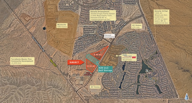

Current Lease Availabilities
Property Detail
18310 W Willis Rd
Phoenix-Mesa-Chandler, AZ
SELF STORAGE WILLIS AND RAINBOW VALLEY MLD MCR 1814-49
400-58-070R
MARICOPA
Commercialacreage
Arizona
PAD
2
AE The base floodplain where base flood elevations are provided. AE Zones are now used on new format FIRMs instead of A1-A30 Zones.
8.69 AC
2025
Southwest Outlying
2025
Phoenix
723311
NEARBY LISTINGS FOR SALE OR LEASE
-
-
View all Goodyear listings for lease on LoopNet.com
DEMOGRAPHICS near 18310 W Willis Rd
1 mile
3 mile
5 mile
2025 Total Population
3,884
12,302
22,164
2030 Population
4,153
13,079
23,478
Pop Growth 2025-2030
+ 6.93%
+ 6.32%
+ 5.93%
Average Age
54
46
44
2025 Total Households
1,680
4,611
7,902
HH Growth 2025-2030
+ 7.02%
+ 6.44%
+ 6.11%
Median Household Inc
$111,835
$122,151
$119,700
Avg Household Size
2.30
2.70
2.80
2025 Avg HH Vehicles
2.00
2.00
2.00
Median Home Value
$495,058
$496,211
$482,461
Median Year Built
2011
2010
2007
Nearby Places
Map Layers
Map Styles
 Street
 Aerial
Layers
 Traffic
 Biking
Places
Listings with unknown addresses are not visible on the map
- Restaurants
- Banks
- Shops
- Fitness
- Groceries
PUBLIC TRANSPORTATION
AIRPORT
Phoenix Sky Harbor International
Drive
Walk
Distance
Phoenix Sky Harbor International
52 min
36.0 mi
Freight Ports
Port of San Diego
Drive
Walk
Distance
Port of San Diego
380 min
335.1 mi
Nearby Properties
Address
Land Use
TOTAL SIZE
Lot Size
Zoning
Address
Land Use
TOTAL SIZE
Lot Size
Zoning
80.90 AC
PAD
Address
Land Use
TOTAL SIZE
Lot Size
Zoning
249,688 SF
44.52 AC
PF
Address
Land Use
TOTAL SIZE
Lot Size
Zoning
75,779 SF
15.16 AC
PAD
Address
Land Use
TOTAL SIZE
Lot Size
Zoning
48.24 AC
R-43
Address
Land Use
TOTAL SIZE
Lot Size
Zoning
3,955 SF
117 AC
PAD
Address
Land Use
TOTAL SIZE
Lot Size
Zoning
11,573 SF
4.05 AC
PAD
Address
Land Use
TOTAL SIZE
Lot Size
Zoning
25.48 AC
R-43
Address
Land Use
TOTAL SIZE
Lot Size
Zoning
22,896 SF
17.79 AC
R-43
Address
Land Use
TOTAL SIZE
Lot Size
Zoning
25,735 SF
68.61 AC
R-43
Address
Land Use
TOTAL SIZE
Lot Size
Zoning
0.25 AC
PAD
Address
Land Use
TOTAL SIZE
Lot Size
Zoning
1.29 AC
Address
Land Use
TOTAL SIZE
Lot Size
Zoning
1.23 AC
Address
Land Use
TOTAL SIZE
Lot Size
Zoning
1.23 AC
Address
Land Use
TOTAL SIZE
Lot Size
Zoning
1.23 AC
Address
Land Use
TOTAL SIZE
Lot Size
Zoning
288 SF
33.42 AC
AG
Address
Land Use
TOTAL SIZE
Lot Size
Zoning
1,740 SF
4.49 AC
PF
Address
Land Use
TOTAL SIZE
Lot Size
Zoning
1,140 SF
5.52 AC
R135
Address
Land Use
TOTAL SIZE
Lot Size
Zoning
37.10 AC
PAD
Address
Land Use
TOTAL SIZE
Lot Size
Zoning
8,050 SF
15.11 AC
PAD
The World's #1 Commercial Real Estate Marketplace
Connect with us
© 2026 CoStar Group
The information above has been obtained from sources believed reliable. While we do not doubt its accuracy we have not verified it and make no guarantee, warranty or representation about it. It is your responsibility to independently confirm its accuracy and completeness. Any projections, opinions, assumptions, or estimates used are for example only and do not represent the current or future performance of the property. The value of this transaction to you depends on tax and other factors which should be evaluated by your tax, financial, and legal advisors. You and your advisors should conduct a careful, independent investigation of the property to determine to your satisfaction the suitability of the property for your needs.