Property Record
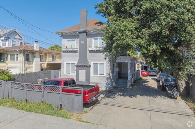
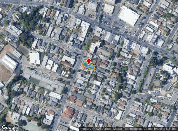
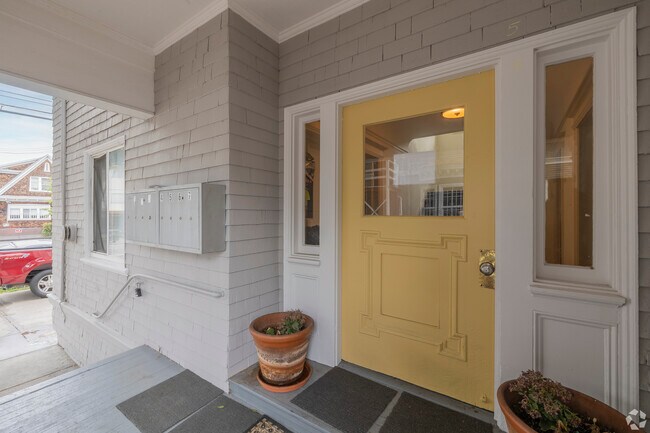
1832 Fruitvale Ave, Oakland, CA 94601
This Property Is For Sale
NEARBY LISTINGS FOR SALE OR LEASE
Property Detail
1832 Fruitvale Ave
Oakland-Hayward-Berkeley, CA
Henry & Phillips
033-2117-028-00
LOT: 00028 BLK: AR: 0033 PAGE: 2117
Multifamilydwelling
Alameda
X
California
06001C0086H
9
2024
0.15 AC
2025
Fruitvale
407200
East Bay/Oakland
3,107 SF
DEMOGRAPHICS near 1832 Fruitvale Ave
1 Mile
3 Mile
5 Mile
2024 Total Population
53,256
279,523
506,909
2029 Population
51,196
270,505
491,911
Pop Growth 2024-2029
(3.87%)
(3.23%)
(2.96%)
Average Age
38
41
41
2024 Total Households
16,077
107,603
193,616
HH Growth 2024-2029
(4.09%)
(3.26%)
(3.00%)
Median Household Inc
$56,408
$86,900
$92,829
Avg Household Size
3.00
2.40
2.40
2024 Avg HH Vehicles
2.00
2.00
2.00
Median Home Value
$680,190
$919,548
$945,359
Median Year Built
1950
1951
1954
Nearby Places
Map Layers
Map Styles
 Street
 Aerial
- Restaurants
- Banks
- Shops
- Fitness
- Groceries
PUBLIC TRANSPORTATION
TRANSIT/SUBWAY
Fruitvale Station (Berryessa/North San Jose to Daly City - Bay Area Rapid Transit (BART), Berryessa/North San Jose to Richmond - Bay Area Rapid Transit (BART), Daly City to Berryessa/North San Jose - Bay Area Rapid Transit (BART), Daly City to Dublin/Pleasanton - Bay Area Rapid Transit (BART), Dublin/Pleasanton - Millbrae - Bay Area Rapid Transit (BART), Fremont - Daly City - Bay Area Rapid Transit (BART), Fremont - Richmond - Bay Area Rapid Transit (BART), Richmond to Berryessa/North San Jose - Bay Area Rapid Transit (BART))
DRIVE
WALK
Distance
Fruitvale Station (Berryessa/North San Jose to Daly City - Bay Area Rapid Transit (BART), Berryessa/North San Jose to Richmond - Bay Area Rapid Transit (BART), Daly City to Berryessa/North San Jose - Bay Area Rapid Transit (BART), Daly City to Dublin/Pleasanton - Bay Area Rapid Transit (BART), Dublin/Pleasanton - Millbrae - Bay Area Rapid Transit (BART), Fremont - Daly City - Bay Area Rapid Transit (BART), Fremont - Richmond - Bay Area Rapid Transit (BART), Richmond to Berryessa/North San Jose - Bay Area Rapid Transit (BART))
1 min
12 min
0.6 mi
COMMUTER RAIL
Oakland (Capitol Corridor - Amtrak, Coast Starlight - Amtrak, San Joaquins - Amtrak)
DRIVE
WALK
Distance
Oakland (Capitol Corridor - Amtrak, Coast Starlight - Amtrak, San Joaquins - Amtrak)
6 min
3.7 mi
Emeryville (California Zephyr - Amtrak, Capitol Corridor - Amtrak, Coast Starlight - Amtrak, San Joaquins - Amtrak)
DRIVE
WALK
Distance
Emeryville (California Zephyr - Amtrak, Capitol Corridor - Amtrak, Coast Starlight - Amtrak, San Joaquins - Amtrak)
11 min
7.3 mi
AIRPORT
Metro Oakland International
DRIVE
WALK
Distance
Metro Oakland International
11 min
6.6 mi
San Francisco International
DRIVE
WALK
Distance
San Francisco International
39 min
26.3 mi
Freight Ports
Port of Oakland
DRIVE
WALK
Distance
Port of Oakland
7 min
4.2 mi
Nearby Properties
Address
Land Use
TOTAL SIZE
Lot Size
Zoning
Address
Land Use
TOTAL SIZE
Lot Size
Zoning
1,028,501 SF
2.74 AC
Address
Land Use
TOTAL SIZE
Lot Size
Zoning
652,524 SF
1.38 AC
Address
Land Use
TOTAL SIZE
Lot Size
Zoning
490,000 SF
1.44 AC
Address
Land Use
TOTAL SIZE
Lot Size
Zoning
Address
Land Use
TOTAL SIZE
Lot Size
Zoning
546,164 SF
6.02 AC
Address
Land Use
TOTAL SIZE
Lot Size
Zoning
621,432 SF
1.31 AC
C
Address
Land Use
TOTAL SIZE
Lot Size
Zoning
288,796 SF
0.52 AC
Address
Land Use
TOTAL SIZE
Lot Size
Zoning
371,504 SF
4.08 AC
Address
Land Use
TOTAL SIZE
Lot Size
Zoning
788,983 SF
1.63 AC
Address
Land Use
TOTAL SIZE
Lot Size
Zoning
534,208 SF
23.18 AC
Address
Land Use
TOTAL SIZE
Lot Size
Zoning
273,623 SF
1.44 AC
Address
Land Use
TOTAL SIZE
Lot Size
Zoning
297,617 SF
1.54 AC
Address
Land Use
TOTAL SIZE
Lot Size
Zoning
352,994 SF
1.38 AC
Address
Land Use
TOTAL SIZE
Lot Size
Zoning
259,247 SF
5.44 AC
R5PD
Address
Land Use
TOTAL SIZE
Lot Size
Zoning
307,808 SF
9.03 AC
Address
Land Use
TOTAL SIZE
Lot Size
Zoning
280,484 SF
0.76 AC
Address
Land Use
TOTAL SIZE
Lot Size
Zoning
699,329 SF
4.42 AC
Address
Land Use
TOTAL SIZE
Lot Size
Zoning
277,374 SF
1.38 AC
Address
Land Use
TOTAL SIZE
Lot Size
Zoning
325,955 SF
1.70 AC
Address
Land Use
TOTAL SIZE
Lot Size
Zoning
190,786 SF
3.75 AC
Address
Land Use
TOTAL SIZE
Lot Size
Zoning
525,864 SF
16.53 AC
Address
Land Use
TOTAL SIZE
Lot Size
Zoning
316,007 SF
1.58 AC
Address
Land Use
TOTAL SIZE
Lot Size
Zoning
470,570 SF
2.04 AC
Address
Land Use
TOTAL SIZE
Lot Size
Zoning
344,249 SF
1.38 AC
Address
Land Use
TOTAL SIZE
Lot Size
Zoning
180,959 SF
9.38 AC
Address
Land Use
TOTAL SIZE
Lot Size
Zoning
336,680 SF
9.93 AC
M40
Address
Land Use
TOTAL SIZE
Lot Size
Zoning
133,636 SF
5.46 AC
Address
Land Use
TOTAL SIZE
Lot Size
Zoning
248,238 SF
1.01 AC
Address
Land Use
TOTAL SIZE
Lot Size
Zoning
23,280 SF
0.24 AC
Address
Land Use
TOTAL SIZE
Lot Size
Zoning
284,255 SF
5.07 AC
The World's #1 Commercial Real Estate Marketplace
Connect with us
© 2025 CoStar Group
The information above has been obtained from sources believed reliable. While we do not doubt its accuracy we have not verified it and make no guarantee, warranty or representation about it. It is your responsibility to independently confirm its accuracy and completeness. Any projections, opinions, assumptions, or estimates used are for example only and do not represent the current or future performance of the property. The value of this transaction to you depends on tax and other factors which should be evaluated by your tax, financial, and legal advisors. You and your advisors should conduct a careful, independent investigation of the property to determine to your satisfaction the suitability of the property for your needs.