Property Record
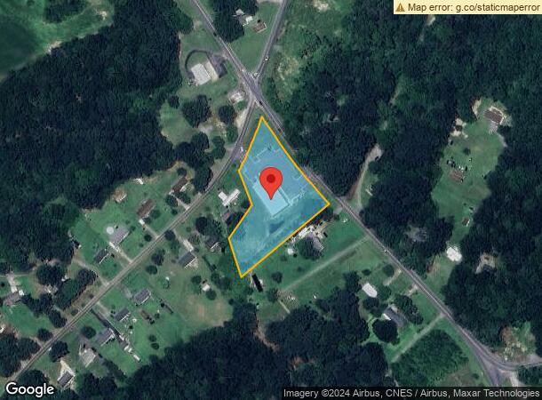
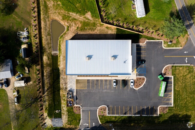
1832 Martin Rd, Bessemer City, NC 28016

NEARBY LISTINGS FOR SALE OR LEASE
-
-
View all Bessemer City listings for sale on LoopNet.com
Property Detail
1832 Martin Rd
162149
The Lands Of Sarah Pless Simmons
Departmentstoremultistory
12 073 022 04 000
X
Gaston
3710259800K
North Carolina
2025
2.17 AC
2025
Gaston County
030802
Charlotte
8,972 SF
Charlotte-Concord-Gastonia, NC-SC
DEMOGRAPHICS near 1832 Martin Rd
1 Mile
3 Mile
5 Mile
2024 Total Population
642
8,998
20,360
2029 Population
698
9,625
21,646
Pop Growth 2024-2029
+ 8.72%
+ 6.97%
+ 6.32%
Average Age
40
42
42
2024 Total Households
237
3,529
8,044
HH Growth 2024-2029
+ 8.44%
+ 7.17%
+ 6.53%
Median Household Inc
$42,656
$52,180
$51,568
Avg Household Size
2.60
2.40
2.40
2024 Avg HH Vehicles
3.00
2.00
2.00
Median Home Value
$268,518
$192,742
$174,614
Median Year Built
1987
1982
1981
Nearby Places
Map Layers
Map Styles
 Street
 Aerial
- Restaurants
- Banks
- Shops
- Fitness
- Groceries
PUBLIC TRANSPORTATION
AIRPORT
Charlotte/Douglas International
DRIVE
WALK
Distance
Charlotte/Douglas International
51 min
30.5 mi
Freight Ports
North Charleston Terminal
DRIVE
WALK
Distance
North Charleston Terminal
257 min
216.7 mi
SALE & LEASE HISTORY
LISTING DATE
SALE/LEASE

Aug 07, 2019
For Sale
Nearby Properties
Address
Land Use
TOTAL SIZE
Lot Size
Zoning
Address
Land Use
TOTAL SIZE
Lot Size
Zoning
69,747 SF
18.33 AC
R1
Address
Land Use
TOTAL SIZE
Lot Size
Zoning
3,917 SF
3.43 AC
R2
Address
Land Use
TOTAL SIZE
Lot Size
Zoning
75,190 SF
10.69 AC
PUB01
Address
Land Use
TOTAL SIZE
Lot Size
Zoning
62,238 SF
17 AC
PUB01
Address
Land Use
TOTAL SIZE
Lot Size
Zoning
1,872 SF
13.33 AC
PUB01
Address
Land Use
TOTAL SIZE
Lot Size
Zoning
6,480 SF
12.98 AC
PUB01
Address
Land Use
TOTAL SIZE
Lot Size
Zoning
41,067 SF
2.42 AC
CHUR2
Address
Land Use
TOTAL SIZE
Lot Size
Zoning
38,154 SF
26.69 AC
CHUR2
Address
Land Use
TOTAL SIZE
Lot Size
Zoning
22,808 SF
2.67 AC
HCAR4
Address
Land Use
TOTAL SIZE
Lot Size
Zoning
650 SF
4.33 AC
INDS1
Address
Land Use
TOTAL SIZE
Lot Size
Zoning
7,702 SF
1.55 AC
OFF01
Address
Land Use
TOTAL SIZE
Lot Size
Zoning
768 SF
11.52 AC
APT01
Address
Land Use
TOTAL SIZE
Lot Size
Zoning
512 SF
912.91 AC
R15
Address
Land Use
TOTAL SIZE
Lot Size
Zoning
26,004 SF
12.35 AC
CHUR2
Address
Land Use
TOTAL SIZE
Lot Size
Zoning
13,881 SF
2.48 AC
GOV06
Address
Land Use
TOTAL SIZE
Lot Size
Zoning
1,430 SF
2.57 AC
APT01
Address
Land Use
TOTAL SIZE
Lot Size
Zoning
180.22 AC
Address
Land Use
TOTAL SIZE
Lot Size
Zoning
3,811 SF
0.88 AC
REST1
Address
Land Use
TOTAL SIZE
Lot Size
Zoning
1,763 SF
1.45 AC
CHUR2
Address
Land Use
TOTAL SIZE
Lot Size
Zoning
47,180 SF
8.68 AC
SHOP4
Address
Land Use
TOTAL SIZE
Lot Size
Zoning
6,288 SF
3.05 AC
Address
Land Use
TOTAL SIZE
Lot Size
Zoning
11,145 SF
10.11 AC
INDS1
Address
Land Use
TOTAL SIZE
Lot Size
Zoning
15,746 SF
3.75 AC
GOV06
Address
Land Use
TOTAL SIZE
Lot Size
Zoning
1,400 SF
1.49 AC
APT01
Address
Land Use
TOTAL SIZE
Lot Size
Zoning
4,021 SF
1.37 AC
BANK1
Address
Land Use
TOTAL SIZE
Lot Size
Zoning
71.53 AC
R1
Address
Land Use
TOTAL SIZE
Lot Size
Zoning
4,040 SF
12.51 AC
Address
Land Use
TOTAL SIZE
Lot Size
Zoning
3,315 SF
1.41 AC
REST1
Address
Land Use
TOTAL SIZE
Lot Size
Zoning
3,729 SF
9.63 AC
APT01
Address
Land Use
TOTAL SIZE
Lot Size
Zoning
4,714 SF
20.06 AC
R1
The World's #1 Commercial Real Estate Marketplace
Connect with us
© 2025 CoStar Group
The information above has been obtained from sources believed reliable. While we do not doubt its accuracy we have not verified it and make no guarantee, warranty or representation about it. It is your responsibility to independently confirm its accuracy and completeness. Any projections, opinions, assumptions, or estimates used are for example only and do not represent the current or future performance of the property. The value of this transaction to you depends on tax and other factors which should be evaluated by your tax, financial, and legal advisors. You and your advisors should conduct a careful, independent investigation of the property to determine to your satisfaction the suitability of the property for your needs.