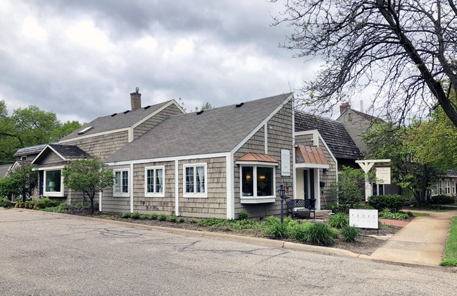
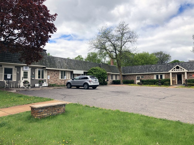
Property Record
18320 Minnetonka Blvd, Wayzata, MN 55391

Current Lease Availabilities
NEARBY LISTINGS FOR SALE OR LEASE
Property Detail
18320 Minnetonka Blvd
Minneapolis-St. Paul-Bloomington, MN-WI
Unplatted 18 117 22
18-117-22-31-0108
UNPLATTED 18 117 22 ALL THAT PART OF NE 1/4 OF SW 1/4 DESC AS FOL BEG AT A PT ON E LINE OF NE 1/4 OF SW 1/4 DIST 663 FT S FROM NE COR THOF TH W AT R/A DIST 231 FT T E 330 X 198
Commercialnec
Hennepin
X
Minnesota
27019C0110D
3
2024
1.50 AC
2024
I-394 Corridor
027300
Minneapolis/St Paul
DEMOGRAPHICS near 18320 Minnetonka Blvd
1 Mile
3 Mile
5 Mile
2024 Total Population
4,623
30,811
106,801
2029 Population
4,581
30,333
105,868
Pop Growth 2024-2029
(0.91%)
(1.55%)
(0.87%)
Average Age
43
44
43
2024 Total Households
1,733
12,243
43,327
HH Growth 2024-2029
(1.04%)
(1.63%)
(0.99%)
Median Household Inc
$150,514
$136,132
$119,900
Avg Household Size
2.60
2.50
2.40
2024 Avg HH Vehicles
2.00
2.00
2.00
Median Home Value
$541,887
$509,006
$462,596
Median Year Built
1964
1974
1979
Nearby Places
Map Layers
Map Styles
 Street
 Aerial
- Restaurants
- Banks
- Shops
- Fitness
- Groceries
PUBLIC TRANSPORTATION
AIRPORT
Minneapolis-St Paul International/Wold-Chamberlain
DRIVE
WALK
Distance
Minneapolis-St Paul International/Wold-Chamberlain
31 min
20.5 mi
Freight Ports
Port Milwaukee
DRIVE
WALK
Distance
Port Milwaukee
394 min
352.8 mi
Nearby Properties
Address
Land Use
TOTAL SIZE
Lot Size
Zoning
Address
Land Use
TOTAL SIZE
Lot Size
Zoning
171,900 SF
39.17 AC
B1
Address
Land Use
TOTAL SIZE
Lot Size
Zoning
2.18 AC
Address
Land Use
TOTAL SIZE
Lot Size
Zoning
2.12 AC
Address
Land Use
TOTAL SIZE
Lot Size
Zoning
0.07 AC
Address
Land Use
TOTAL SIZE
Lot Size
Zoning
81,834 SF
16.20 AC
PID
Address
Land Use
TOTAL SIZE
Lot Size
Zoning
7.51 AC
Address
Land Use
TOTAL SIZE
Lot Size
Zoning
3.08 AC
Address
Land Use
TOTAL SIZE
Lot Size
Zoning
0.48 AC
Address
Land Use
TOTAL SIZE
Lot Size
Zoning
0.88 AC
Address
Land Use
TOTAL SIZE
Lot Size
Zoning
0.99 AC
Address
Land Use
TOTAL SIZE
Lot Size
Zoning
0.44 AC
Address
Land Use
TOTAL SIZE
Lot Size
Zoning
1.37 AC
Address
Land Use
TOTAL SIZE
Lot Size
Zoning
7,209 SF
2.53 AC
B1
Address
Land Use
TOTAL SIZE
Lot Size
Zoning
1.87 AC
Address
Land Use
TOTAL SIZE
Lot Size
Zoning
177,644 SF
10.49 AC
I1
Address
Land Use
TOTAL SIZE
Lot Size
Zoning
0.57 AC
Address
Land Use
TOTAL SIZE
Lot Size
Zoning
29,091 SF
34.94 AC
PUD
Address
Land Use
TOTAL SIZE
Lot Size
Zoning
7.82 AC
R4
Address
Land Use
TOTAL SIZE
Lot Size
Zoning
9.29 AC
R4
Address
Land Use
TOTAL SIZE
Lot Size
Zoning
0.41 AC
Address
Land Use
TOTAL SIZE
Lot Size
Zoning
88,948 SF
10.14 AC
B2
Address
Land Use
TOTAL SIZE
Lot Size
Zoning
14.04 AC
R4
Address
Land Use
TOTAL SIZE
Lot Size
Zoning
38,825 SF
5.38 AC
B3
Address
Land Use
TOTAL SIZE
Lot Size
Zoning
7.04 AC
Address
Land Use
TOTAL SIZE
Lot Size
Zoning
0.34 AC
Address
Land Use
TOTAL SIZE
Lot Size
Zoning
5.06 AC
Address
Land Use
TOTAL SIZE
Lot Size
Zoning
9.82 AC
Address
Land Use
TOTAL SIZE
Lot Size
Zoning
0.56 AC
Address
Land Use
TOTAL SIZE
Lot Size
Zoning
2.75 AC
Address
Land Use
TOTAL SIZE
Lot Size
Zoning
4.81 AC
The World's #1 Commercial Real Estate Marketplace
Connect with us
© 2025 CoStar Group
The information above has been obtained from sources believed reliable. While we do not doubt its accuracy we have not verified it and make no guarantee, warranty or representation about it. It is your responsibility to independently confirm its accuracy and completeness. Any projections, opinions, assumptions, or estimates used are for example only and do not represent the current or future performance of the property. The value of this transaction to you depends on tax and other factors which should be evaluated by your tax, financial, and legal advisors. You and your advisors should conduct a careful, independent investigation of the property to determine to your satisfaction the suitability of the property for your needs.