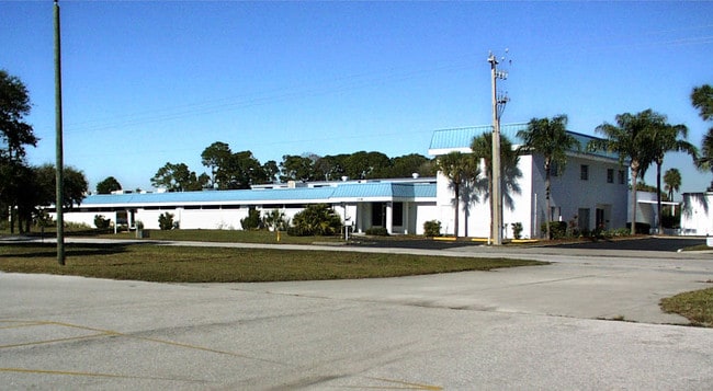
Property Record
1833 57Th St, Sarasota, FL 34243

NEARBY LISTINGS FOR SALE OR LEASE
Property Detail
1833 57Th St
0024-09-0001
Desoto Acres
Lightindustrial
BEG AT INTRS OF C/L OF DESOTO RD 80 FT ROW & W LINE US HWY 301 200 FT ROW TH N-0-10-E ALONG W LINE SAID HWY 683.05 FT TH N-89-14-W & PARL TO DESOTO RD 676.74 FT FOR POB TH CONT N-89- 14-W 400
AE
Sarasota
12115C0043G
Florida
2024
6.80 AC
2025
Sarasota
001101
Tampa/St Petersburg
42,900 SF
North Port-Bradenton-Sarasota, FL
DEMOGRAPHICS near 1833 57Th St
1 mile
3 mile
5 mile
2024 Total Population
4,859
55,480
170,155
2029 Population
5,649
63,701
196,714
Pop Growth 2024-2029
+ 16.26%
+ 14.82%
+ 15.61%
Average Age
47
44
47
2024 Total Households
2,327
24,057
75,658
HH Growth 2024-2029
+ 15.94%
+ 14.58%
+ 15.31%
Median Household Inc
$56,818
$60,951
$61,288
Avg Household Size
1.90
2.10
2.10
2024 Avg HH Vehicles
1.00
2.00
2.00
Median Home Value
$217,324
$278,635
$290,987
Median Year Built
1986
1984
1983
Nearby Places
Map Layers
Map Styles
 Street
 Aerial
Transit
 Traffic
 Biking
Places
Listings with unknown addresses are not visible on the map
- Restaurants
- Banks
- Shops
- Fitness
- Groceries
PUBLIC TRANSPORTATION
AIRPORT
Sarasota/Bradenton International
Drive
Walk
Distance
Sarasota/Bradenton International
7 min
2.9 mi
Freight Ports
Port Manatee
Drive
Walk
Distance
Port Manatee
34 min
20.7 mi
Nearby Properties
Address
Land Use
TOTAL SIZE
Lot Size
Zoning
Address
Land Use
TOTAL SIZE
Lot Size
Zoning
1,023,770 SF
76.55 AC
Address
Land Use
TOTAL SIZE
Lot Size
Zoning
390,439 SF
143.53 AC
AA
Address
Land Use
TOTAL SIZE
Lot Size
Zoning
252,425 SF
44.30 AC
G
Address
Land Use
TOTAL SIZE
Lot Size
Zoning
458,955 SF
3.99 AC
DTE
Address
Land Use
TOTAL SIZE
Lot Size
Zoning
298,916 SF
36.99 AC
G
Address
Land Use
TOTAL SIZE
Lot Size
Zoning
425,298 SF
25.59 AC
PD-R
Address
Land Use
TOTAL SIZE
Lot Size
Zoning
394,304 SF
2.85 AC
DTE
Address
Land Use
TOTAL SIZE
Lot Size
Zoning
331,241 SF
44.24 AC
Address
Land Use
TOTAL SIZE
Lot Size
Zoning
150,740 SF
38.70 AC
MCI
Address
Land Use
TOTAL SIZE
Lot Size
Zoning
309,573 SF
7.06 AC
ORD
Address
Land Use
TOTAL SIZE
Lot Size
Zoning
272,602 SF
28.35 AC
PD-R
Address
Land Use
TOTAL SIZE
Lot Size
Zoning
328,066 SF
7.88 AC
PD-MU
Address
Land Use
TOTAL SIZE
Lot Size
Zoning
296,343 SF
26.53 AC
PD-R
Address
Land Use
TOTAL SIZE
Lot Size
Zoning
152,405 SF
20.44 AC
MCI
Address
Land Use
TOTAL SIZE
Lot Size
Zoning
251,472 SF
11 AC
RSF2
Address
Land Use
TOTAL SIZE
Lot Size
Zoning
331,816 SF
574.64 AC
Address
Land Use
TOTAL SIZE
Lot Size
Zoning
296,612 SF
576.25 AC
PD-MU
Address
Land Use
TOTAL SIZE
Lot Size
Zoning
264,317 SF
9.55 AC
PD-MU
Address
Land Use
TOTAL SIZE
Lot Size
Zoning
112,310 SF
36.83 AC
G
Address
Land Use
TOTAL SIZE
Lot Size
Zoning
8,796 SF
69.53 AC
RMH
Address
Land Use
TOTAL SIZE
Lot Size
Zoning
109,325 SF
15.55 AC
G
Address
Land Use
TOTAL SIZE
Lot Size
Zoning
176,160 SF
9.62 AC
ORD
Address
Land Use
TOTAL SIZE
Lot Size
Zoning
265,365 SF
6.68 AC
PD-MU
Address
Land Use
TOTAL SIZE
Lot Size
Zoning
195,271 SF
42.40 AC
GU
Address
Land Use
TOTAL SIZE
Lot Size
Zoning
211,318 SF
15.99 AC
DTE
Address
Land Use
TOTAL SIZE
Lot Size
Zoning
64,288 SF
12.90 AC
RSF1
Address
Land Use
TOTAL SIZE
Lot Size
Zoning
126,111 SF
38.38 AC
RSF2
Address
Land Use
TOTAL SIZE
Lot Size
Zoning
238,774 SF
15.56 AC
A-1 SUBURB
Address
Land Use
TOTAL SIZE
Lot Size
Zoning
75,460 SF
5.92 AC
G
Address
Land Use
TOTAL SIZE
Lot Size
Zoning
359,950 SF
34.91 AC
LM LIGHT M
The World's #1 Commercial Real Estate Marketplace
Connect with us
© 2026 CoStar Group
The information above has been obtained from sources believed reliable. While we do not doubt its accuracy we have not verified it and make no guarantee, warranty or representation about it. It is your responsibility to independently confirm its accuracy and completeness. Any projections, opinions, assumptions, or estimates used are for example only and do not represent the current or future performance of the property. The value of this transaction to you depends on tax and other factors which should be evaluated by your tax, financial, and legal advisors. You and your advisors should conduct a careful, independent investigation of the property to determine to your satisfaction the suitability of the property for your needs.