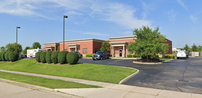
Property Record
1835 Successful Dr, Fairborn, OH 45324


Current Lease Availabilities
NEARBY LISTINGS FOR SALE OR LEASE
Property Detail
1835 Successful Dr
Dayton, OH
Valle Greene North Section Thirteen
A02-0002-0047-0-0015-00
VALLE GREENE NORTH SEC 13 LOT 8586 1.4911AC SUCCESSFUL DR
Commercialnec
Greene
X
Ohio
39057C0040E
8586
2024
1.49 AC
2024
East Dayton
200901
Cincinnati/Dayton
11,918 SF
DEMOGRAPHICS near 1835 Successful Dr
1 Mile
3 Mile
5 Mile
2024 Total Population
4,595
37,756
72,889
2029 Population
4,787
38,805
75,108
Pop Growth 2024-2029
+ 4.18%
+ 2.78%
+ 3.04%
Average Age
41
39
39
2024 Total Households
2,152
16,640
30,755
HH Growth 2024-2029
+ 4.23%
+ 2.75%
+ 3.17%
Median Household Inc
$90,850
$67,284
$74,436
Avg Household Size
2.10
2.20
2.30
2024 Avg HH Vehicles
2.00
2.00
2.00
Median Home Value
$219,026
$171,796
$208,253
Median Year Built
1995
1973
1979
Nearby Places
Map Layers
Map Styles
 Street
 Aerial
- Restaurants
- Banks
- Shops
- Fitness
- Groceries
PUBLIC TRANSPORTATION
AIRPORT
James M Cox Dayton International
DRIVE
WALK
Distance
James M Cox Dayton International
31 min
22.4 mi
Freight Ports
Port of Toledo
DRIVE
WALK
Distance
Port of Toledo
190 min
162.6 mi
Nearby Properties
Address
Land Use
TOTAL SIZE
Lot Size
Zoning
Address
Land Use
TOTAL SIZE
Lot Size
Zoning
7,087 SF
31.93 AC
MX-PUD 93-
Address
Land Use
TOTAL SIZE
Lot Size
Zoning
101,768 SF
22.02 AC
B1
Address
Land Use
TOTAL SIZE
Lot Size
Zoning
27,740 SF
11.16 AC
MXPUD93
Address
Land Use
TOTAL SIZE
Lot Size
Zoning
3,038 SF
13.49 AC
RPUD936
Address
Land Use
TOTAL SIZE
Lot Size
Zoning
57,816 SF
9.15 AC
PD1
Address
Land Use
TOTAL SIZE
Lot Size
Zoning
594,070 SF
43.95 AC
AG
Address
Land Use
TOTAL SIZE
Lot Size
Zoning
45,204 SF
14.92 AC
PD1
Address
Land Use
TOTAL SIZE
Lot Size
Zoning
46,802 SF
25.30 AC
R3
Address
Land Use
TOTAL SIZE
Lot Size
Zoning
1,630 SF
8.41 AC
MXPUD93
Address
Land Use
TOTAL SIZE
Lot Size
Zoning
163,780 SF
36.93 AC
PARK
Address
Land Use
TOTAL SIZE
Lot Size
Zoning
278,290 SF
18.87 AC
AG
Address
Land Use
TOTAL SIZE
Lot Size
Zoning
7,040 SF
55.41 AC
R2
Address
Land Use
TOTAL SIZE
Lot Size
Zoning
121,790 SF
14.50 AC
MXPUD93
Address
Land Use
TOTAL SIZE
Lot Size
Zoning
7,772 SF
8.52 AC
R3
Address
Land Use
TOTAL SIZE
Lot Size
Zoning
14,496 SF
0.64 AC
2
Address
Land Use
TOTAL SIZE
Lot Size
Zoning
46,656 SF
10.35 AC
PD1
Address
Land Use
TOTAL SIZE
Lot Size
Zoning
100,197 SF
9.38 AC
MX-PUD 93-
Address
Land Use
TOTAL SIZE
Lot Size
Zoning
84,032 SF
10.08 AC
RPUD936
Address
Land Use
TOTAL SIZE
Lot Size
Zoning
261,152 SF
15.63 AC
B3
Address
Land Use
TOTAL SIZE
Lot Size
Zoning
51,279 SF
2.58 AC
PD1
Address
Land Use
TOTAL SIZE
Lot Size
Zoning
24,512 SF
6.73 AC
PD1
Address
Land Use
TOTAL SIZE
Lot Size
Zoning
24,522 SF
8.46 AC
R3
Address
Land Use
TOTAL SIZE
Lot Size
Zoning
46,005 SF
9.33 AC
PD4
Address
Land Use
TOTAL SIZE
Lot Size
Zoning
11,760 SF
8.02 AC
R2
Address
Land Use
TOTAL SIZE
Lot Size
Zoning
18,230 SF
121.78 AC
RPUD936
Address
Land Use
TOTAL SIZE
Lot Size
Zoning
17,600 SF
16.43 AC
Address
Land Use
TOTAL SIZE
Lot Size
Zoning
24,512 SF
5.75 AC
PD1
Address
Land Use
TOTAL SIZE
Lot Size
Zoning
1,526 SF
627.09 AC
Address
Land Use
TOTAL SIZE
Lot Size
Zoning
3,456 SF
5.66 AC
PD1
Address
Land Use
TOTAL SIZE
Lot Size
Zoning
31,338 SF
0.25 AC
B2
The World's #1 Commercial Real Estate Marketplace
Connect with us
© 2026 CoStar Group
The information above has been obtained from sources believed reliable. While we do not doubt its accuracy we have not verified it and make no guarantee, warranty or representation about it. It is your responsibility to independently confirm its accuracy and completeness. Any projections, opinions, assumptions, or estimates used are for example only and do not represent the current or future performance of the property. The value of this transaction to you depends on tax and other factors which should be evaluated by your tax, financial, and legal advisors. You and your advisors should conduct a careful, independent investigation of the property to determine to your satisfaction the suitability of the property for your needs.