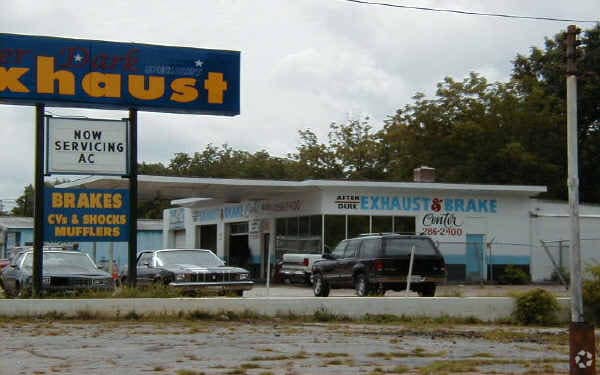
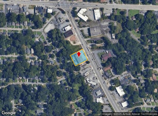
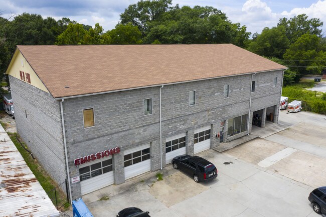
Property Record
1835 Candler Rd, Decatur, GA 30032

NEARBY LISTINGS FOR SALE OR LEASE
Property Detail
1835 Candler Rd
Atlanta-Sandy Springs-Roswell, GA
Magnoila Garden
15-170-12-009
150 X 174 X 150 X 172 .......... .60 AC
Autorepair
DeKalb
X
Georgia
13089C0131J
12-14
2025
0.60 AC
2025
Decatur/East Atl
023601
Atlanta
20,000 SF
DEMOGRAPHICS near 1835 Candler Rd
1 Mile
3 Mile
5 Mile
2024 Total Population
10,522
105,016
280,874
2029 Population
10,602
105,472
283,542
Pop Growth 2024-2029
+ 0.76%
+ 0.43%
+ 0.95%
Average Age
41
40
39
2024 Total Households
4,456
43,895
118,759
HH Growth 2024-2029
+ 0.74%
+ 0.49%
+ 1.16%
Median Household Inc
$62,696
$68,231
$76,155
Avg Household Size
2.30
2.30
2.20
2024 Avg HH Vehicles
2.00
2.00
2.00
Median Home Value
$325,089
$356,419
$361,695
Median Year Built
1958
1967
1975
Nearby Places
Map Layers
Map Styles
 Street
 Aerial
- Restaurants
- Banks
- Shops
- Fitness
- Groceries
PUBLIC TRANSPORTATION
AIRPORT
Hartsfield - Jackson Atlanta International
DRIVE
WALK
Distance
Hartsfield - Jackson Atlanta International
24 min
14.4 mi
SALE & LEASE HISTORY
LISTING DATE
SALE/LEASE

Jun 05, 2020
For Sale
Feb 19, 2020
For Sale
Aug 14, 2019
For Sale
Nearby Properties
Address
Land Use
TOTAL SIZE
Lot Size
Zoning
Address
Land Use
TOTAL SIZE
Lot Size
Zoning
123,732 SF
0.51 AC
RM75
Address
Land Use
TOTAL SIZE
Lot Size
Zoning
327,098 SF
4.92 AC
X
Address
Land Use
TOTAL SIZE
Lot Size
Zoning
99,770 SF
2.14 AC
Address
Land Use
TOTAL SIZE
Lot Size
Zoning
290,130 SF
6.13 AC
R100
Address
Land Use
TOTAL SIZE
Lot Size
Zoning
67,882 SF
4.77 AC
X
Address
Land Use
TOTAL SIZE
Lot Size
Zoning
350,556 SF
46.09 AC
X
Address
Land Use
TOTAL SIZE
Lot Size
Zoning
244,293 SF
2.09 AC
C-2
Address
Land Use
TOTAL SIZE
Lot Size
Zoning
298,763 SF
3.27 AC
M
Address
Land Use
TOTAL SIZE
Lot Size
Zoning
104,501 SF
2.56 AC
X
Address
Land Use
TOTAL SIZE
Lot Size
Zoning
81,129 SF
4.29 AC
C1
Address
Land Use
TOTAL SIZE
Lot Size
Zoning
76,654 SF
3.14 AC
C-1
Address
Land Use
TOTAL SIZE
Lot Size
Zoning
93,584 SF
0.66 AC
X
Address
Land Use
TOTAL SIZE
Lot Size
Zoning
286,700 SF
2.48 AC
G-C
Address
Land Use
TOTAL SIZE
Lot Size
Zoning
105,624 SF
11.62 AC
MR-2
Address
Land Use
TOTAL SIZE
Lot Size
Zoning
104,218 SF
1.10 AC
C2
Address
Land Use
TOTAL SIZE
Lot Size
Zoning
234,053 SF
16.80 AC
RM75
Address
Land Use
TOTAL SIZE
Lot Size
Zoning
91,622 SF
18.99 AC
X
Address
Land Use
TOTAL SIZE
Lot Size
Zoning
522,850 SF
41.34 AC
RM75
Address
Land Use
TOTAL SIZE
Lot Size
Zoning
278,121 SF
20 AC
RM85
Address
Land Use
TOTAL SIZE
Lot Size
Zoning
64,296 SF
0.37 AC
X
Address
Land Use
TOTAL SIZE
Lot Size
Zoning
191,425 SF
2.45 AC
C2: GEN CO
Address
Land Use
TOTAL SIZE
Lot Size
Zoning
72,870 SF
12.34 AC
C2
Address
Land Use
TOTAL SIZE
Lot Size
Zoning
137,771 SF
1.53 AC
RM75
Address
Land Use
TOTAL SIZE
Lot Size
Zoning
56,862 SF
1.41 AC
C2: GEN CO
Address
Land Use
TOTAL SIZE
Lot Size
Zoning
245,053 SF
22.77 AC
RM85
Address
Land Use
TOTAL SIZE
Lot Size
Zoning
13,114 SF
17.54 AC
RM100
Address
Land Use
TOTAL SIZE
Lot Size
Zoning
295,632 SF
19.26 AC
RM75
Address
Land Use
TOTAL SIZE
Lot Size
Zoning
256,445 SF
11.71 AC
RM85
Address
Land Use
TOTAL SIZE
Lot Size
Zoning
40,809 SF
2.37 AC
C-1
Address
Land Use
TOTAL SIZE
Lot Size
Zoning
151,107 SF
X
The World's #1 Commercial Real Estate Marketplace
Connect with us
© 2025 CoStar Group
The information above has been obtained from sources believed reliable. While we do not doubt its accuracy we have not verified it and make no guarantee, warranty or representation about it. It is your responsibility to independently confirm its accuracy and completeness. Any projections, opinions, assumptions, or estimates used are for example only and do not represent the current or future performance of the property. The value of this transaction to you depends on tax and other factors which should be evaluated by your tax, financial, and legal advisors. You and your advisors should conduct a careful, independent investigation of the property to determine to your satisfaction the suitability of the property for your needs.