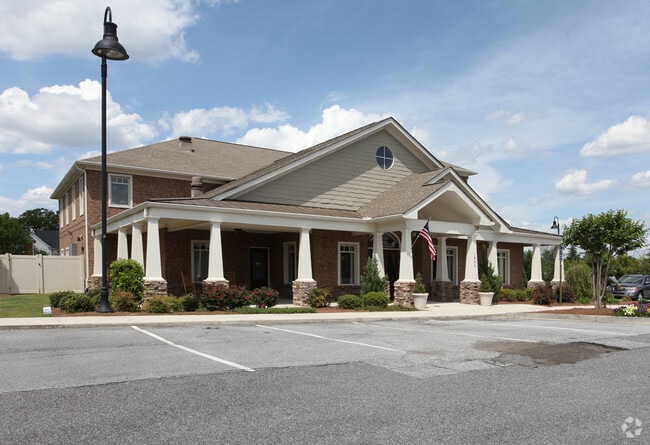
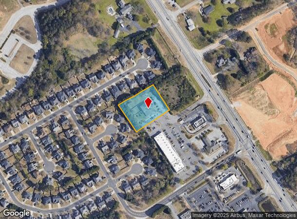
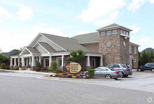
Property Record
1835 Grayson Hwy, Grayson, GA 30017
Property Detail
1835 Grayson Hwy
Atlanta-Sandy Springs-Roswell, GA
Grayson Exchange
5-136-106
LOT D GEORGIA HIGHWAY 20
Animalhospitalvet
Gwinnett
X
Georgia
13135C0118F
d
2025
1.24 AC
2025
Lawrenceville/Dacula
050745
Atlanta
8,728 SF
NEARBY LISTINGS FOR SALE OR LEASE
DEMOGRAPHICS near 1835 Grayson Hwy
1 mile
3 mile
5 mile
2024 Total Population
8,228
62,470
171,915
2029 Population
8,760
65,537
180,014
Pop Growth 2024-2029
+ 6.47%
+ 4.91%
+ 4.71%
Average Age
41
38
38
2024 Total Households
2,759
19,823
53,918
HH Growth 2024-2029
+ 6.60%
+ 4.99%
+ 4.80%
Median Household Inc
$121,827
$92,388
$85,801
Avg Household Size
2.90
3.10
3.10
2024 Avg HH Vehicles
2.00
2.00
2.00
Median Home Value
$368,366
$326,799
$312,810
Median Year Built
2005
2001
1998
Nearby Places
Map Layers
Map Styles
 Street
 Aerial
Transit
 Traffic
 Biking
Places
Listings with unknown addresses are not visible on the map
- Restaurants
- Banks
- Shops
- Fitness
- Groceries
Nearby Properties
Address
Land Use
TOTAL SIZE
Lot Size
Zoning
Address
Land Use
TOTAL SIZE
Lot Size
Zoning
484,262 SF
34.27 AC
RM
Address
Land Use
TOTAL SIZE
Lot Size
Zoning
352,924 SF
86.43 AC
R100
Address
Land Use
TOTAL SIZE
Lot Size
Zoning
360,279 SF
13.16 AC
RM24
Address
Land Use
TOTAL SIZE
Lot Size
Zoning
349,060 SF
59.85 AC
R100
Address
Land Use
TOTAL SIZE
Lot Size
Zoning
333,734 SF
24 AC
BG
Address
Land Use
TOTAL SIZE
Lot Size
Zoning
271,668 SF
20.13 AC
RM13
Address
Land Use
TOTAL SIZE
Lot Size
Zoning
221,082 SF
12.90 AC
RM24
Address
Land Use
TOTAL SIZE
Lot Size
Zoning
194,295 SF
36.59 AC
R100
Address
Land Use
TOTAL SIZE
Lot Size
Zoning
274,964 SF
27.82 AC
BG
Address
Land Use
TOTAL SIZE
Lot Size
Zoning
214,399 SF
29.91 AC
C2
Address
Land Use
TOTAL SIZE
Lot Size
Zoning
222,622 SF
49.17 AC
R100
Address
Land Use
TOTAL SIZE
Lot Size
Zoning
145,681 SF
49.84 AC
RA200
Address
Land Use
TOTAL SIZE
Lot Size
Zoning
309,156 SF
17.39 AC
OI
Address
Land Use
TOTAL SIZE
Lot Size
Zoning
59,949 SF
71.12 AC
C1
Address
Land Use
TOTAL SIZE
Lot Size
Zoning
4,408 SF
148.92 AC
R100
Address
Land Use
TOTAL SIZE
Lot Size
Zoning
186,309 SF
15.53 AC
RM
Address
Land Use
TOTAL SIZE
Lot Size
Zoning
160,939 SF
25.46 AC
R75
Address
Land Use
TOTAL SIZE
Lot Size
Zoning
118,804 SF
17.66 AC
C2
Address
Land Use
TOTAL SIZE
Lot Size
Zoning
105,948 SF
1.24 AC
BG
Address
Land Use
TOTAL SIZE
Lot Size
Zoning
101,193 SF
5.34 AC
C2
Address
Land Use
TOTAL SIZE
Lot Size
Zoning
107,829 SF
7.82 AC
RM
Address
Land Use
TOTAL SIZE
Lot Size
Zoning
51,704 SF
17.25 AC
OI
Address
Land Use
TOTAL SIZE
Lot Size
Zoning
131,121 SF
12.99 AC
BG
Address
Land Use
TOTAL SIZE
Lot Size
Zoning
218,973 SF
21.04 AC
BG
Address
Land Use
TOTAL SIZE
Lot Size
Zoning
111,960 SF
19.68 AC
C2
Address
Land Use
TOTAL SIZE
Lot Size
Zoning
87,365 SF
11.32 AC
BG
Address
Land Use
TOTAL SIZE
Lot Size
Zoning
108,123 SF
13.96 AC
R100
Address
Land Use
TOTAL SIZE
Lot Size
Zoning
93,046 SF
82 AC
R100
Address
Land Use
TOTAL SIZE
Lot Size
Zoning
66,544 SF
6.70 AC
BG
Address
Land Use
TOTAL SIZE
Lot Size
Zoning
103,660 SF
9.58 AC
BG
The World's #1 Commercial Real Estate Marketplace
Connect with us
© 2026 CoStar Group
The information above has been obtained from sources believed reliable. While we do not doubt its accuracy we have not verified it and make no guarantee, warranty or representation about it. It is your responsibility to independently confirm its accuracy and completeness. Any projections, opinions, assumptions, or estimates used are for example only and do not represent the current or future performance of the property. The value of this transaction to you depends on tax and other factors which should be evaluated by your tax, financial, and legal advisors. You and your advisors should conduct a careful, independent investigation of the property to determine to your satisfaction the suitability of the property for your needs.