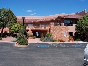
Property Record
1835 W State Route 89A, Sedona, AZ 86336


NEARBY LISTINGS FOR SALE OR LEASE
Property Detail
1835 W State Route 89A
408-26-029W
A PCL OF LAND LYING IN E2SW4SW4 OF SEC 12 17 5E BEING APPROX 970 FT E OF THE SW COR OF SAID SEC CONT 3.15 AC MORE OR LESS LESS 2.0 0 AC 1338 163 BAL 1.15 AC
Stripcommercialcenter
Yavapai
X
Arizona
04025C1435H
1.15 AC
2024
Prescott & Sedona
2026
Other Market Areas
001801
Prescott, AZ
14,283 SF
DEMOGRAPHICS near 1835 W State Route 89A
1 Mile
3 Mile
5 Mile
2024 Total Population
5,130
11,462
13,006
2029 Population
5,739
12,609
14,395
Pop Growth 2024-2029
+ 11.87%
+ 10.01%
+ 10.68%
Average Age
55
56
56
2024 Total Households
2,658
5,821
6,607
HH Growth 2024-2029
+ 12.23%
+ 10.02%
+ 10.75%
Median Household Inc
$58,584
$60,055
$59,026
Avg Household Size
1.90
1.90
1.90
2024 Avg HH Vehicles
2.00
2.00
2.00
Median Home Value
$574,542
$663,527
$656,536
Median Year Built
1988
1987
1987
Nearby Places
Map Layers
Map Styles
 Street
 Aerial
- Restaurants
- Banks
- Shops
- Fitness
- Groceries
PUBLIC TRANSPORTATION
AIRPORT
Flagstaff Pulliam
DRIVE
WALK
Distance
Flagstaff Pulliam
53 min
27.5 mi
Freight Ports
Port of San Diego
DRIVE
WALK
Distance
Port of San Diego
508 min
461.7 mi
SALE & LEASE HISTORY
LISTING DATE
SALE/LEASE

Nov 23, 2016
For Lease
Mar 17, 2020
For Lease
Jan 09, 2018
For Lease
Nearby Properties
Address
Land Use
TOTAL SIZE
Lot Size
Zoning
Address
Land Use
TOTAL SIZE
Lot Size
Zoning
1 SF
23.98 AC
Address
Land Use
TOTAL SIZE
Lot Size
Zoning
71,345 SF
4.70 AC
Address
Land Use
TOTAL SIZE
Lot Size
Zoning
79,245 SF
4.33 AC
Address
Land Use
TOTAL SIZE
Lot Size
Zoning
69,838 SF
3.83 AC
Address
Land Use
TOTAL SIZE
Lot Size
Zoning
97,885 SF
10.15 AC
Address
Land Use
TOTAL SIZE
Lot Size
Zoning
42,008 SF
4.99 AC
Address
Land Use
TOTAL SIZE
Lot Size
Zoning
44,792 SF
3.69 AC
Address
Land Use
TOTAL SIZE
Lot Size
Zoning
26,119 SF
5.36 AC
Address
Land Use
TOTAL SIZE
Lot Size
Zoning
31,064 SF
4.24 AC
Address
Land Use
TOTAL SIZE
Lot Size
Zoning
33,373 SF
3.33 AC
Address
Land Use
TOTAL SIZE
Lot Size
Zoning
22,132 SF
1.23 AC
Address
Land Use
TOTAL SIZE
Lot Size
Zoning
27,684 SF
1.61 AC
Address
Land Use
TOTAL SIZE
Lot Size
Zoning
10,000 SF
18.75 AC
Address
Land Use
TOTAL SIZE
Lot Size
Zoning
109,033 SF
11.36 AC
Address
Land Use
TOTAL SIZE
Lot Size
Zoning
1 SF
24.02 AC
Address
Land Use
TOTAL SIZE
Lot Size
Zoning
20,404 SF
1.12 AC
Address
Land Use
TOTAL SIZE
Lot Size
Zoning
8,000 SF
20.08 AC
Address
Land Use
TOTAL SIZE
Lot Size
Zoning
18.01 AC
Address
Land Use
TOTAL SIZE
Lot Size
Zoning
29,489 SF
2.33 AC
Address
Land Use
TOTAL SIZE
Lot Size
Zoning
17.98 AC
Address
Land Use
TOTAL SIZE
Lot Size
Zoning
27,176 SF
1.77 AC
Address
Land Use
TOTAL SIZE
Lot Size
Zoning
10,489 SF
0.73 AC
Address
Land Use
TOTAL SIZE
Lot Size
Zoning
12,780 SF
5.28 AC
Address
Land Use
TOTAL SIZE
Lot Size
Zoning
29,691 SF
2.66 AC
Address
Land Use
TOTAL SIZE
Lot Size
Zoning
57,544 SF
2.70 AC
Address
Land Use
TOTAL SIZE
Lot Size
Zoning
20,012 SF
1.57 AC
Address
Land Use
TOTAL SIZE
Lot Size
Zoning
24,650 SF
2.14 AC
Address
Land Use
TOTAL SIZE
Lot Size
Zoning
13,324 SF
1.61 AC
Address
Land Use
TOTAL SIZE
Lot Size
Zoning
17,069 SF
2.31 AC
Address
Land Use
TOTAL SIZE
Lot Size
Zoning
13,155 SF
1.66 AC
The World's #1 Commercial Real Estate Marketplace
Connect with us
© 2025 CoStar Group
The information above has been obtained from sources believed reliable. While we do not doubt its accuracy we have not verified it and make no guarantee, warranty or representation about it. It is your responsibility to independently confirm its accuracy and completeness. Any projections, opinions, assumptions, or estimates used are for example only and do not represent the current or future performance of the property. The value of this transaction to you depends on tax and other factors which should be evaluated by your tax, financial, and legal advisors. You and your advisors should conduct a careful, independent investigation of the property to determine to your satisfaction the suitability of the property for your needs.