Property Record
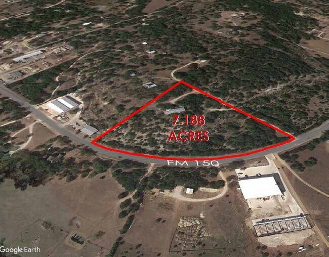
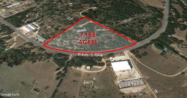
18351 Fm 150 W, Driftwood, TX 78619

Property Detail
18351 Fm 150 W
R19857
Fannie A D Darden Survey
Vacantlandnec
ABS 664 FANNIE A D DARDEN SURVEY 5.178 AC GEO#90401734
X
Hays
48209C0120F
Texas
2024
5.18 AC
2025
Hays County
010806
Austin
3,746 SF
Austin-Round Rock-San Marcos, TX
NEARBY LISTINGS FOR SALE OR LEASE
DEMOGRAPHICS near 18351 Fm 150 W
1 mile
3 mile
5 mile
2024 Total Population
473
6,621
28,850
2029 Population
622
8,776
38,249
Pop Growth 2024-2029
+ 31.50%
+ 32.55%
+ 32.58%
Average Age
41
39
39
2024 Total Households
169
2,203
9,881
HH Growth 2024-2029
+ 32.54%
+ 33.45%
+ 33.61%
Median Household Inc
$130,952
$150,819
$146,393
Avg Household Size
2.80
3.00
2.90
2024 Avg HH Vehicles
3.00
2.00
2.00
Median Home Value
$764,563
$683,141
$637,706
Median Year Built
2010
2010
2010
Nearby Places
Map Layers
Map Styles
 Street
 Aerial
Transit
 Traffic
 Biking
Places
Listings with unknown addresses are not visible on the map
- Restaurants
- Banks
- Shops
- Fitness
- Groceries
PUBLIC TRANSPORTATION
AIRPORT
Austin-Bergstrom International
Drive
Walk
Distance
Austin-Bergstrom International
49 min
30.7 mi
Freight Ports
Calhoun Port
Drive
Walk
Distance
Calhoun Port
198 min
161.9 mi
SALE & LEASE HISTORY
LISTING DATE
SALE/LEASE

May 06, 2020
For Sale
Feb 13, 2020
For Sale
Nearby Properties
Address
Land Use
TOTAL SIZE
Lot Size
Zoning
Address
Land Use
TOTAL SIZE
Lot Size
Zoning
199,572 SF
9.63 AC
Address
Land Use
TOTAL SIZE
Lot Size
Zoning
840 SF
37.50 AC
Address
Land Use
TOTAL SIZE
Lot Size
Zoning
2,840 SF
15.83 AC
Address
Land Use
TOTAL SIZE
Lot Size
Zoning
150.74 AC
Address
Land Use
TOTAL SIZE
Lot Size
Zoning
Address
Land Use
TOTAL SIZE
Lot Size
Zoning
6,458 SF
14.71 AC
Address
Land Use
TOTAL SIZE
Lot Size
Zoning
11,710 SF
1.89 AC
Address
Land Use
TOTAL SIZE
Lot Size
Zoning
16,748 SF
23.94 AC
Address
Land Use
TOTAL SIZE
Lot Size
Zoning
129.32 AC
Address
Land Use
TOTAL SIZE
Lot Size
Zoning
400 SF
11.74 AC
Address
Land Use
TOTAL SIZE
Lot Size
Zoning
10,031 SF
0.75 AC
Address
Land Use
TOTAL SIZE
Lot Size
Zoning
8,775 SF
10.12 AC
Address
Land Use
TOTAL SIZE
Lot Size
Zoning
6,478 SF
5 AC
Address
Land Use
TOTAL SIZE
Lot Size
Zoning
12,197 SF
1.21 AC
Address
Land Use
TOTAL SIZE
Lot Size
Zoning
7,883 SF
21.95 AC
Address
Land Use
TOTAL SIZE
Lot Size
Zoning
9,115 SF
0.97 AC
Address
Land Use
TOTAL SIZE
Lot Size
Zoning
23,742 SF
31.02 AC
Address
Land Use
TOTAL SIZE
Lot Size
Zoning
7,150 SF
1.18 AC
Address
Land Use
TOTAL SIZE
Lot Size
Zoning
7,978 SF
0.74 AC
Address
Land Use
TOTAL SIZE
Lot Size
Zoning
11,000 SF
0.98 AC
Address
Land Use
TOTAL SIZE
Lot Size
Zoning
40.58 AC
Address
Land Use
TOTAL SIZE
Lot Size
Zoning
6,097 SF
0.65 AC
Address
Land Use
TOTAL SIZE
Lot Size
Zoning
26,500 SF
10 AC
Address
Land Use
TOTAL SIZE
Lot Size
Zoning
12,780 SF
83.76 AC
Address
Land Use
TOTAL SIZE
Lot Size
Zoning
13,467 SF
44.39 AC
Address
Land Use
TOTAL SIZE
Lot Size
Zoning
7,716 SF
2.41 AC
Address
Land Use
TOTAL SIZE
Lot Size
Zoning
12,027 SF
56.78 AC
Address
Land Use
TOTAL SIZE
Lot Size
Zoning
8,295 SF
0.79 AC
Address
Land Use
TOTAL SIZE
Lot Size
Zoning
6,600 SF
1.05 AC
Address
Land Use
TOTAL SIZE
Lot Size
Zoning
8,824 SF
0.99 AC
The World's #1 Commercial Real Estate Marketplace
Connect with us
© 2026 CoStar Group
The information above has been obtained from sources believed reliable. While we do not doubt its accuracy we have not verified it and make no guarantee, warranty or representation about it. It is your responsibility to independently confirm its accuracy and completeness. Any projections, opinions, assumptions, or estimates used are for example only and do not represent the current or future performance of the property. The value of this transaction to you depends on tax and other factors which should be evaluated by your tax, financial, and legal advisors. You and your advisors should conduct a careful, independent investigation of the property to determine to your satisfaction the suitability of the property for your needs.