Property Record
1837 Lebanon Ave, Belleville, IL 62221
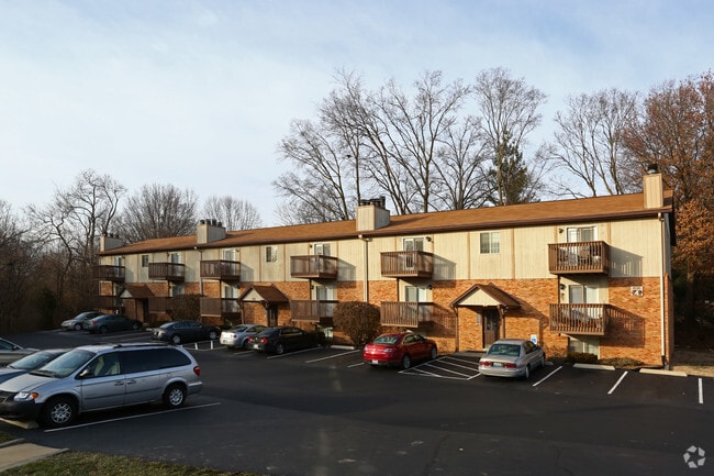

This Property Is For Sale
NEARBY LISTINGS FOR SALE OR LEASE
Property Detail
1837 Lebanon Ave
St. Louis
St Clair Twp
St. Louis, MO-IL
ST CLAIR TWP SEC 14 LOT/SEC-14-SUBL/TWP-1N-BLK/RG-8W PT OF LOTS 26 & 27 A02438560
08-14.0-103-021
St. Clair
Apartment
Illinois
2024
26,27
2024
2.56 AC
503323
Belleville
4,400 SF
DEMOGRAPHICS near 1837 Lebanon Ave
1 Mile
3 Mile
5 Mile
2024 Total Population
7,344
60,698
110,587
2029 Population
7,070
58,776
106,780
Pop Growth 2024-2029
(3.73%)
(3.17%)
(3.44%)
Average Age
42
40
40
2024 Total Households
3,174
25,472
46,380
HH Growth 2024-2029
(3.65%)
(3.18%)
(3.43%)
Median Household Inc
$75,331
$72,701
$74,044
Avg Household Size
2.30
2.30
2.30
2024 Avg HH Vehicles
2.00
2.00
2.00
Median Home Value
$171,118
$164,552
$165,092
Median Year Built
1978
1979
1978
Nearby Places
Map Layers
Map Styles
 Street
 Aerial
- Restaurants
- Banks
- Shops
- Fitness
- Groceries
PUBLIC TRANSPORTATION
COMMUTER RAIL
Belleville (Lambert Airport Shiloh-Scott - St. Louis MetroLink (MetroLink))
DRIVE
WALK
Distance
Belleville (Lambert Airport Shiloh-Scott - St. Louis MetroLink (MetroLink))
4 min
1.7 mi
Swansea (Lambert Airport Shiloh-Scott - St. Louis MetroLink (MetroLink))
DRIVE
WALK
Distance
Swansea (Lambert Airport Shiloh-Scott - St. Louis MetroLink (MetroLink))
4 min
2.1 mi
AIRPORT
Scott AFB/Midamerica St Louis
DRIVE
WALK
Distance
Scott AFB/Midamerica St Louis
21 min
9.6 mi
St Louis Lambert International
DRIVE
WALK
Distance
St Louis Lambert International
46 min
31.7 mi
Freight Ports
Port Milwaukee
DRIVE
WALK
Distance
Port Milwaukee
421 min
368.6 mi
Nearby Properties
Address
Land Use
TOTAL SIZE
Lot Size
Zoning
Address
Land Use
TOTAL SIZE
Lot Size
Zoning
70,515 SF
27.95 AC
Address
Land Use
TOTAL SIZE
Lot Size
Zoning
21.84 AC
Address
Land Use
TOTAL SIZE
Lot Size
Zoning
Address
Land Use
TOTAL SIZE
Lot Size
Zoning
9,384 SF
15.93 AC
Address
Land Use
TOTAL SIZE
Lot Size
Zoning
2,484 SF
16.76 AC
Address
Land Use
TOTAL SIZE
Lot Size
Zoning
2,937 SF
16.68 AC
Address
Land Use
TOTAL SIZE
Lot Size
Zoning
3,388 SF
22.25 AC
Address
Land Use
TOTAL SIZE
Lot Size
Zoning
20,522 SF
6.42 AC
Address
Land Use
TOTAL SIZE
Lot Size
Zoning
217,542 SF
17.71 AC
Address
Land Use
TOTAL SIZE
Lot Size
Zoning
17,676 SF
3.09 AC
Address
Land Use
TOTAL SIZE
Lot Size
Zoning
30.86 AC
Address
Land Use
TOTAL SIZE
Lot Size
Zoning
167,235 SF
18.91 AC
Address
Land Use
TOTAL SIZE
Lot Size
Zoning
41,366 SF
12.07 AC
Address
Land Use
TOTAL SIZE
Lot Size
Zoning
139,172 SF
15.78 AC
Address
Land Use
TOTAL SIZE
Lot Size
Zoning
127,251 SF
12.15 AC
Address
Land Use
TOTAL SIZE
Lot Size
Zoning
Address
Land Use
TOTAL SIZE
Lot Size
Zoning
7,004 SF
9.59 AC
Address
Land Use
TOTAL SIZE
Lot Size
Zoning
7.82 AC
Address
Land Use
TOTAL SIZE
Lot Size
Zoning
10,014 SF
3.18 AC
Address
Land Use
TOTAL SIZE
Lot Size
Zoning
20.63 AC
Address
Land Use
TOTAL SIZE
Lot Size
Zoning
126,937 SF
11.98 AC
Address
Land Use
TOTAL SIZE
Lot Size
Zoning
5,656 SF
8.65 AC
Address
Land Use
TOTAL SIZE
Lot Size
Zoning
46,610 SF
5.22 AC
Address
Land Use
TOTAL SIZE
Lot Size
Zoning
6,800 SF
4.33 AC
Address
Land Use
TOTAL SIZE
Lot Size
Zoning
86,482 SF
8 AC
Address
Land Use
TOTAL SIZE
Lot Size
Zoning
46,489 SF
3.66 AC
Address
Land Use
TOTAL SIZE
Lot Size
Zoning
127,387 SF
11.49 AC
Address
Land Use
TOTAL SIZE
Lot Size
Zoning
155,488 SF
16.54 AC
Address
Land Use
TOTAL SIZE
Lot Size
Zoning
7,344 SF
3.50 AC
Address
Land Use
TOTAL SIZE
Lot Size
Zoning
3,168 SF
2.10 AC
The World's #1 Commercial Real Estate Marketplace
Connect with us
© 2025 CoStar Group
The information above has been obtained from sources believed reliable. While we do not doubt its accuracy we have not verified it and make no guarantee, warranty or representation about it. It is your responsibility to independently confirm its accuracy and completeness. Any projections, opinions, assumptions, or estimates used are for example only and do not represent the current or future performance of the property. The value of this transaction to you depends on tax and other factors which should be evaluated by your tax, financial, and legal advisors. You and your advisors should conduct a careful, independent investigation of the property to determine to your satisfaction the suitability of the property for your needs.