Property Record
1837 W Frankford Rd, Carrollton, TX 75007
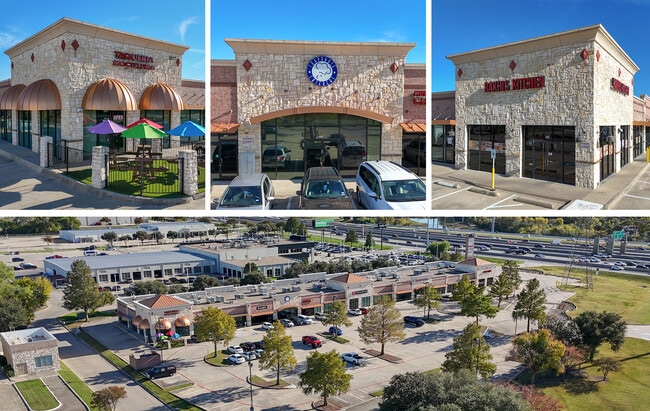

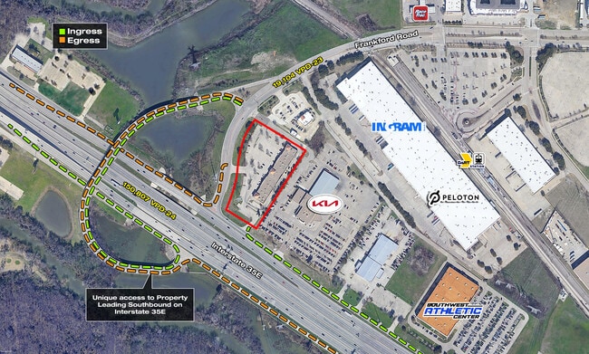

Property Detail
1837 W Frankford Rd
Dallas-Fort Worth-Arlington, TX
UNITED FRANKFORD BLK A LOT 3R(PT)
R243017
DENTON
Commercialnec
Texas
2024
3r
2025
3.89 AC
021621
North Carrollton
30,000 SF
Dallas/Ft Worth
NEARBY LISTINGS FOR SALE OR LEASE
DEMOGRAPHICS near 1837 W Frankford Rd
1 mile
3 mile
5 mile
2025 Total Population
1,429
95,003
290,964
2030 Population
1,659
102,526
313,669
Pop Growth 2025-2030
+ 16.10%
+ 7.92%
+ 7.80%
Average Age
41
39
38
2025 Total Households
558
37,502
110,595
HH Growth 2025-2030
+ 16.13%
+ 8.41%
+ 7.89%
Median Household Inc
$184,642
$106,571
$101,010
Avg Household Size
2.60
2.50
2.60
2025 Avg HH Vehicles
3.00
2.00
2.00
Median Home Value
$466,813
$453,633
$416,165
Median Year Built
1999
1994
1992
Nearby Places
Map Layers
Map Styles
 Street
 Aerial
Transit
 Traffic
 Biking
Places
Listings with unknown addresses are not visible on the map
- Restaurants
- Banks
- Shops
- Fitness
- Groceries
PUBLIC TRANSPORTATION
TRANSIT/SUBWAY
North Carrollton/Frankford Station (Green Line - Dallas Area Rapid Transit (DART))
Drive
Walk
Distance
North Carrollton/Frankford Station (Green Line - Dallas Area Rapid Transit (DART))
3 min
13 min
0.7 mi
COMMUTER RAIL
Drive
Walk
Distance
7 min
2.3 mi
Trinity Mills Station (Green Line - Dallas Area Rapid Transit (DART))
Drive
Walk
Distance
Trinity Mills Station (Green Line - Dallas Area Rapid Transit (DART))
7 min
2.6 mi
AIRPORT
Dallas-Fort Worth International
Drive
Walk
Distance
Dallas-Fort Worth International
17 min
12.1 mi
Dallas Love Field
Drive
Walk
Distance
Dallas Love Field
26 min
16.3 mi
SALE & LEASE HISTORY
LISTING DATE
SALE/LEASE

Sep 24, 2016
For Lease
May 09, 2017
For Lease
May 02, 2018
For Sale
Jun 27, 2017
For Lease
Jul 12, 2021
For Lease
Jul 09, 2019
For Lease
Dec 16, 2024
For Sale
Apr 21, 2017
For Sale
Nearby Properties
Address
Land Use
TOTAL SIZE
Lot Size
Zoning
Address
Land Use
TOTAL SIZE
Lot Size
Zoning
660,180 SF
29.95 AC
Address
Land Use
TOTAL SIZE
Lot Size
Zoning
462,692 SF
30.77 AC
2G
Address
Land Use
TOTAL SIZE
Lot Size
Zoning
452,167 SF
5.80 AC
Address
Land Use
TOTAL SIZE
Lot Size
Zoning
242,707 SF
27.63 AC
Z343
Address
Land Use
TOTAL SIZE
Lot Size
Zoning
352,209 SF
17.54 AC
Z172
Address
Land Use
TOTAL SIZE
Lot Size
Zoning
368,845 SF
20.96 AC
Z172
Address
Land Use
TOTAL SIZE
Lot Size
Zoning
385,247 SF
22.59 AC
3B
Address
Land Use
TOTAL SIZE
Lot Size
Zoning
344,868 SF
19.44 AC
Address
Land Use
TOTAL SIZE
Lot Size
Zoning
514,192 SF
21.56 AC
3B
Address
Land Use
TOTAL SIZE
Lot Size
Zoning
412,389 SF
16.69 AC
3B
Address
Land Use
TOTAL SIZE
Lot Size
Zoning
343,234 SF
32.41 AC
Address
Land Use
TOTAL SIZE
Lot Size
Zoning
354,546 SF
19.38 AC
3B
Address
Land Use
TOTAL SIZE
Lot Size
Zoning
345,320 SF
20.50 AC
Z172
Address
Land Use
TOTAL SIZE
Lot Size
Zoning
424,064 SF
22.15 AC
2B
Address
Land Use
TOTAL SIZE
Lot Size
Zoning
344,926 SF
19.93 AC
3B
Address
Land Use
TOTAL SIZE
Lot Size
Zoning
725,972 SF
4 AC
Address
Land Use
TOTAL SIZE
Lot Size
Zoning
189,500 SF
53.90 AC
Address
Land Use
TOTAL SIZE
Lot Size
Zoning
347,181 SF
18.51 AC
3B
Address
Land Use
TOTAL SIZE
Lot Size
Zoning
392,646 SF
19.65 AC
3B
Address
Land Use
TOTAL SIZE
Lot Size
Zoning
297,932 SF
14.05 AC
Address
Land Use
TOTAL SIZE
Lot Size
Zoning
283,285 SF
16.80 AC
Z172
Address
Land Use
TOTAL SIZE
Lot Size
Zoning
330,816 SF
14.97 AC
Address
Land Use
TOTAL SIZE
Lot Size
Zoning
315,084 SF
13.76 AC
3B
Address
Land Use
TOTAL SIZE
Lot Size
Zoning
659,218 SF
34.29 AC
Address
Land Use
TOTAL SIZE
Lot Size
Zoning
251,650 SF
14.22 AC
Address
Land Use
TOTAL SIZE
Lot Size
Zoning
318,477 SF
18.79 AC
Address
Land Use
TOTAL SIZE
Lot Size
Zoning
300,958 SF
16.61 AC
Address
Land Use
TOTAL SIZE
Lot Size
Zoning
711,360 SF
32.62 AC
Address
Land Use
TOTAL SIZE
Lot Size
Zoning
350,002 SF
21.01 AC
Z172
Address
Land Use
TOTAL SIZE
Lot Size
Zoning
228,674 SF
11.81 AC
Z235
The World's #1 Commercial Real Estate Marketplace
Connect with us
© 2026 CoStar Group
The information above has been obtained from sources believed reliable. While we do not doubt its accuracy we have not verified it and make no guarantee, warranty or representation about it. It is your responsibility to independently confirm its accuracy and completeness. Any projections, opinions, assumptions, or estimates used are for example only and do not represent the current or future performance of the property. The value of this transaction to you depends on tax and other factors which should be evaluated by your tax, financial, and legal advisors. You and your advisors should conduct a careful, independent investigation of the property to determine to your satisfaction the suitability of the property for your needs.