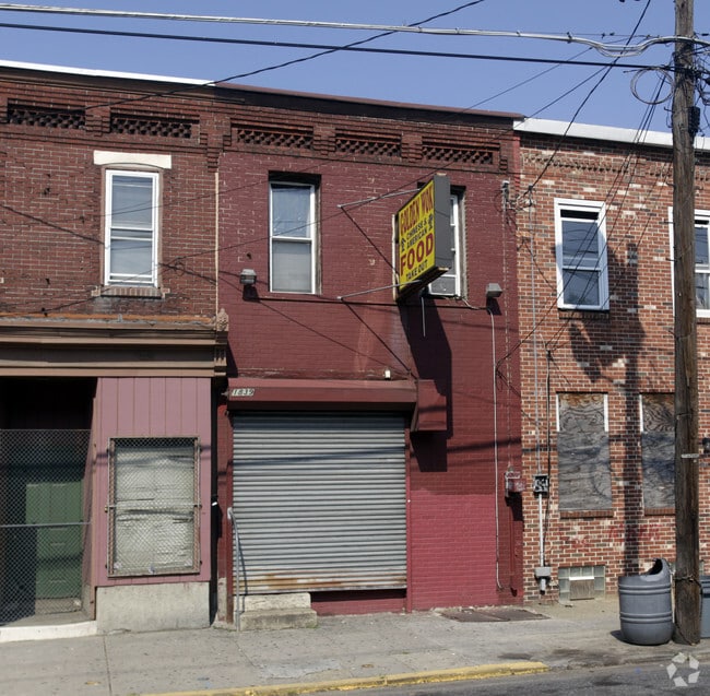
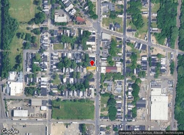
Property Record
1839 S Broadway, Camden, NJ 08104

NEARBY LISTINGS FOR SALE OR LEASE
Property Detail
1839 S Broadway
08-00482-0000-00076
Camden
Commercialnec
New Jersey
X
76
34007C0036F
0.03 AC
2024
North Camden County
2025
Philadelphia
601800
Philadelphia-Camden-Wilmington, PA-NJ-DE-MD
1,608 SF
DEMOGRAPHICS near 1839 S Broadway
1 Mile
3 Mile
5 Mile
2024 Total Population
15,743
248,785
670,570
2029 Population
16,294
244,527
661,676
Pop Growth 2024-2029
+ 3.50%
(1.71%)
(1.33%)
Average Age
34
38
37
2024 Total Households
5,716
104,820
284,159
HH Growth 2024-2029
+ 3.60%
(2.10%)
(1.68%)
Median Household Inc
$24,412
$67,423
$70,971
Avg Household Size
2.70
2.30
2.20
2024 Avg HH Vehicles
1.00
1.00
1.00
Median Home Value
$96,084
$286,525
$293,666
Median Year Built
1955
1948
1950
Nearby Places
Map Layers
Map Styles
 Street
 Aerial
- Restaurants
- Banks
- Shops
- Fitness
- Groceries
PUBLIC TRANSPORTATION
COMMUTER RAIL
Market East (R1 - Southeastern Pennsylvania Transportation Authority Regional Rail (SEPTA Regional Rail), R2 - Southeastern Pennsylvania Transportation Authority Regional Rail (SEPTA Regional Rail), R3 - Southeastern Pennsylvania Transportation Authority Regional Rail (SEPTA Regional Rail), R5 - Southeastern Pennsylvania Transportation Authority Regional Rail (SEPTA Regional Rail), R6 - Southeastern Pennsylvania Transportation Authority Regional Rail (SEPTA Regional Rail), R7 - Southeastern Pennsylvania Transportation Authority Regional Rail (SEPTA Regional Rail), R8 - Southeastern Pennsylvania Transportation Authority Regional Rail (SEPTA Regional Rail))
DRIVE
WALK
Distance
Market East (R1 - Southeastern Pennsylvania Transportation Authority Regional Rail (SEPTA Regional Rail), R2 - Southeastern Pennsylvania Transportation Authority Regional Rail (SEPTA Regional Rail), R3 - Southeastern Pennsylvania Transportation Authority Regional Rail (SEPTA Regional Rail), R5 - Southeastern Pennsylvania Transportation Authority Regional Rail (SEPTA Regional Rail), R6 - Southeastern Pennsylvania Transportation Authority Regional Rail (SEPTA Regional Rail), R7 - Southeastern Pennsylvania Transportation Authority Regional Rail (SEPTA Regional Rail), R8 - Southeastern Pennsylvania Transportation Authority Regional Rail (SEPTA Regional Rail))
10 min
5.2 mi
Cherry Hill (Atlantic City Line - NJ Transit Commuter Rail (NJ Transit))
DRIVE
WALK
Distance
Cherry Hill (Atlantic City Line - NJ Transit Commuter Rail (NJ Transit))
11 min
5.5 mi
AIRPORT
Philadelphia International
DRIVE
WALK
Distance
Philadelphia International
22 min
11.4 mi
Trenton Mercer
DRIVE
WALK
Distance
Trenton Mercer
55 min
37.0 mi
Atlantic City International
DRIVE
WALK
Distance
Atlantic City International
81 min
49.9 mi
Freight Ports
Broadway Terminal - Pier 5
DRIVE
WALK
Distance
Broadway Terminal - Pier 5
3 min
1.1 mi
Nearby Properties
Address
Land Use
TOTAL SIZE
Lot Size
Zoning
Address
Land Use
TOTAL SIZE
Lot Size
Zoning
608,400 SF
43.23 AC
SPSTA
Address
Land Use
TOTAL SIZE
Lot Size
Zoning
11,513 SF
19.92 AC
SPSTA
Address
Land Use
TOTAL SIZE
Lot Size
Zoning
159,630 SF
9.15 AC
SPENT
Address
Land Use
TOTAL SIZE
Lot Size
Zoning
1.17 AC
Address
Land Use
TOTAL SIZE
Lot Size
Zoning
7.17 AC
Address
Land Use
TOTAL SIZE
Lot Size
Zoning
738,750 SF
1.19 AC
CMX5
Address
Land Use
TOTAL SIZE
Lot Size
Zoning
1,102,992 SF
2.14 AC
CMX5
Address
Land Use
TOTAL SIZE
Lot Size
Zoning
665,742 SF
0.98 AC
CMX4
Address
Land Use
TOTAL SIZE
Lot Size
Zoning
124.13 AC
Address
Land Use
TOTAL SIZE
Lot Size
Zoning
1,011,079 SF
5.82 AC
CMX5
Address
Land Use
TOTAL SIZE
Lot Size
Zoning
63,402 SF
0.71 AC
CMX4
Address
Land Use
TOTAL SIZE
Lot Size
Zoning
723,780 SF
1.15 AC
CMX5
Address
Land Use
TOTAL SIZE
Lot Size
Zoning
Address
Land Use
TOTAL SIZE
Lot Size
Zoning
80,064 SF
51.52 AC
I3
Address
Land Use
TOTAL SIZE
Lot Size
Zoning
747,200 SF
0.69 AC
CMX5
Address
Land Use
TOTAL SIZE
Lot Size
Zoning
12.53 AC
Address
Land Use
TOTAL SIZE
Lot Size
Zoning
139,992 SF
5.64 AC
SPPOA
Address
Land Use
TOTAL SIZE
Lot Size
Zoning
458,809 SF
3.37 AC
CMX3
Address
Land Use
TOTAL SIZE
Lot Size
Zoning
322,000 SF
7.44 AC
CMX3
Address
Land Use
TOTAL SIZE
Lot Size
Zoning
816,208 SF
2.98 AC
CMX4
Address
Land Use
TOTAL SIZE
Lot Size
Zoning
449,820 SF
0.42 AC
CMX5
Address
Land Use
TOTAL SIZE
Lot Size
Zoning
213,823 SF
2.01 AC
CMX5
Address
Land Use
TOTAL SIZE
Lot Size
Zoning
1.62 AC
Address
Land Use
TOTAL SIZE
Lot Size
Zoning
332,444 SF
1.32 AC
CMX3
Address
Land Use
TOTAL SIZE
Lot Size
Zoning
169,220 SF
2.01 AC
SPINS
Address
Land Use
TOTAL SIZE
Lot Size
Zoning
256,688 SF
1.46 AC
RMX3
Address
Land Use
TOTAL SIZE
Lot Size
Zoning
447,070 SF
0.78 AC
CMX5
Address
Land Use
TOTAL SIZE
Lot Size
Zoning
693,000 SF
1.28 AC
CMX5
Address
Land Use
TOTAL SIZE
Lot Size
Zoning
986,960 SF
1.61 AC
CMX4
Address
Land Use
TOTAL SIZE
Lot Size
Zoning
631,006 SF
0.93 AC
CMX5
The World's #1 Commercial Real Estate Marketplace
Connect with us
© 2025 CoStar Group
The information above has been obtained from sources believed reliable. While we do not doubt its accuracy we have not verified it and make no guarantee, warranty or representation about it. It is your responsibility to independently confirm its accuracy and completeness. Any projections, opinions, assumptions, or estimates used are for example only and do not represent the current or future performance of the property. The value of this transaction to you depends on tax and other factors which should be evaluated by your tax, financial, and legal advisors. You and your advisors should conduct a careful, independent investigation of the property to determine to your satisfaction the suitability of the property for your needs.