Property Record
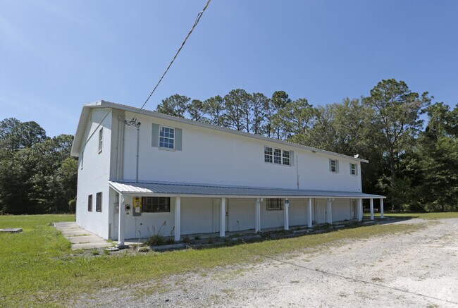
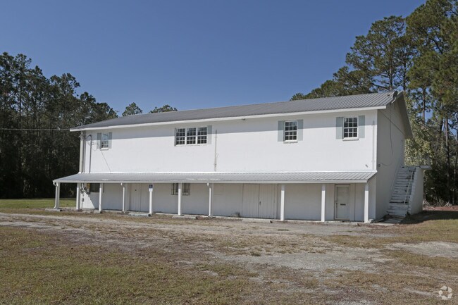
18392 Us Highway 301 N, Starke, FL 32091

Property Detail
18392 Us Highway 301 N
02101-0-00000
10 6S 22 COM SW COR OF SW1/4 OF SW1/4. N358.6 FOR POB. N280, SELY 234.75 TO W R/W SR-200, RUN S32*W 280, W76.4 TO POB. BEING .90 ACRE M/L. ALSO ANY PORTION THAT MAY LYE W/IN FOLLOWING COM SE COR OF SE1/4 OF SE1/4 S89*0038W 37.03, LOCATED NWLY R/W 301
Commercialnec
Bradford
A Areas with a 1% annual chance of flooding and a 26% chance of flooding over the life of a 30-year mortgage.
Florida
2025
2.10 AC
2025
Florida Central North Area
000202
Other Market Areas
7,116 SF
NEARBY LISTINGS FOR SALE OR LEASE
-
-
View all Starke listings for sale on LoopNet.com
DEMOGRAPHICS near 18392 Us Highway 301 N
1 mile
3 mile
5 mile
2025 Total Population
522
7,281
14,858
2030 Population
551
7,747
15,729
Pop Growth 2025-2030
+ 5.56%
+ 6.40%
+ 5.86%
Average Age
42
41
42
2025 Total Households
178
2,733
5,418
HH Growth 2025-2030
+ 6.74%
+ 5.96%
+ 5.92%
Median Household Inc
$60,536
$50,340
$57,605
Avg Household Size
2.60
2.60
2.50
2025 Avg HH Vehicles
2.00
2.00
2.00
Median Home Value
$210,869
$217,011
$204,803
Median Year Built
1984
1983
1984
Nearby Places
Map Layers
Map Styles
 Street
 Aerial
Layers
 Traffic
 Biking
Places
Listings with unknown addresses are not visible on the map
- Restaurants
- Banks
- Shops
- Fitness
- Groceries
PUBLIC TRANSPORTATION
AIRPORT
Gainesville Regional
Drive
Walk
Distance
Gainesville Regional
41 min
28.6 mi
Freight Ports
Jacksonville Port
Drive
Walk
Distance
Jacksonville Port
61 min
46.4 mi
SALE & LEASE HISTORY
LISTING DATE
SALE/LEASE

May 07, 2018
For Sale
Nearby Properties
Address
Land Use
TOTAL SIZE
Lot Size
Zoning
Address
Land Use
TOTAL SIZE
Lot Size
Zoning
96,617 SF
11 AC
Address
Land Use
TOTAL SIZE
Lot Size
Zoning
63,568 SF
8.54 AC
Address
Land Use
TOTAL SIZE
Lot Size
Zoning
117,119 SF
30.15 AC
Address
Land Use
TOTAL SIZE
Lot Size
Zoning
64,054 SF
4.07 AC
Address
Land Use
TOTAL SIZE
Lot Size
Zoning
119,949 SF
5.50 AC
Address
Land Use
TOTAL SIZE
Lot Size
Zoning
35,032 SF
8.75 AC
Address
Land Use
TOTAL SIZE
Lot Size
Zoning
30,963 SF
7.47 AC
Address
Land Use
TOTAL SIZE
Lot Size
Zoning
111,635 SF
44.63 AC
Address
Land Use
TOTAL SIZE
Lot Size
Zoning
42,534 SF
1.86 AC
Address
Land Use
TOTAL SIZE
Lot Size
Zoning
29,120 SF
3.26 AC
Address
Land Use
TOTAL SIZE
Lot Size
Zoning
15,287 SF
1.54 AC
Address
Land Use
TOTAL SIZE
Lot Size
Zoning
63.28 AC
Address
Land Use
TOTAL SIZE
Lot Size
Zoning
16,274 SF
1.51 AC
Address
Land Use
TOTAL SIZE
Lot Size
Zoning
35,950 SF
2.76 AC
Address
Land Use
TOTAL SIZE
Lot Size
Zoning
22,052 SF
2.67 AC
Address
Land Use
TOTAL SIZE
Lot Size
Zoning
14,806 SF
6.80 AC
Address
Land Use
TOTAL SIZE
Lot Size
Zoning
16,890 SF
12.64 AC
Address
Land Use
TOTAL SIZE
Lot Size
Zoning
15,926 SF
1.41 AC
Address
Land Use
TOTAL SIZE
Lot Size
Zoning
23,220 SF
2.41 AC
Address
Land Use
TOTAL SIZE
Lot Size
Zoning
33,282 SF
20 AC
Address
Land Use
TOTAL SIZE
Lot Size
Zoning
18,480 SF
10.83 AC
Address
Land Use
TOTAL SIZE
Lot Size
Zoning
49,871 SF
3 AC
Address
Land Use
TOTAL SIZE
Lot Size
Zoning
27,176 SF
13.75 AC
Address
Land Use
TOTAL SIZE
Lot Size
Zoning
10,645 SF
1.33 AC
Address
Land Use
TOTAL SIZE
Lot Size
Zoning
17,764 SF
1.39 AC
Address
Land Use
TOTAL SIZE
Lot Size
Zoning
15,040 SF
0.68 AC
Address
Land Use
TOTAL SIZE
Lot Size
Zoning
31,132 SF
4 AC
Address
Land Use
TOTAL SIZE
Lot Size
Zoning
30,612 SF
6.09 AC
Address
Land Use
TOTAL SIZE
Lot Size
Zoning
370 AC
Address
Land Use
TOTAL SIZE
Lot Size
Zoning
9,576 SF
2.17 AC
The World's #1 Commercial Real Estate Marketplace
Connect with us
© 2026 CoStar Group
The information above has been obtained from sources believed reliable. While we do not doubt its accuracy we have not verified it and make no guarantee, warranty or representation about it. It is your responsibility to independently confirm its accuracy and completeness. Any projections, opinions, assumptions, or estimates used are for example only and do not represent the current or future performance of the property. The value of this transaction to you depends on tax and other factors which should be evaluated by your tax, financial, and legal advisors. You and your advisors should conduct a careful, independent investigation of the property to determine to your satisfaction the suitability of the property for your needs.