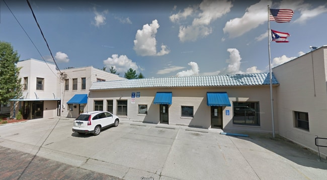
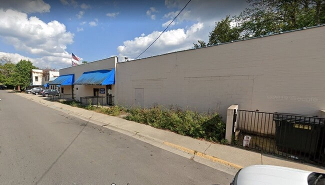
Property Record
184 N Lancaster St, Athens, OH 45701
Current Lease Availabilities
Property Detail
184 N Lancaster St
A02-81700041-00
IL 1698 PP L-22 6 1/2 STRIP N SIDE
Officebuilding
ATHENS
B and X Area of moderate flood hazard, usually the area between the limits of the 100-year and 500-year floods.
Ohio
2025
0.17 AC
2025
Ohio South Area
973901
Other Market Areas
882 SF
Athens, OH
NEARBY LISTINGS FOR SALE OR LEASE
DEMOGRAPHICS near 184 N Lancaster St
1 mile
3 mile
5 mile
2025 Total Population
17,458
28,152
35,042
2030 Population
17,604
28,278
35,143
Pop Growth 2025-2030
+ 0.84%
+ 0.45%
+ 0.29%
Average Age
27
31
33
2025 Total Households
4,719
9,122
12,159
HH Growth 2025-2030
+ 0.78%
+ 0.20%
+ 0.13%
Median Household Inc
$31,921
$39,382
$46,615
Avg Household Size
2.10
2.10
2.20
2025 Avg HH Vehicles
1.00
2.00
2.00
Median Home Value
$240,561
$252,596
$254,632
Median Year Built
1967
1977
1978
Nearby Places
Map Layers
Map Styles
 Street
 Aerial
Layers
 Traffic
 Biking
Places
Listings with unknown addresses are not visible on the map
- Restaurants
- Banks
- Shops
- Fitness
- Groceries
Nearby Properties
Address
Land Use
TOTAL SIZE
Lot Size
Zoning
Address
Land Use
TOTAL SIZE
Lot Size
Zoning
0.30 AC
Address
Land Use
TOTAL SIZE
Lot Size
Zoning
157,323 SF
100.28 AC
Address
Land Use
TOTAL SIZE
Lot Size
Zoning
101,760 SF
11.62 AC
Address
Land Use
TOTAL SIZE
Lot Size
Zoning
357,956 SF
1.84 AC
Address
Land Use
TOTAL SIZE
Lot Size
Zoning
8,769 SF
33.83 AC
Address
Land Use
TOTAL SIZE
Lot Size
Zoning
128,165 SF
0.17 AC
Address
Land Use
TOTAL SIZE
Lot Size
Zoning
329,244 SF
Address
Land Use
TOTAL SIZE
Lot Size
Zoning
10.06 AC
Address
Land Use
TOTAL SIZE
Lot Size
Zoning
20.35 AC
Address
Land Use
TOTAL SIZE
Lot Size
Zoning
22 AC
Address
Land Use
TOTAL SIZE
Lot Size
Zoning
9.80 AC
Address
Land Use
TOTAL SIZE
Lot Size
Zoning
191,801 SF
3 AC
Address
Land Use
TOTAL SIZE
Lot Size
Zoning
43,469 SF
4.78 AC
Address
Land Use
TOTAL SIZE
Lot Size
Zoning
Address
Land Use
TOTAL SIZE
Lot Size
Zoning
150,578 SF
2.59 AC
Address
Land Use
TOTAL SIZE
Lot Size
Zoning
169,832 SF
0.49 AC
Address
Land Use
TOTAL SIZE
Lot Size
Zoning
117,143 SF
0.93 AC
Address
Land Use
TOTAL SIZE
Lot Size
Zoning
114,857 SF
0.48 AC
Address
Land Use
TOTAL SIZE
Lot Size
Zoning
24.23 AC
Address
Land Use
TOTAL SIZE
Lot Size
Zoning
2,004 SF
1.09 AC
Address
Land Use
TOTAL SIZE
Lot Size
Zoning
158,696 SF
12 AC
Address
Land Use
TOTAL SIZE
Lot Size
Zoning
113,828 SF
0.71 AC
Address
Land Use
TOTAL SIZE
Lot Size
Zoning
116,023 SF
0.85 AC
Address
Land Use
TOTAL SIZE
Lot Size
Zoning
99,964 SF
1.04 AC
Address
Land Use
TOTAL SIZE
Lot Size
Zoning
5,675 SF
8.11 AC
Address
Land Use
TOTAL SIZE
Lot Size
Zoning
1,485 SF
23.99 AC
Address
Land Use
TOTAL SIZE
Lot Size
Zoning
183,602 SF
0.04 AC
Address
Land Use
TOTAL SIZE
Lot Size
Zoning
3,016 SF
101.48 AC
Address
Land Use
TOTAL SIZE
Lot Size
Zoning
7.25 AC
Address
Land Use
TOTAL SIZE
Lot Size
Zoning
127,035 SF
0.55 AC
The World's #1 Commercial Real Estate Marketplace
Connect with us
© 2026 CoStar Group
The information above has been obtained from sources believed reliable. While we do not doubt its accuracy we have not verified it and make no guarantee, warranty or representation about it. It is your responsibility to independently confirm its accuracy and completeness. Any projections, opinions, assumptions, or estimates used are for example only and do not represent the current or future performance of the property. The value of this transaction to you depends on tax and other factors which should be evaluated by your tax, financial, and legal advisors. You and your advisors should conduct a careful, independent investigation of the property to determine to your satisfaction the suitability of the property for your needs.