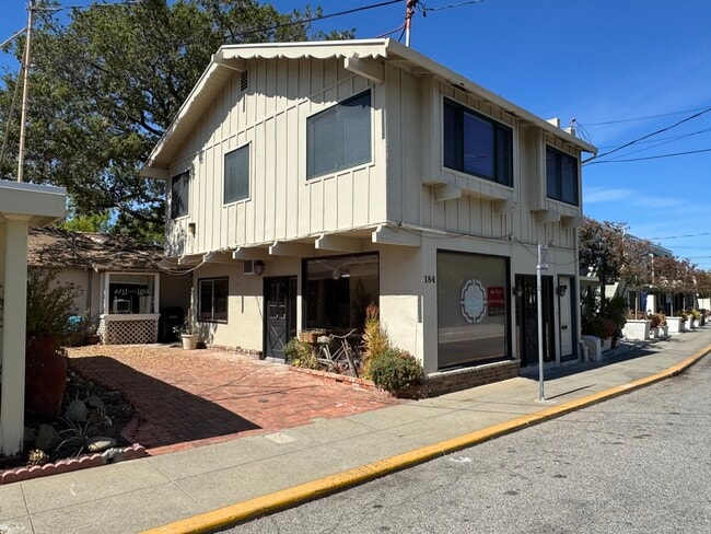
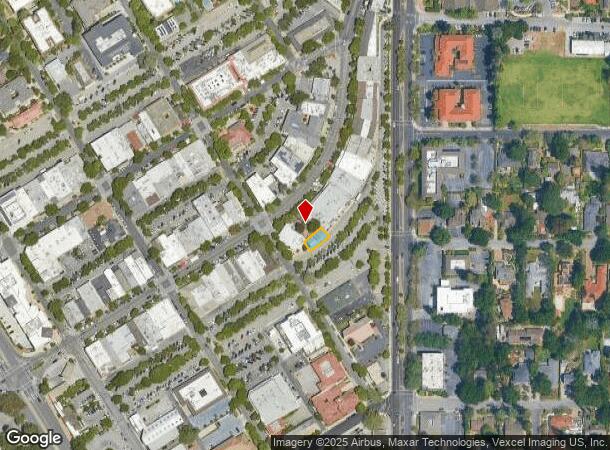
Property Record
189 Main St, Los Altos, CA 94022
Current Lease Availabilities
NEARBY LISTINGS FOR SALE OR LEASE
Property Detail
189 Main St
167-38-053
Record Survey Por Lot2 Blk2 Map #1 Town
Storebuilding
LOT B RECORDERS BOOK 154 PAGE 21
X
Santa Clara
06085C0038H
California
2024
0.05 AC
2025
Los Altos
510300
South Bay/San Jose
1,410 SF
San Jose-Sunnyvale-Santa Clara, CA
DEMOGRAPHICS near 189 Main St
1 Mile
3 Mile
5 Mile
2024 Total Population
12,505
134,592
291,286
2029 Population
12,873
139,552
300,833
Pop Growth 2024-2029
+ 2.94%
+ 3.69%
+ 3.28%
Average Age
45
41
40
2024 Total Households
4,424
52,811
107,812
HH Growth 2024-2029
+ 2.96%
+ 3.80%
+ 3.43%
Median Household Inc
$242,730
$203,622
$196,468
Avg Household Size
2.80
2.50
2.50
2024 Avg HH Vehicles
2.00
2.00
2.00
Median Home Value
$1,141,063
$1,133,074
$1,133,986
Median Year Built
1964
1971
1971
Nearby Places
- Restaurants
- Banks
- Shops
- Fitness
- Groceries
PUBLIC TRANSPORTATION
COMMUTER RAIL
San Antonio (Caltrain - Caltrain (Caltrain))
DRIVE
WALK
Distance
San Antonio (Caltrain - Caltrain (Caltrain))
5 min
2.3 mi
DRIVE
WALK
Distance
9 min
3.3 mi
AIRPORT
Norman Y Mineta San Jose International
DRIVE
WALK
Distance
Norman Y Mineta San Jose International
22 min
12.4 mi
San Francisco International
DRIVE
WALK
Distance
San Francisco International
36 min
25.9 mi
Metro Oakland International
DRIVE
WALK
Distance
Metro Oakland International
50 min
34.6 mi
Freight Ports
Port of Redwood City
DRIVE
WALK
Distance
Port of Redwood City
21 min
12.8 mi
Nearby Properties
Address
Land Use
TOTAL SIZE
Lot Size
Zoning
Address
Land Use
TOTAL SIZE
Lot Size
Zoning
42.28 AC
PF
Address
Land Use
TOTAL SIZE
Lot Size
Zoning
0.33 AC
PF
Address
Land Use
TOTAL SIZE
Lot Size
Zoning
450,575 SF
3.73 AC
P(9)
Address
Land Use
TOTAL SIZE
Lot Size
Zoning
78,277 SF
16.31 AC
RP
Address
Land Use
TOTAL SIZE
Lot Size
Zoning
584,389 SF
5.25 AC
P(40)
Address
Land Use
TOTAL SIZE
Lot Size
Zoning
595,000 SF
7.42 AC
P(34)
Address
Land Use
TOTAL SIZE
Lot Size
Zoning
675,100 SF
52.78 AC
RP5
Address
Land Use
TOTAL SIZE
Lot Size
Zoning
233,124 SF
9.18 AC
P(7)
Address
Land Use
TOTAL SIZE
Lot Size
Zoning
458,842 SF
26.64 AC
RP5
Address
Land Use
TOTAL SIZE
Lot Size
Zoning
372,859 SF
4.71 AC
P
Address
Land Use
TOTAL SIZE
Lot Size
Zoning
298,463 SF
7 AC
P(19)
Address
Land Use
TOTAL SIZE
Lot Size
Zoning
640,105 SF
7.90 AC
R3-2*
Address
Land Use
TOTAL SIZE
Lot Size
Zoning
521,754 SF
46.72 AC
RP
Address
Land Use
TOTAL SIZE
Lot Size
Zoning
322,264 SF
3.92 AC
P
Address
Land Use
TOTAL SIZE
Lot Size
Zoning
208.82 AC
MV
Address
Land Use
TOTAL SIZE
Lot Size
Zoning
110,384 SF
10.17 AC
RP
Address
Land Use
TOTAL SIZE
Lot Size
Zoning
89,237 SF
5.51 AC
P(9)
Address
Land Use
TOTAL SIZE
Lot Size
Zoning
516,963 SF
36.46 AC
RP
Address
Land Use
TOTAL SIZE
Lot Size
Zoning
224,086 SF
10.80 AC
R3-1.
Address
Land Use
TOTAL SIZE
Lot Size
Zoning
2.90 AC
P(17)
Address
Land Use
TOTAL SIZE
Lot Size
Zoning
162,552 SF
9.78 AC
R3-2*
Address
Land Use
TOTAL SIZE
Lot Size
Zoning
129,678 SF
7.17 AC
LMS
Address
Land Use
TOTAL SIZE
Lot Size
Zoning
35,926 SF
6.50 AC
RP5
Address
Land Use
TOTAL SIZE
Lot Size
Zoning
96,579 SF
1.21 AC
P(19)
Address
Land Use
TOTAL SIZE
Lot Size
Zoning
111,443 SF
1.81 AC
ML
Address
Land Use
TOTAL SIZE
Lot Size
Zoning
161,432 SF
13.72 AC
RP
Address
Land Use
TOTAL SIZE
Lot Size
Zoning
186,490 SF
2.43 AC
CRA
Address
Land Use
TOTAL SIZE
Lot Size
Zoning
114,809 SF
3.94 AC
P18
Address
Land Use
TOTAL SIZE
Lot Size
Zoning
227,390 SF
2.28 AC
P(38)
Address
Land Use
TOTAL SIZE
Lot Size
Zoning
207,857 SF
16.34 AC
RP-5D
The World's #1 Commercial Real Estate Marketplace
Connect with us
© 2025 CoStar Group
The information above has been obtained from sources believed reliable. While we do not doubt its accuracy we have not verified it and make no guarantee, warranty or representation about it. It is your responsibility to independently confirm its accuracy and completeness. Any projections, opinions, assumptions, or estimates used are for example only and do not represent the current or future performance of the property. The value of this transaction to you depends on tax and other factors which should be evaluated by your tax, financial, and legal advisors. You and your advisors should conduct a careful, independent investigation of the property to determine to your satisfaction the suitability of the property for your needs.