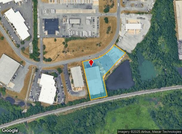
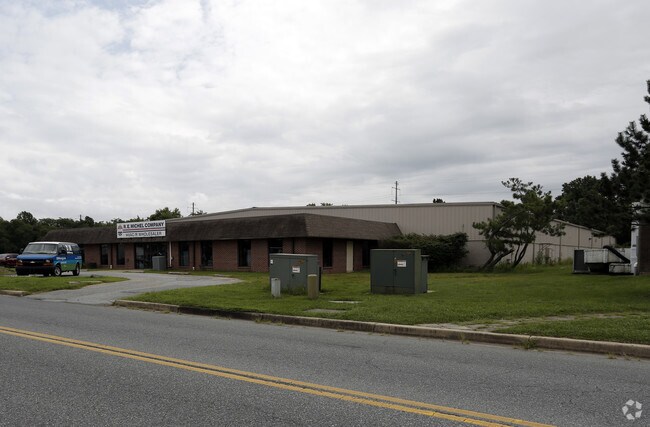
Property Record
184 Quigley Blvd, Historic New Castle, DE 19720


NEARBY LISTINGS FOR SALE OR LEASE
Property Detail
184 Quigley Blvd
10-030.00-060
Airport Ind Park
Officebuilding
New Castle
AE
Delaware
10003C0161L
2.50 AC
2024
New Castle County
2024
Philadelphia
016309
Philadelphia-Camden-Wilmington, PA-NJ-DE-MD
8,120 SF
DEMOGRAPHICS near 184 Quigley Blvd
1 Mile
3 Mile
5 Mile
2024 Total Population
1,946
48,582
121,623
2029 Population
2,035
49,216
123,061
Pop Growth 2024-2029
+ 4.57%
+ 1.31%
+ 1.18%
Average Age
41
40
40
2024 Total Households
734
19,264
47,341
HH Growth 2024-2029
+ 4.63%
+ 1.34%
+ 1.22%
Median Household Inc
$80,134
$64,345
$67,267
Avg Household Size
2.60
2.50
2.50
2024 Avg HH Vehicles
2.00
2.00
2.00
Median Home Value
$251,242
$231,808
$226,830
Median Year Built
1966
1972
1973
Nearby Places
Map Layers
Map Styles
 Street
 Aerial
- Restaurants
- Banks
- Shops
- Fitness
- Groceries
PUBLIC TRANSPORTATION
COMMUTER RAIL
Churchmans Crossing (R2 - Southeastern Pennsylvania Transportation Authority Regional Rail (SEPTA Regional Rail))
DRIVE
WALK
Distance
Churchmans Crossing (R2 - Southeastern Pennsylvania Transportation Authority Regional Rail (SEPTA Regional Rail))
9 min
5.3 mi
Wilmington (R2 - Southeastern Pennsylvania Transportation Authority Regional Rail (SEPTA Regional Rail))
DRIVE
WALK
Distance
Wilmington (R2 - Southeastern Pennsylvania Transportation Authority Regional Rail (SEPTA Regional Rail))
13 min
6.8 mi
AIRPORT
Philadelphia International
DRIVE
WALK
Distance
Philadelphia International
39 min
27.2 mi
Freight Ports
Port of Wilmington, RI
DRIVE
WALK
Distance
Port of Wilmington, RI
14 min
7.1 mi
Nearby Properties
Address
Land Use
TOTAL SIZE
Lot Size
Zoning
Address
Land Use
TOTAL SIZE
Lot Size
Zoning
163,588 SF
1,229.95 AC
I
Address
Land Use
TOTAL SIZE
Lot Size
Zoning
324,073 SF
77.78 AC
S
Address
Land Use
TOTAL SIZE
Lot Size
Zoning
326,520 SF
125.02 AC
EX
Address
Land Use
TOTAL SIZE
Lot Size
Zoning
197,726 SF
25 AC
I
Address
Land Use
TOTAL SIZE
Lot Size
Zoning
735,703 SF
49.15 AC
NCAP
Address
Land Use
TOTAL SIZE
Lot Size
Zoning
187,286 SF
24.20 AC
CR
Address
Land Use
TOTAL SIZE
Lot Size
Zoning
76,357 SF
145.10 AC
CR
Address
Land Use
TOTAL SIZE
Lot Size
Zoning
352,104 SF
16.35 AC
BP
Address
Land Use
TOTAL SIZE
Lot Size
Zoning
248,554 SF
18.58 AC
CR
Address
Land Use
TOTAL SIZE
Lot Size
Zoning
51,286 SF
15.60 AC
CR
Address
Land Use
TOTAL SIZE
Lot Size
Zoning
56,352 SF
11.29 AC
I
Address
Land Use
TOTAL SIZE
Lot Size
Zoning
281,611 SF
26.39 AC
NCAP
Address
Land Use
TOTAL SIZE
Lot Size
Zoning
268,661 SF
28.38 AC
NCAP
Address
Land Use
TOTAL SIZE
Lot Size
Zoning
295,200 SF
17.94 AC
NCAP
Address
Land Use
TOTAL SIZE
Lot Size
Zoning
421,754 SF
47.58 AC
21I
Address
Land Use
TOTAL SIZE
Lot Size
Zoning
213,565 SF
11.73 AC
21I
Address
Land Use
TOTAL SIZE
Lot Size
Zoning
3,850 SF
12.43 AC
CR
Address
Land Use
TOTAL SIZE
Lot Size
Zoning
358,315 SF
6.39 AC
BP
Address
Land Use
TOTAL SIZE
Lot Size
Zoning
79,778 SF
8.83 AC
NC6.5
Address
Land Use
TOTAL SIZE
Lot Size
Zoning
388,314 SF
22.06 AC
NCAP
Address
Land Use
TOTAL SIZE
Lot Size
Zoning
30,127 SF
6.53 AC
CR
Address
Land Use
TOTAL SIZE
Lot Size
Zoning
96,676 SF
6.17 AC
BP
Address
Land Use
TOTAL SIZE
Lot Size
Zoning
56,319 SF
I
Address
Land Use
TOTAL SIZE
Lot Size
Zoning
135,764 SF
18.59 AC
NCAP
Address
Land Use
TOTAL SIZE
Lot Size
Zoning
341,694 SF
13.66 AC
HI
Address
Land Use
TOTAL SIZE
Lot Size
Zoning
234,000 SF
15.52 AC
21I
Address
Land Use
TOTAL SIZE
Lot Size
Zoning
225,128 SF
9.47 AC
21I
Address
Land Use
TOTAL SIZE
Lot Size
Zoning
83,500 SF
14.21 AC
BP
Address
Land Use
TOTAL SIZE
Lot Size
Zoning
48,657 SF
10 AC
S
Address
Land Use
TOTAL SIZE
Lot Size
Zoning
61,253 SF
11.87 AC
BP
The World's #1 Commercial Real Estate Marketplace
Connect with us
© 2025 CoStar Group
The information above has been obtained from sources believed reliable. While we do not doubt its accuracy we have not verified it and make no guarantee, warranty or representation about it. It is your responsibility to independently confirm its accuracy and completeness. Any projections, opinions, assumptions, or estimates used are for example only and do not represent the current or future performance of the property. The value of this transaction to you depends on tax and other factors which should be evaluated by your tax, financial, and legal advisors. You and your advisors should conduct a careful, independent investigation of the property to determine to your satisfaction the suitability of the property for your needs.