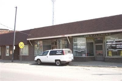
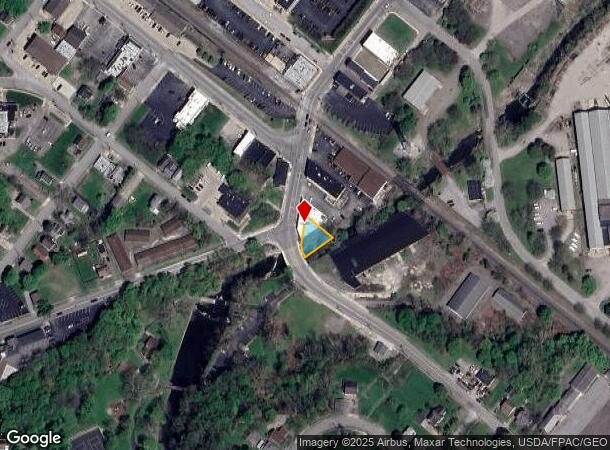
Property Record
184 S Bridge St, Struthers, OH 44471
NEARBY LISTINGS FOR SALE OR LEASE
Property Detail
184 S Bridge St
Youngstown/Warren/Boardman
Bridge
Youngstown-Warren-Boardman, OH-PA
LOT 221 61.8 X 101 IRR BRIDGE
38-005-0-217.00-0
Mahoning
Storebuilding
Ohio
2024
221
2024
0.14 AC
810600
Mahoning County
1,550 SF
DEMOGRAPHICS near 184 S Bridge St
1 Mile
3 Mile
5 Mile
2024 Total Population
7,457
42,314
95,334
2029 Population
7,390
41,619
94,300
Pop Growth 2024-2029
(0.90%)
(1.64%)
(1.08%)
Average Age
39
42
42
2024 Total Households
3,051
18,230
40,414
HH Growth 2024-2029
(0.98%)
(1.72%)
(1.17%)
Median Household Inc
$37,485
$45,542
$42,970
Avg Household Size
2.40
2.30
2.20
2024 Avg HH Vehicles
2.00
2.00
2.00
Median Home Value
$71,729
$95,784
$103,210
Median Year Built
1948
1955
1955
Nearby Places
Map Layers
Map Styles
 Street
 Aerial
- Restaurants
- Banks
- Shops
- Fitness
- Groceries
SALE & LEASE HISTORY
LISTING DATE
SALE/LEASE

Sep 25, 2016
For Lease
Sep 24, 2016
For Sale
Nearby Properties
Address
Land Use
TOTAL SIZE
Lot Size
Zoning
Address
Land Use
TOTAL SIZE
Lot Size
Zoning
198,024 SF
30.10 AC
Address
Land Use
TOTAL SIZE
Lot Size
Zoning
Address
Land Use
TOTAL SIZE
Lot Size
Zoning
139,416 SF
9.06 AC
Address
Land Use
TOTAL SIZE
Lot Size
Zoning
0.53 AC
Address
Land Use
TOTAL SIZE
Lot Size
Zoning
114,932 SF
22.99 AC
Address
Land Use
TOTAL SIZE
Lot Size
Zoning
115,720 SF
77.12 AC
AG
Address
Land Use
TOTAL SIZE
Lot Size
Zoning
134,650 SF
16.10 AC
C
Address
Land Use
TOTAL SIZE
Lot Size
Zoning
121,281 SF
11.79 AC
Address
Land Use
TOTAL SIZE
Lot Size
Zoning
79,778 SF
5.85 AC
Address
Land Use
TOTAL SIZE
Lot Size
Zoning
53,530 SF
5.85 AC
Address
Land Use
TOTAL SIZE
Lot Size
Zoning
39,370 SF
10.58 AC
C
Address
Land Use
TOTAL SIZE
Lot Size
Zoning
56,688 SF
10.33 AC
R1
Address
Land Use
TOTAL SIZE
Lot Size
Zoning
141,528 SF
16.11 AC
C
Address
Land Use
TOTAL SIZE
Lot Size
Zoning
140,132 SF
8.91 AC
C
Address
Land Use
TOTAL SIZE
Lot Size
Zoning
68,415 SF
11.60 AC
R1
Address
Land Use
TOTAL SIZE
Lot Size
Zoning
29,735 SF
8.65 AC
C
Address
Land Use
TOTAL SIZE
Lot Size
Zoning
134,320 SF
3.36 AC
Address
Land Use
TOTAL SIZE
Lot Size
Zoning
58,865 SF
4.80 AC
Address
Land Use
TOTAL SIZE
Lot Size
Zoning
74,523 SF
4.04 AC
Address
Land Use
TOTAL SIZE
Lot Size
Zoning
164,368 SF
31.04 AC
Address
Land Use
TOTAL SIZE
Lot Size
Zoning
17,671 SF
2.22 AC
Address
Land Use
TOTAL SIZE
Lot Size
Zoning
47,337 SF
6.08 AC
Address
Land Use
TOTAL SIZE
Lot Size
Zoning
44,390 SF
13.75 AC
R2
Address
Land Use
TOTAL SIZE
Lot Size
Zoning
52,757 SF
5.32 AC
Address
Land Use
TOTAL SIZE
Lot Size
Zoning
65,393 SF
10.73 AC
I
Address
Land Use
TOTAL SIZE
Lot Size
Zoning
19,764 SF
4.06 AC
TC
Address
Land Use
TOTAL SIZE
Lot Size
Zoning
38,040 SF
6.52 AC
C
Address
Land Use
TOTAL SIZE
Lot Size
Zoning
178,520 SF
4.65 AC
I
Address
Land Use
TOTAL SIZE
Lot Size
Zoning
53,712 SF
4.80 AC
TC
Address
Land Use
TOTAL SIZE
Lot Size
Zoning
64,307 SF
1.85 AC
R2
The World's #1 Commercial Real Estate Marketplace
Connect with us
© 2025 CoStar Group
The information above has been obtained from sources believed reliable. While we do not doubt its accuracy we have not verified it and make no guarantee, warranty or representation about it. It is your responsibility to independently confirm its accuracy and completeness. Any projections, opinions, assumptions, or estimates used are for example only and do not represent the current or future performance of the property. The value of this transaction to you depends on tax and other factors which should be evaluated by your tax, financial, and legal advisors. You and your advisors should conduct a careful, independent investigation of the property to determine to your satisfaction the suitability of the property for your needs.