Property Record
1840 Edgewater Dr Nw, Conover, NC 28613
This Property Is For Sale
NEARBY LISTINGS FOR SALE OR LEASE
Property Detail
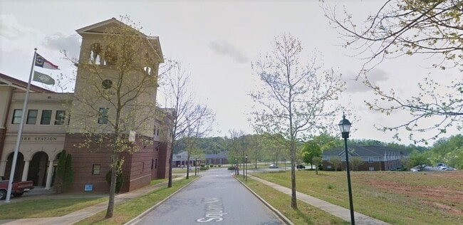
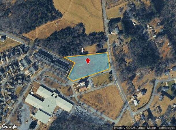
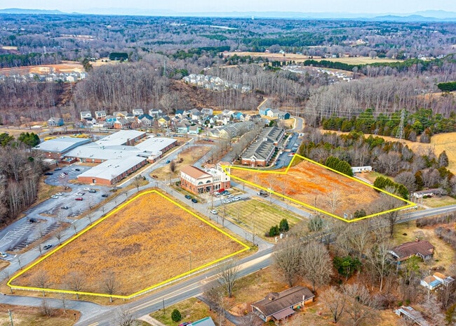
1840 Edgewater Dr Nw
3743127580090000
CLINE VILLAGE
Vacantlandnec
Catawba
X
North Carolina
3710374300J
2.22 AC
2024
Catawba County
2025
Charlotte
010203
Hickory-Lenoir-Morganton, NC
DEMOGRAPHICS near 1840 Edgewater Dr Nw
1 Mile
3 Mile
5 Mile
2024 Total Population
1,208
14,037
40,487
2029 Population
1,246
14,648
42,164
Pop Growth 2024-2029
+ 3.15%
+ 4.35%
+ 4.14%
Average Age
40
41
41
2024 Total Households
455
5,521
15,704
HH Growth 2024-2029
+ 3.08%
+ 4.22%
+ 4.06%
Median Household Inc
$60,949
$61,232
$57,629
Avg Household Size
2.60
2.50
2.50
2024 Avg HH Vehicles
2.00
2.00
2.00
Median Home Value
$165,195
$193,896
$184,630
Median Year Built
1993
1991
1987
Nearby Places
Map Layers
Map Styles
 Street
 Aerial
- Restaurants
- Banks
- Shops
- Fitness
- Groceries
Nearby Properties
Address
Land Use
TOTAL SIZE
Lot Size
Zoning
Address
Land Use
TOTAL SIZE
Lot Size
Zoning
7,684 SF
11.85 AC
R-20-CD
Address
Land Use
TOTAL SIZE
Lot Size
Zoning
217,586 SF
28.33 AC
CC-CD
Address
Land Use
TOTAL SIZE
Lot Size
Zoning
30.63 AC
R-20
Address
Land Use
TOTAL SIZE
Lot Size
Zoning
4,700 SF
34.87 AC
COI
Address
Land Use
TOTAL SIZE
Lot Size
Zoning
23,646 SF
79.60 AC
M-1
Address
Land Use
TOTAL SIZE
Lot Size
Zoning
14,702 SF
363.28 AC
R-20
Address
Land Use
TOTAL SIZE
Lot Size
Zoning
26.72 AC
R-30
Address
Land Use
TOTAL SIZE
Lot Size
Zoning
15.14 AC
NC
Address
Land Use
TOTAL SIZE
Lot Size
Zoning
29,958 SF
2.09 AC
CC
Address
Land Use
TOTAL SIZE
Lot Size
Zoning
21.85 AC
R-20
Address
Land Use
TOTAL SIZE
Lot Size
Zoning
133,559 SF
15.08 AC
B-2-CD
Address
Land Use
TOTAL SIZE
Lot Size
Zoning
13.54 AC
R-20
Address
Land Use
TOTAL SIZE
Lot Size
Zoning
117,101 SF
17.05 AC
M-1
Address
Land Use
TOTAL SIZE
Lot Size
Zoning
15,202 SF
352.85 AC
R-20
Address
Land Use
TOTAL SIZE
Lot Size
Zoning
116,145 SF
9.16 AC
EM-1
Address
Land Use
TOTAL SIZE
Lot Size
Zoning
20,818 SF
23.72 AC
M-1
Address
Land Use
TOTAL SIZE
Lot Size
Zoning
28,655 SF
4.81 AC
R-9A
Address
Land Use
TOTAL SIZE
Lot Size
Zoning
129,960 SF
19.23 AC
M-1
Address
Land Use
TOTAL SIZE
Lot Size
Zoning
29,632 SF
7.41 AC
R-9A
Address
Land Use
TOTAL SIZE
Lot Size
Zoning
36,259 SF
7 AC
P-1
Address
Land Use
TOTAL SIZE
Lot Size
Zoning
221.01 AC
M-1-CD
Address
Land Use
TOTAL SIZE
Lot Size
Zoning
10,990 SF
6.27 AC
B-2
Address
Land Use
TOTAL SIZE
Lot Size
Zoning
83,200 SF
4.99 AC
M-1
Address
Land Use
TOTAL SIZE
Lot Size
Zoning
43,852 SF
2.02 AC
MX-CD
Address
Land Use
TOTAL SIZE
Lot Size
Zoning
8,939 SF
2.42 AC
R-9A-CD
Address
Land Use
TOTAL SIZE
Lot Size
Zoning
82,655 SF
6.72 AC
M-1
Address
Land Use
TOTAL SIZE
Lot Size
Zoning
2,630 SF
2.73 AC
CC
Address
Land Use
TOTAL SIZE
Lot Size
Zoning
12,874 SF
5.58 AC
R-30
Address
Land Use
TOTAL SIZE
Lot Size
Zoning
4,752 SF
2.63 AC
R-9A
Address
Land Use
TOTAL SIZE
Lot Size
Zoning
768 SF
16.09 AC
R-20-CD
The World's #1 Commercial Real Estate Marketplace
Connect with us
© 2026 CoStar Group
The information above has been obtained from sources believed reliable. While we do not doubt its accuracy we have not verified it and make no guarantee, warranty or representation about it. It is your responsibility to independently confirm its accuracy and completeness. Any projections, opinions, assumptions, or estimates used are for example only and do not represent the current or future performance of the property. The value of this transaction to you depends on tax and other factors which should be evaluated by your tax, financial, and legal advisors. You and your advisors should conduct a careful, independent investigation of the property to determine to your satisfaction the suitability of the property for your needs.