Property Record
1840 Gordon Hwy, Augusta, GA 30904


This Property Is For Sale
NEARBY LISTINGS FOR SALE OR LEASE
Property Detail
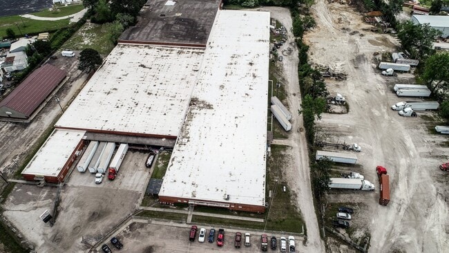
1840 Gordon Hwy
0702039000
GORDON HWY
Commercialacreage
Richmond
X
Georgia
13245C0108G
7.05 AC
2025
South Richmond County
2025
Augusta/Richmond County
010300
Augusta-Richmond County, GA-SC
173,851 SF
DEMOGRAPHICS near 1840 Gordon Hwy
1 Mile
3 Mile
5 Mile
2024 Total Population
6,080
60,502
139,651
2029 Population
5,995
60,382
138,998
Pop Growth 2024-2029
(1.40%)
(0.20%)
(0.47%)
Average Age
38
39
39
2024 Total Households
2,614
25,893
60,257
HH Growth 2024-2029
(1.38%)
(0.09%)
(0.39%)
Median Household Inc
$27,788
$38,343
$45,506
Avg Household Size
2.20
2.20
2.20
2024 Avg HH Vehicles
1.00
1.00
2.00
Median Home Value
$96,108
$129,313
$141,208
Median Year Built
1963
1963
1974
Nearby Places
Map Layers
Map Styles
 Street
 Aerial
- Restaurants
- Banks
- Shops
- Fitness
- Groceries
PUBLIC TRANSPORTATION
AIRPORT
Augusta Regional at Bush Field
DRIVE
WALK
Distance
Augusta Regional at Bush Field
18 min
7.8 mi
Freight Ports
Georgia Ports - Savannah
DRIVE
WALK
Distance
Georgia Ports - Savannah
153 min
118.4 mi
Nearby Properties
Address
Land Use
TOTAL SIZE
Lot Size
Zoning
Address
Land Use
TOTAL SIZE
Lot Size
Zoning
1,100 SF
97.38 AC
R-1A
Address
Land Use
TOTAL SIZE
Lot Size
Zoning
292,232 SF
39.73 AC
B-2
Address
Land Use
TOTAL SIZE
Lot Size
Zoning
202,994 SF
19.25 AC
P-1
Address
Land Use
TOTAL SIZE
Lot Size
Zoning
102,429 SF
7.31 AC
PUD
Address
Land Use
TOTAL SIZE
Lot Size
Zoning
255,834 SF
5.56 AC
B-1
Address
Land Use
TOTAL SIZE
Lot Size
Zoning
102,748 SF
22.60 AC
R-3B
Address
Land Use
TOTAL SIZE
Lot Size
Zoning
1,428 SF
75.91 AC
R-1A
Address
Land Use
TOTAL SIZE
Lot Size
Zoning
36,755 SF
12.09 AC
B-2
Address
Land Use
TOTAL SIZE
Lot Size
Zoning
1,620 SF
21.51 AC
R-3B
Address
Land Use
TOTAL SIZE
Lot Size
Zoning
38,080 SF
19.19 AC
R-3B
Address
Land Use
TOTAL SIZE
Lot Size
Zoning
1,782 SF
26.27 AC
R-3A
Address
Land Use
TOTAL SIZE
Lot Size
Zoning
6,323 SF
25.49 AC
R-3C
Address
Land Use
TOTAL SIZE
Lot Size
Zoning
241,284 SF
20.61 AC
R-1A
Address
Land Use
TOTAL SIZE
Lot Size
Zoning
8,640 SF
13.15 AC
R-3B
Address
Land Use
TOTAL SIZE
Lot Size
Zoning
102,060 SF
45.63 AC
R-3B
Address
Land Use
TOTAL SIZE
Lot Size
Zoning
68,600 SF
20.94 AC
R-3A
Address
Land Use
TOTAL SIZE
Lot Size
Zoning
21,615 SF
207.78 AC
R-1
Address
Land Use
TOTAL SIZE
Lot Size
Zoning
56,631 SF
11.62 AC
R-1A, B-2
Address
Land Use
TOTAL SIZE
Lot Size
Zoning
90,447 SF
1.28 AC
B-1
Address
Land Use
TOTAL SIZE
Lot Size
Zoning
4,507 SF
56.06 AC
HI
Address
Land Use
TOTAL SIZE
Lot Size
Zoning
4,947 SF
71.24 AC
R-3B
Address
Land Use
TOTAL SIZE
Lot Size
Zoning
16,914 SF
29.85 AC
R-1
Address
Land Use
TOTAL SIZE
Lot Size
Zoning
16,120 SF
21.38 AC
R-3A
Address
Land Use
TOTAL SIZE
Lot Size
Zoning
52,896 SF
22.90 AC
B-1
Address
Land Use
TOTAL SIZE
Lot Size
Zoning
158,192 SF
48.91 AC
R-1A
Address
Land Use
TOTAL SIZE
Lot Size
Zoning
27,976 SF
1.25 AC
B-1_R-1C S
Address
Land Use
TOTAL SIZE
Lot Size
Zoning
44,160 SF
12.46 AC
R-3B
Address
Land Use
TOTAL SIZE
Lot Size
Zoning
35,263 SF
19.63 AC
B-1
Address
Land Use
TOTAL SIZE
Lot Size
Zoning
Address
Land Use
TOTAL SIZE
Lot Size
Zoning
30,583 SF
15.28 AC
B-1
The World's #1 Commercial Real Estate Marketplace
Connect with us
© 2025 CoStar Group
The information above has been obtained from sources believed reliable. While we do not doubt its accuracy we have not verified it and make no guarantee, warranty or representation about it. It is your responsibility to independently confirm its accuracy and completeness. Any projections, opinions, assumptions, or estimates used are for example only and do not represent the current or future performance of the property. The value of this transaction to you depends on tax and other factors which should be evaluated by your tax, financial, and legal advisors. You and your advisors should conduct a careful, independent investigation of the property to determine to your satisfaction the suitability of the property for your needs.