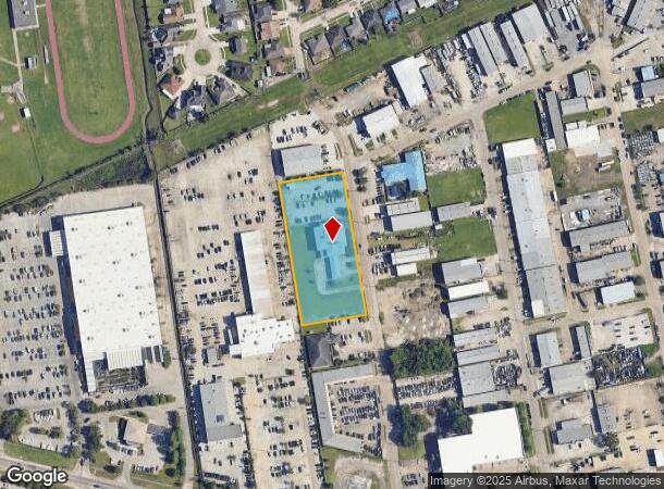
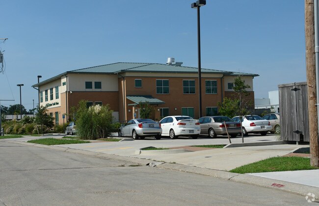
Property Record
1840 Jutland Dr, Harvey, LA 70058

NEARBY LISTINGS FOR SALE OR LEASE
Property Detail
1840 Jutland Dr
New Orleans-Metairie, LA
Lapalco Comm Pk
0410000915
LOT 8A SQ A LAPALCO COMM PK
Realpropertynec
Jefferson
X
Louisiana
22051C0215F
8a
2024
2.07 AC
2024
Outer Jefferson Parish
027818
New Orleans/Metairie/Kenner
DEMOGRAPHICS near 1840 Jutland Dr
1 Mile
3 Mile
5 Mile
2024 Total Population
8,644
90,906
236,290
2029 Population
8,248
87,224
227,651
Pop Growth 2024-2029
(4.58%)
(4.05%)
(3.66%)
Average Age
44
40
40
2024 Total Households
3,293
34,279
95,661
HH Growth 2024-2029
(4.74%)
(4.17%)
(3.71%)
Median Household Inc
$74,999
$51,629
$56,430
Avg Household Size
2.60
2.60
2.30
2024 Avg HH Vehicles
2.00
2.00
2.00
Median Home Value
$220,904
$169,843
$216,673
Median Year Built
1978
1975
1970
Nearby Places
Map Layers
Map Styles
 Street
 Aerial
- Restaurants
- Banks
- Shops
- Fitness
- Groceries
PUBLIC TRANSPORTATION
AIRPORT
Louis Armstrong New Orleans International
DRIVE
WALK
Distance
Louis Armstrong New Orleans International
35 min
20.3 mi
Freight Ports
Port of New Orleans
DRIVE
WALK
Distance
Port of New Orleans
21 min
10.9 mi
Nearby Properties
Address
Land Use
TOTAL SIZE
Lot Size
Zoning
Address
Land Use
TOTAL SIZE
Lot Size
Zoning
Address
Land Use
TOTAL SIZE
Lot Size
Zoning
0.14 AC
Address
Land Use
TOTAL SIZE
Lot Size
Zoning
4.12 AC
Address
Land Use
TOTAL SIZE
Lot Size
Zoning
53.64 AC
Address
Land Use
TOTAL SIZE
Lot Size
Zoning
1.15 AC
Address
Land Use
TOTAL SIZE
Lot Size
Zoning
0.17 AC
Address
Land Use
TOTAL SIZE
Lot Size
Zoning
3.55 AC
Address
Land Use
TOTAL SIZE
Lot Size
Zoning
12.79 AC
Address
Land Use
TOTAL SIZE
Lot Size
Zoning
14.69 AC
Address
Land Use
TOTAL SIZE
Lot Size
Zoning
21.96 AC
MUCD
Address
Land Use
TOTAL SIZE
Lot Size
Zoning
Address
Land Use
TOTAL SIZE
Lot Size
Zoning
0.78 AC
Address
Land Use
TOTAL SIZE
Lot Size
Zoning
2.76 AC
Address
Land Use
TOTAL SIZE
Lot Size
Zoning
20.52 AC
MUCD
Address
Land Use
TOTAL SIZE
Lot Size
Zoning
Address
Land Use
TOTAL SIZE
Lot Size
Zoning
42.23 AC
Address
Land Use
TOTAL SIZE
Lot Size
Zoning
31.14 AC
MUCD
Address
Land Use
TOTAL SIZE
Lot Size
Zoning
0.13 AC
Address
Land Use
TOTAL SIZE
Lot Size
Zoning
9.57 AC
Address
Land Use
TOTAL SIZE
Lot Size
Zoning
0.22 AC
Address
Land Use
TOTAL SIZE
Lot Size
Zoning
0.10 AC
Address
Land Use
TOTAL SIZE
Lot Size
Zoning
0.18 AC
Address
Land Use
TOTAL SIZE
Lot Size
Zoning
0.15 AC
Address
Land Use
TOTAL SIZE
Lot Size
Zoning
0.15 AC
Address
Land Use
TOTAL SIZE
Lot Size
Zoning
10.90 AC
Address
Land Use
TOTAL SIZE
Lot Size
Zoning
0.10 AC
Address
Land Use
TOTAL SIZE
Lot Size
Zoning
0.17 AC
Address
Land Use
TOTAL SIZE
Lot Size
Zoning
10.63 AC
MUCD
Address
Land Use
TOTAL SIZE
Lot Size
Zoning
2.92 AC
Address
Land Use
TOTAL SIZE
Lot Size
Zoning
3.25 AC
The World's #1 Commercial Real Estate Marketplace
Connect with us
© 2025 CoStar Group
The information above has been obtained from sources believed reliable. While we do not doubt its accuracy we have not verified it and make no guarantee, warranty or representation about it. It is your responsibility to independently confirm its accuracy and completeness. Any projections, opinions, assumptions, or estimates used are for example only and do not represent the current or future performance of the property. The value of this transaction to you depends on tax and other factors which should be evaluated by your tax, financial, and legal advisors. You and your advisors should conduct a careful, independent investigation of the property to determine to your satisfaction the suitability of the property for your needs.