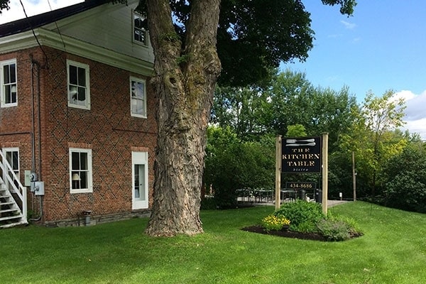
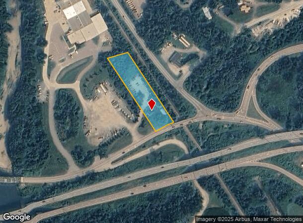
Property Record
1840 W Main St, Richmond, VT 05477

NEARBY LISTINGS FOR SALE OR LEASE
-
-
View all Richmond listings for sale on LoopNet.com
Property Detail
1840 W Main St
(163) WM1840
COMM
Commercialnec
Chittenden
X
Vermont
50007C0292E
1.17 AC
2022
Vermont North Area
2024
Other Market Areas
003000
Burlington-South Burlington, VT
4,490 SF
DEMOGRAPHICS near 1840 W Main St
1 Mile
3 Mile
5 Mile
2024 Total Population
560
4,231
13,291
2029 Population
559
4,243
13,418
Pop Growth 2024-2029
(0.18%)
+ 0.28%
+ 0.96%
Average Age
41
43
43
2024 Total Households
226
1,709
5,369
HH Growth 2024-2029
0.00%
+ 0.41%
+ 1.12%
Median Household Inc
$103,385
$108,349
$112,616
Avg Household Size
2.50
2.50
2.50
2024 Avg HH Vehicles
2.00
2.00
2.00
Median Home Value
$417,442
$440,757
$431,733
Median Year Built
1978
1982
1985
Nearby Places
Map Layers
Map Styles
 Street
 Aerial
- Restaurants
- Banks
- Shops
- Fitness
- Groceries
PUBLIC TRANSPORTATION
COMMUTER RAIL
DRIVE
WALK
Distance
14 min
8.3 mi
AIRPORT
Patrick Leahy Burlington International
DRIVE
WALK
Distance
Patrick Leahy Burlington International
23 min
11.0 mi
Plattsburgh International
DRIVE
WALK
Distance
Plattsburgh International
78 min
44.3 mi
SALE & LEASE HISTORY
LISTING DATE
SALE/LEASE

Dec 23, 2021
For Sale
Nearby Properties
Address
Land Use
TOTAL SIZE
Lot Size
Zoning
Address
Land Use
TOTAL SIZE
Lot Size
Zoning
15.65 AC
Address
Land Use
TOTAL SIZE
Lot Size
Zoning
Address
Land Use
TOTAL SIZE
Lot Size
Zoning
7.69 AC
Address
Land Use
TOTAL SIZE
Lot Size
Zoning
Address
Land Use
TOTAL SIZE
Lot Size
Zoning
114.67 AC
Address
Land Use
TOTAL SIZE
Lot Size
Zoning
12,951 SF
5.84 AC
Address
Land Use
TOTAL SIZE
Lot Size
Zoning
16,335 SF
2.50 AC
Address
Land Use
TOTAL SIZE
Lot Size
Zoning
11.94 AC
Address
Land Use
TOTAL SIZE
Lot Size
Zoning
Address
Land Use
TOTAL SIZE
Lot Size
Zoning
275.24 AC
Address
Land Use
TOTAL SIZE
Lot Size
Zoning
9,588 SF
1.51 AC
Address
Land Use
TOTAL SIZE
Lot Size
Zoning
Address
Land Use
TOTAL SIZE
Lot Size
Zoning
1.96 AC
Address
Land Use
TOTAL SIZE
Lot Size
Zoning
11,085 SF
1.13 AC
Address
Land Use
TOTAL SIZE
Lot Size
Zoning
20,373 SF
3.73 AC
Address
Land Use
TOTAL SIZE
Lot Size
Zoning
171.92 AC
Address
Land Use
TOTAL SIZE
Lot Size
Zoning
1,550 SF
567.30 AC
Address
Land Use
TOTAL SIZE
Lot Size
Zoning
5,468 SF
0.50 AC
Address
Land Use
TOTAL SIZE
Lot Size
Zoning
4.42 AC
Address
Land Use
TOTAL SIZE
Lot Size
Zoning
25.51 AC
Address
Land Use
TOTAL SIZE
Lot Size
Zoning
1.26 AC
Address
Land Use
TOTAL SIZE
Lot Size
Zoning
10,436 SF
1.08 AC
Address
Land Use
TOTAL SIZE
Lot Size
Zoning
3,264 SF
343.84 AC
Address
Land Use
TOTAL SIZE
Lot Size
Zoning
4,196 SF
0.40 AC
Address
Land Use
TOTAL SIZE
Lot Size
Zoning
4,190 SF
0.50 AC
Address
Land Use
TOTAL SIZE
Lot Size
Zoning
3,413 SF
130.78 AC
Address
Land Use
TOTAL SIZE
Lot Size
Zoning
3,174 SF
Address
Land Use
TOTAL SIZE
Lot Size
Zoning
1.64 AC
Address
Land Use
TOTAL SIZE
Lot Size
Zoning
2.58 AC
Address
Land Use
TOTAL SIZE
Lot Size
Zoning
6.65 AC
The World's #1 Commercial Real Estate Marketplace
Connect with us
© 2025 CoStar Group
The information above has been obtained from sources believed reliable. While we do not doubt its accuracy we have not verified it and make no guarantee, warranty or representation about it. It is your responsibility to independently confirm its accuracy and completeness. Any projections, opinions, assumptions, or estimates used are for example only and do not represent the current or future performance of the property. The value of this transaction to you depends on tax and other factors which should be evaluated by your tax, financial, and legal advisors. You and your advisors should conduct a careful, independent investigation of the property to determine to your satisfaction the suitability of the property for your needs.