Property Record
18401 Highway 24, Woodland Park, CO 80863
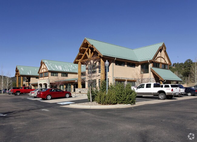

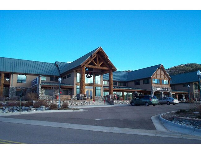
Property Detail
18401 Highway 24
R0044170
L1 MORNING SUN DRIVE SUBDIVISION
Officebuilding
Teller
C1
Colorado
B and X Area of moderate flood hazard, usually the area between the limits of the 100-year and 500-year floods.
1
2025
1.66 AC
2025
Teller County
010107
Colorado Springs
18,228 SF
Colorado Springs, CO
NEARBY LISTINGS FOR SALE OR LEASE
DEMOGRAPHICS near 18401 Highway 24
1 mile
3 mile
5 mile
2025 Total Population
1,332
9,534
13,169
2030 Population
1,320
9,446
13,081
Pop Growth 2025-2030
(0.90%)
(0.92%)
(0.67%)
Average Age
47
46
46
2025 Total Households
596
4,023
5,548
HH Growth 2025-2030
(0.84%)
(0.89%)
(0.65%)
Median Household Inc
$90,340
$97,748
$100,307
Avg Household Size
2.20
2.30
2.30
2025 Avg HH Vehicles
2.00
2.00
2.00
Median Home Value
$596,154
$562,325
$574,543
Median Year Built
1988
1986
1984
Nearby Places
Map Layers
Map Styles
 Street
 Aerial
Layers
 Traffic
 Biking
Places
Listings with unknown addresses are not visible on the map
- Restaurants
- Banks
- Shops
- Fitness
- Groceries
PUBLIC TRANSPORTATION
AIRPORT
City of Colorado Springs Municipal
Drive
Walk
Distance
City of Colorado Springs Municipal
45 min
27.3 mi
SALE & LEASE HISTORY
LISTING DATE
SALE/LEASE

Sep 28, 2016
For Lease
Nov 10, 2021
For Lease
Nearby Properties
Address
Land Use
TOTAL SIZE
Lot Size
Zoning
Address
Land Use
TOTAL SIZE
Lot Size
Zoning
53,716 SF
70.99 AC
R-T
Address
Land Use
TOTAL SIZE
Lot Size
Zoning
41,542 SF
145.43 AC
Address
Land Use
TOTAL SIZE
Lot Size
Zoning
161,632 SF
19.24 AC
A1
Address
Land Use
TOTAL SIZE
Lot Size
Zoning
13,179 SF
2.01 AC
Address
Land Use
TOTAL SIZE
Lot Size
Zoning
31,654 SF
Address
Land Use
TOTAL SIZE
Lot Size
Zoning
20,398 SF
Address
Land Use
TOTAL SIZE
Lot Size
Zoning
54,600 SF
6.70 AC
WP
Address
Land Use
TOTAL SIZE
Lot Size
Zoning
8,645 SF
3.09 AC
WP
Address
Land Use
TOTAL SIZE
Lot Size
Zoning
13,221 SF
1.53 AC
Address
Land Use
TOTAL SIZE
Lot Size
Zoning
18,325 SF
2.10 AC
WP
Address
Land Use
TOTAL SIZE
Lot Size
Zoning
8,520 SF
1.36 AC
WPCC
Address
Land Use
TOTAL SIZE
Lot Size
Zoning
2,855 SF
1.56 AC
Address
Land Use
TOTAL SIZE
Lot Size
Zoning
33,680 SF
1.30 AC
WP
Address
Land Use
TOTAL SIZE
Lot Size
Zoning
32,146 SF
2.06 AC
Address
Land Use
TOTAL SIZE
Lot Size
Zoning
12,054 SF
0.60 AC
Address
Land Use
TOTAL SIZE
Lot Size
Zoning
5,041 SF
2.49 AC
WP
Address
Land Use
TOTAL SIZE
Lot Size
Zoning
12,839 SF
5.94 AC
WP
Address
Land Use
TOTAL SIZE
Lot Size
Zoning
21,970 SF
5.24 AC
Address
Land Use
TOTAL SIZE
Lot Size
Zoning
23,056 SF
2.46 AC
Address
Land Use
TOTAL SIZE
Lot Size
Zoning
880 SF
29.27 AC
R-T
Address
Land Use
TOTAL SIZE
Lot Size
Zoning
1,192 SF
1.60 AC
C1
Address
Land Use
TOTAL SIZE
Lot Size
Zoning
8,798 SF
4.88 AC
WPPUD
Address
Land Use
TOTAL SIZE
Lot Size
Zoning
2,560 SF
3.80 AC
WP
Address
Land Use
TOTAL SIZE
Lot Size
Zoning
10,581 SF
1.14 AC
WP
Address
Land Use
TOTAL SIZE
Lot Size
Zoning
12,300 SF
0.58 AC
WP
Address
Land Use
TOTAL SIZE
Lot Size
Zoning
5,227 SF
0.92 AC
A1
Address
Land Use
TOTAL SIZE
Lot Size
Zoning
1,480 SF
40 AC
A-5
Address
Land Use
TOTAL SIZE
Lot Size
Zoning
9,982 SF
1.12 AC
WP
Address
Land Use
TOTAL SIZE
Lot Size
Zoning
14,171 SF
1.37 AC
WP
Address
Land Use
TOTAL SIZE
Lot Size
Zoning
11,700 SF
0.55 AC
WP
The World's #1 Commercial Real Estate Marketplace
Connect with us
© 2026 CoStar Group
The information above has been obtained from sources believed reliable. While we do not doubt its accuracy we have not verified it and make no guarantee, warranty or representation about it. It is your responsibility to independently confirm its accuracy and completeness. Any projections, opinions, assumptions, or estimates used are for example only and do not represent the current or future performance of the property. The value of this transaction to you depends on tax and other factors which should be evaluated by your tax, financial, and legal advisors. You and your advisors should conduct a careful, independent investigation of the property to determine to your satisfaction the suitability of the property for your needs.