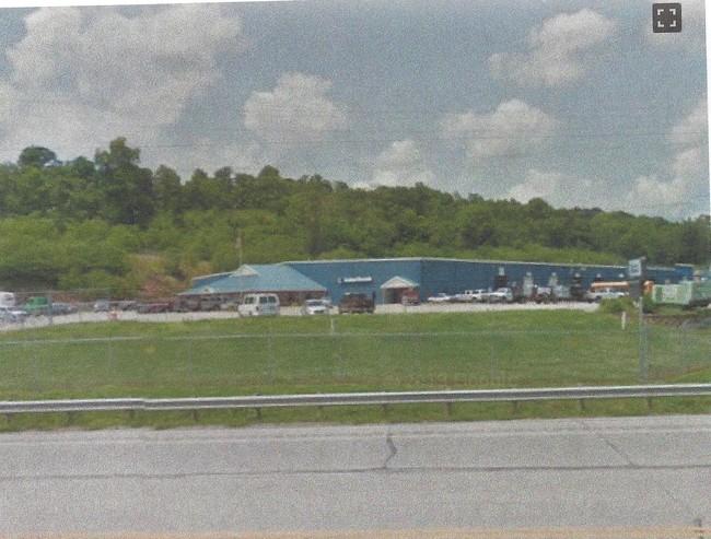
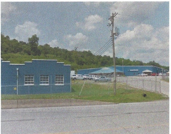
Property Record
18417 State Route 7, Marietta, OH 45750
NEARBY LISTINGS FOR SALE OR LEASE
Property Detail
18417 State Route 7
3400-61468-000
R9 T2 S3 160 AC LOT 291 11.94 AC
Officebuilding
Washington
X
Ohio
39167C0263F
291
2024
11.94 AC
2024
Ohio South Area
020300
Other Market Areas
3,102 SF
Marietta, OH
DEMOGRAPHICS near 18417 State Route 7
1 Mile
3 Mile
5 Mile
2024 Total Population
423
8,880
33,518
2029 Population
435
8,855
33,103
Pop Growth 2024-2029
+ 2.84%
(0.28%)
(1.24%)
Average Age
45
44
42
2024 Total Households
181
3,866
14,228
HH Growth 2024-2029
+ 2.76%
(0.34%)
(1.24%)
Median Household Inc
$65,892
$59,546
$59,134
Avg Household Size
2.30
2.20
2.30
2024 Avg HH Vehicles
2.00
2.00
2.00
Median Home Value
$157,272
$161,860
$167,367
Median Year Built
1986
1973
1969
Nearby Places
Map Layers
Map Styles
 Street
 Aerial
- Restaurants
- Banks
- Shops
- Fitness
- Groceries
SALE & LEASE HISTORY
LISTING DATE
SALE/LEASE

Sep 27, 2017
For Sale
Sep 27, 2017
For Sale
Nearby Properties
Address
Land Use
TOTAL SIZE
Lot Size
Zoning
Address
Land Use
TOTAL SIZE
Lot Size
Zoning
4.50 AC
Address
Land Use
TOTAL SIZE
Lot Size
Zoning
Address
Land Use
TOTAL SIZE
Lot Size
Zoning
14.36 AC
Address
Land Use
TOTAL SIZE
Lot Size
Zoning
31.05 AC
Address
Land Use
TOTAL SIZE
Lot Size
Zoning
3.34 AC
Address
Land Use
TOTAL SIZE
Lot Size
Zoning
279.08 AC
Address
Land Use
TOTAL SIZE
Lot Size
Zoning
9,975 SF
14.36 AC
Address
Land Use
TOTAL SIZE
Lot Size
Zoning
9,975 SF
1 AC
Address
Land Use
TOTAL SIZE
Lot Size
Zoning
Address
Land Use
TOTAL SIZE
Lot Size
Zoning
Address
Land Use
TOTAL SIZE
Lot Size
Zoning
1,449 SF
1.19 AC
Address
Land Use
TOTAL SIZE
Lot Size
Zoning
0.27 AC
Address
Land Use
TOTAL SIZE
Lot Size
Zoning
1.65 AC
Address
Land Use
TOTAL SIZE
Lot Size
Zoning
14.18 AC
Address
Land Use
TOTAL SIZE
Lot Size
Zoning
6.10 AC
Address
Land Use
TOTAL SIZE
Lot Size
Zoning
39,440 SF
5.46 AC
Address
Land Use
TOTAL SIZE
Lot Size
Zoning
16.61 AC
Address
Land Use
TOTAL SIZE
Lot Size
Zoning
2,800 SF
9.18 AC
Address
Land Use
TOTAL SIZE
Lot Size
Zoning
Address
Land Use
TOTAL SIZE
Lot Size
Zoning
0.77 AC
Address
Land Use
TOTAL SIZE
Lot Size
Zoning
Address
Land Use
TOTAL SIZE
Lot Size
Zoning
2,232 SF
2.56 AC
Address
Land Use
TOTAL SIZE
Lot Size
Zoning
Address
Land Use
TOTAL SIZE
Lot Size
Zoning
75,000 SF
1.07 AC
Address
Land Use
TOTAL SIZE
Lot Size
Zoning
9,932 SF
0.43 AC
Address
Land Use
TOTAL SIZE
Lot Size
Zoning
16.50 AC
Address
Land Use
TOTAL SIZE
Lot Size
Zoning
80.02 AC
Address
Land Use
TOTAL SIZE
Lot Size
Zoning
Address
Land Use
TOTAL SIZE
Lot Size
Zoning
21,202 SF
0.18 AC
The World's #1 Commercial Real Estate Marketplace
Connect with us
© 2026 CoStar Group
The information above has been obtained from sources believed reliable. While we do not doubt its accuracy we have not verified it and make no guarantee, warranty or representation about it. It is your responsibility to independently confirm its accuracy and completeness. Any projections, opinions, assumptions, or estimates used are for example only and do not represent the current or future performance of the property. The value of this transaction to you depends on tax and other factors which should be evaluated by your tax, financial, and legal advisors. You and your advisors should conduct a careful, independent investigation of the property to determine to your satisfaction the suitability of the property for your needs.