Property Record
18433 Fm 529 Rd, Cypress, TX 77433
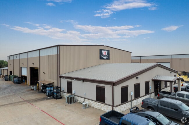

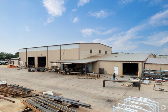
Property Detail
18433 Fm 529 Rd
0440400000066
TR 4A-5 ABST 616 J C OGBURN
Outdoorrecreationbeachmountaindesert
HARRIS
B and X Area of moderate flood hazard, usually the area between the limits of the 100-year and 500-year floods.
Texas
2024
3.72 AC
2025
Northwest Outliers
542108
Houston
27,500 SF
Houston-Pasadena-The Woodlands, TX
NEARBY LISTINGS FOR SALE OR LEASE
DEMOGRAPHICS near 18433 Fm 529 Rd
1 mile
3 mile
5 mile
2025 Total Population
20,786
171,619
348,704
2030 Population
21,817
181,940
370,880
Pop Growth 2025-2030
+ 4.96%
+ 6.01%
+ 6.36%
Average Age
35
36
36
2025 Total Households
6,106
52,716
108,853
HH Growth 2025-2030
+ 5.14%
+ 6.17%
+ 6.51%
Median Household Inc
$84,165
$93,385
$92,886
Avg Household Size
3.30
3.20
3.10
2025 Avg HH Vehicles
2.00
2.00
2.00
Median Home Value
$246,577
$282,307
$291,021
Median Year Built
2000
2003
2002
Nearby Places
Map Layers
Map Styles
 Street
 Aerial
Transit
 Traffic
 Biking
Places
Listings with unknown addresses are not visible on the map
- Restaurants
- Banks
- Shops
- Fitness
- Groceries
PUBLIC TRANSPORTATION
AIRPORT
George Bush Intcntl/Houston
Drive
Walk
Distance
George Bush Intcntl/Houston
38 min
26.7 mi
William P Hobby
Drive
Walk
Distance
William P Hobby
57 min
37.3 mi
Freight Ports
Port of Houston
Drive
Walk
Distance
Port of Houston
48 min
33.0 mi
Nearby Properties
Address
Land Use
TOTAL SIZE
Lot Size
Zoning
Address
Land Use
TOTAL SIZE
Lot Size
Zoning
386,642 SF
14.45 AC
Address
Land Use
TOTAL SIZE
Lot Size
Zoning
355,721 SF
13 AC
Address
Land Use
TOTAL SIZE
Lot Size
Zoning
379,588 SF
12.06 AC
Address
Land Use
TOTAL SIZE
Lot Size
Zoning
323,609 SF
12.71 AC
Address
Land Use
TOTAL SIZE
Lot Size
Zoning
331,263 SF
11.36 AC
Address
Land Use
TOTAL SIZE
Lot Size
Zoning
320,084 SF
8.01 AC
Address
Land Use
TOTAL SIZE
Lot Size
Zoning
418,572 SF
24.76 AC
Address
Land Use
TOTAL SIZE
Lot Size
Zoning
388,223 SF
14.99 AC
Address
Land Use
TOTAL SIZE
Lot Size
Zoning
262,174 SF
11.64 AC
Address
Land Use
TOTAL SIZE
Lot Size
Zoning
290,927 SF
14.53 AC
Address
Land Use
TOTAL SIZE
Lot Size
Zoning
292,466 SF
12.18 AC
Address
Land Use
TOTAL SIZE
Lot Size
Zoning
97,084 SF
2.09 AC
Address
Land Use
TOTAL SIZE
Lot Size
Zoning
191,673 SF
7.29 AC
Address
Land Use
TOTAL SIZE
Lot Size
Zoning
186,161 SF
8.65 AC
Address
Land Use
TOTAL SIZE
Lot Size
Zoning
147,900 SF
5.76 AC
Address
Land Use
TOTAL SIZE
Lot Size
Zoning
150,570 SF
18.16 AC
Address
Land Use
TOTAL SIZE
Lot Size
Zoning
116,997 SF
10.82 AC
Address
Land Use
TOTAL SIZE
Lot Size
Zoning
215,153 SF
16.34 AC
Address
Land Use
TOTAL SIZE
Lot Size
Zoning
116,160 SF
13.43 AC
Address
Land Use
TOTAL SIZE
Lot Size
Zoning
187,007 SF
9.76 AC
Address
Land Use
TOTAL SIZE
Lot Size
Zoning
125,907 SF
10.54 AC
Address
Land Use
TOTAL SIZE
Lot Size
Zoning
262,048 SF
7 AC
Address
Land Use
TOTAL SIZE
Lot Size
Zoning
131,152 SF
7.14 AC
Address
Land Use
TOTAL SIZE
Lot Size
Zoning
117,860 SF
12.44 AC
Address
Land Use
TOTAL SIZE
Lot Size
Zoning
252,100 SF
9.18 AC
Address
Land Use
TOTAL SIZE
Lot Size
Zoning
204,129 SF
Address
Land Use
TOTAL SIZE
Lot Size
Zoning
193,160 SF
8.99 AC
Address
Land Use
TOTAL SIZE
Lot Size
Zoning
226,029 SF
22.03 AC
Address
Land Use
TOTAL SIZE
Lot Size
Zoning
228,152 SF
22.61 AC
Address
Land Use
TOTAL SIZE
Lot Size
Zoning
136,330 SF
13.08 AC
The World's #1 Commercial Real Estate Marketplace
Connect with us
© 2026 CoStar Group
The information above has been obtained from sources believed reliable. While we do not doubt its accuracy we have not verified it and make no guarantee, warranty or representation about it. It is your responsibility to independently confirm its accuracy and completeness. Any projections, opinions, assumptions, or estimates used are for example only and do not represent the current or future performance of the property. The value of this transaction to you depends on tax and other factors which should be evaluated by your tax, financial, and legal advisors. You and your advisors should conduct a careful, independent investigation of the property to determine to your satisfaction the suitability of the property for your needs.