Property Record
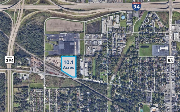
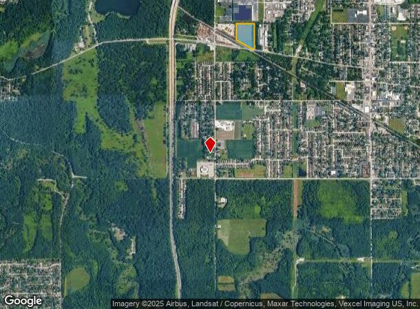
18434 Stony Island Ave, Lansing, IL 60438
This Property Is For Sale
NEARBY LISTINGS FOR SALE OR LEASE
Property Detail
18434 Stony Island Ave
29-36-100-006-0000
Mortons Subdivision
Agriculturalland
Cook
X
Illinois
17031C0754J
10.63 AC
2023
Near South Cook
2024
Chicago
828202
Chicago-Naperville-Elgin, IL-IN-WI
DEMOGRAPHICS near 18434 Stony Island Ave
1 Mile
3 Mile
5 Mile
2024 Total Population
6,917
74,467
235,364
2029 Population
6,745
72,494
231,196
Pop Growth 2024-2029
(2.49%)
(2.65%)
(1.77%)
Average Age
42
42
40
2024 Total Households
2,614
28,574
87,873
HH Growth 2024-2029
(2.75%)
(2.97%)
(2.06%)
Median Household Inc
$67,634
$64,551
$59,247
Avg Household Size
2.50
2.50
2.60
2024 Avg HH Vehicles
2.00
2.00
2.00
Median Home Value
$185,922
$156,390
$151,182
Median Year Built
1973
1967
1963
Nearby Places
- Restaurants
- Banks
- Shops
- Fitness
- Groceries
PUBLIC TRANSPORTATION
COMMUTER RAIL
Dyer Amtrak (Cardinal - Amtrak)
DRIVE
WALK
Distance
Dyer Amtrak (Cardinal - Amtrak)
15 min
7.6 mi
Hazel Crest Station (Metra Electric Line - Northeast Illinois Regional Commuter Railroad (Metra))
DRIVE
WALK
Distance
Hazel Crest Station (Metra Electric Line - Northeast Illinois Regional Commuter Railroad (Metra))
15 min
8.0 mi
AIRPORT
Chicago Midway International
DRIVE
WALK
Distance
Chicago Midway International
39 min
25.3 mi
Freight Ports
Port Milwaukee
DRIVE
WALK
Distance
Port Milwaukee
143 min
111.8 mi
Nearby Properties
Address
Land Use
TOTAL SIZE
Lot Size
Zoning
Address
Land Use
TOTAL SIZE
Lot Size
Zoning
8.27 AC
Address
Land Use
TOTAL SIZE
Lot Size
Zoning
5.01 AC
Address
Land Use
TOTAL SIZE
Lot Size
Zoning
56,458 SF
2.17 AC
Address
Land Use
TOTAL SIZE
Lot Size
Zoning
231,296 SF
10.91 AC
Address
Land Use
TOTAL SIZE
Lot Size
Zoning
7.31 AC
Address
Land Use
TOTAL SIZE
Lot Size
Zoning
454,999 SF
27.43 AC
Address
Land Use
TOTAL SIZE
Lot Size
Zoning
Address
Land Use
TOTAL SIZE
Lot Size
Zoning
44,274 SF
3 AC
Address
Land Use
TOTAL SIZE
Lot Size
Zoning
450,777 SF
25.25 AC
Address
Land Use
TOTAL SIZE
Lot Size
Zoning
398,668 SF
13.92 AC
Address
Land Use
TOTAL SIZE
Lot Size
Zoning
28,228 SF
4.63 AC
Address
Land Use
TOTAL SIZE
Lot Size
Zoning
69,894 SF
7.60 AC
Address
Land Use
TOTAL SIZE
Lot Size
Zoning
Address
Land Use
TOTAL SIZE
Lot Size
Zoning
125,535 SF
9.44 AC
Address
Land Use
TOTAL SIZE
Lot Size
Zoning
89,853 SF
2.68 AC
Address
Land Use
TOTAL SIZE
Lot Size
Zoning
159,145 SF
15.36 AC
Address
Land Use
TOTAL SIZE
Lot Size
Zoning
142,376 SF
24 AC
Address
Land Use
TOTAL SIZE
Lot Size
Zoning
86,780 SF
6.03 AC
Address
Land Use
TOTAL SIZE
Lot Size
Zoning
115,250 SF
10.75 AC
Address
Land Use
TOTAL SIZE
Lot Size
Zoning
100,000 SF
18.10 AC
Address
Land Use
TOTAL SIZE
Lot Size
Zoning
Address
Land Use
TOTAL SIZE
Lot Size
Zoning
3,500 SF
41.36 AC
Address
Land Use
TOTAL SIZE
Lot Size
Zoning
13,524 SF
0.75 AC
R33
Address
Land Use
TOTAL SIZE
Lot Size
Zoning
179,402 SF
10.40 AC
Address
Land Use
TOTAL SIZE
Lot Size
Zoning
136,486 SF
8.73 AC
Address
Land Use
TOTAL SIZE
Lot Size
Zoning
48,134 SF
5.33 AC
Address
Land Use
TOTAL SIZE
Lot Size
Zoning
615,006 SF
61.84 AC
Address
Land Use
TOTAL SIZE
Lot Size
Zoning
79,660 SF
2.57 AC
Address
Land Use
TOTAL SIZE
Lot Size
Zoning
165,530 SF
1.82 AC
Address
Land Use
TOTAL SIZE
Lot Size
Zoning
55,359 SF
2.40 AC
The World's #1 Commercial Real Estate Marketplace
Connect with us
© 2025 CoStar Group
The information above has been obtained from sources believed reliable. While we do not doubt its accuracy we have not verified it and make no guarantee, warranty or representation about it. It is your responsibility to independently confirm its accuracy and completeness. Any projections, opinions, assumptions, or estimates used are for example only and do not represent the current or future performance of the property. The value of this transaction to you depends on tax and other factors which should be evaluated by your tax, financial, and legal advisors. You and your advisors should conduct a careful, independent investigation of the property to determine to your satisfaction the suitability of the property for your needs.