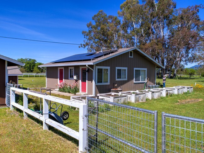
Property Record
1845 E State Highway 20, Upper Lake, CA 95485

Property Detail
1845 E State Highway 20
Multifamilydwelling
Lake
A
California
AE The base floodplain where base flood elevations are provided. AE Zones are now used on new format FIRMs instead of A1-A30 Zones.
16.28 AC
2025
California North Rural Area
2025
Other Market Areas
000100
Clearlake, CA
1,344 SF
201-010-010-000
NEARBY LISTINGS FOR SALE OR LEASE
-
-
View all Upper Lake listings for sale on LoopNet.com
DEMOGRAPHICS near 1845 E State Highway 20
1 mile
3 mile
5 mile
2025 Total Population
226
5,229
8,282
2030 Population
228
5,101
8,213
Pop Growth 2025-2030
+ 0.88%
(2.45%)
(0.83%)
Average Age
42
43
44
2025 Total Households
89
2,156
3,388
HH Growth 2025-2030
+ 1.12%
(2.78%)
(1.09%)
Median Household Inc
$59,999
$61,015
$64,750
Avg Household Size
2.40
2.40
2.40
2025 Avg HH Vehicles
2.00
2.00
2.00
Median Home Value
$450,000
$334,453
$397,435
Median Year Built
1981
1981
1982
Nearby Places
Map Layers
Map Styles
 Street
 Aerial
Layers
 Traffic
 Biking
Places
Listings with unknown addresses are not visible on the map
- Restaurants
- Banks
- Shops
- Fitness
- Groceries
SALE & LEASE HISTORY
LISTING DATE
SALE/LEASE

Jun 27, 2019
For Sale
Nearby Properties
Address
Land Use
TOTAL SIZE
Lot Size
Zoning
Address
Land Use
TOTAL SIZE
Lot Size
Zoning
37,940 SF
11.87 AC
C2
Address
Land Use
TOTAL SIZE
Lot Size
Zoning
10,042 SF
9.98 AC
CR
Address
Land Use
TOTAL SIZE
Lot Size
Zoning
5,768 SF
3.87 AC
CH
Address
Land Use
TOTAL SIZE
Lot Size
Zoning
25,470 SF
4.39 AC
C2
Address
Land Use
TOTAL SIZE
Lot Size
Zoning
15,668 SF
2.95 AC
C2
Address
Land Use
TOTAL SIZE
Lot Size
Zoning
20,210 SF
0.52 AC
C2
Address
Land Use
TOTAL SIZE
Lot Size
Zoning
9,230 SF
1.11 AC
Address
Land Use
TOTAL SIZE
Lot Size
Zoning
4.66 AC
C3
Address
Land Use
TOTAL SIZE
Lot Size
Zoning
3,220 SF
0.69 AC
C2
Address
Land Use
TOTAL SIZE
Lot Size
Zoning
11,088 SF
1.42 AC
CH
Address
Land Use
TOTAL SIZE
Lot Size
Zoning
1.12 AC
C2
Address
Land Use
TOTAL SIZE
Lot Size
Zoning
2,509 SF
1.43 AC
CR
Address
Land Use
TOTAL SIZE
Lot Size
Zoning
1,608 SF
37.06 AC
PDR
Address
Land Use
TOTAL SIZE
Lot Size
Zoning
594 SF
38.89 AC
PDC
Address
Land Use
TOTAL SIZE
Lot Size
Zoning
1,200 SF
40.50 AC
A
Address
Land Use
TOTAL SIZE
Lot Size
Zoning
812 SF
0.32 AC
C2
Address
Land Use
TOTAL SIZE
Lot Size
Zoning
2,166 SF
0.42 AC
R1
Address
Land Use
TOTAL SIZE
Lot Size
Zoning
5,040 SF
1.62 AC
O
Address
Land Use
TOTAL SIZE
Lot Size
Zoning
1,684 SF
4.72 AC
CR
Address
Land Use
TOTAL SIZE
Lot Size
Zoning
Address
Land Use
TOTAL SIZE
Lot Size
Zoning
35.06 AC
A
Address
Land Use
TOTAL SIZE
Lot Size
Zoning
4.89 AC
M2
Address
Land Use
TOTAL SIZE
Lot Size
Zoning
104.20 AC
R1
Address
Land Use
TOTAL SIZE
Lot Size
Zoning
1.64 AC
Address
Land Use
TOTAL SIZE
Lot Size
Zoning
158.07 AC
RL
Address
Land Use
TOTAL SIZE
Lot Size
Zoning
2,350 SF
1.16 AC
R3
Address
Land Use
TOTAL SIZE
Lot Size
Zoning
6,000 SF
0.85 AC
CR
Address
Land Use
TOTAL SIZE
Lot Size
Zoning
4,088 SF
2.63 AC
CH
Address
Land Use
TOTAL SIZE
Lot Size
Zoning
3.10 AC
R3
The World's #1 Commercial Real Estate Marketplace
Connect with us
© 2026 CoStar Group
The information above has been obtained from sources believed reliable. While we do not doubt its accuracy we have not verified it and make no guarantee, warranty or representation about it. It is your responsibility to independently confirm its accuracy and completeness. Any projections, opinions, assumptions, or estimates used are for example only and do not represent the current or future performance of the property. The value of this transaction to you depends on tax and other factors which should be evaluated by your tax, financial, and legal advisors. You and your advisors should conduct a careful, independent investigation of the property to determine to your satisfaction the suitability of the property for your needs.