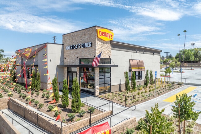
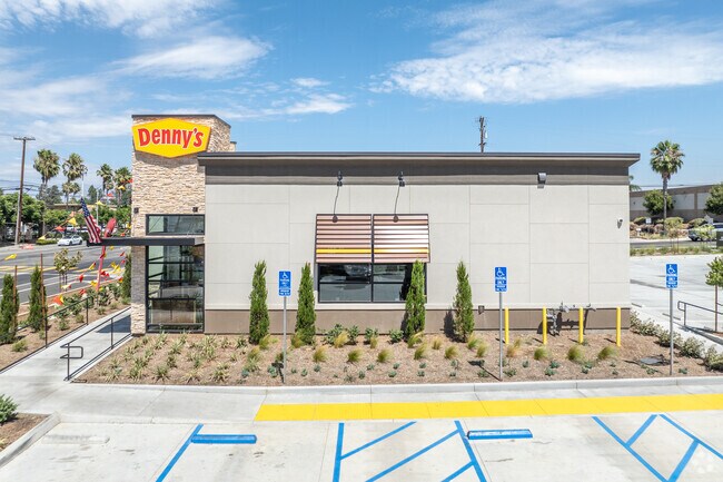
Property Record
18451 Van Buren Blvd, Riverside, CA 92508
NEARBY LISTINGS FOR SALE OR LEASE
Property Detail
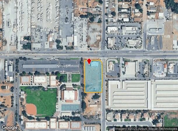
18451 Van Buren Blvd
266-020-077
Parcel Map 8799
Storebuilding
ACRES 1.59000000 ACREAGEQUALCODE ML PARCEL 1-P A MAPPLATB 039 MAPPLATP 088 SUBDIVISIONNAME PM 8799
D
Riverside
06065C0740G
California
2024
1.59 AC
2025
Moreno Valley/Perris
042005
Inland Empire (California)
4,183 SF
Riverside-San Bernardino-Ontario, CA
DEMOGRAPHICS near 18451 Van Buren Blvd
1 Mile
3 Mile
5 Mile
2024 Total Population
8,000
51,519
118,525
2029 Population
8,366
54,037
124,477
Pop Growth 2024-2029
+ 4.58%
+ 4.89%
+ 5.02%
Average Age
37
38
38
2024 Total Households
2,137
14,962
35,818
HH Growth 2024-2029
+ 3.93%
+ 4.49%
+ 4.65%
Median Household Inc
$129,566
$126,061
$103,911
Avg Household Size
3.50
3.30
3.20
2024 Avg HH Vehicles
3.00
3.00
2.00
Median Home Value
$698,434
$685,724
$643,018
Median Year Built
1995
1993
1986
Nearby Places
Map Layers
Map Styles
 Street
 Aerial
- Restaurants
- Banks
- Shops
- Fitness
- Groceries
PUBLIC TRANSPORTATION
COMMUTER RAIL
Moreno Valley/March Field (Metrolink 91-Perris Valley Line - Metrolink Trains)
DRIVE
WALK
Distance
Moreno Valley/March Field (Metrolink 91-Perris Valley Line - Metrolink Trains)
9 min
5.5 mi
Riverside-Downtown (91 Line - Southern California Regional Rail Authority (Metrolink), Inland Empire-Orange County Line - Southern California Regional Rail Authority (Metrolink), Riverside Line - Southern California Regional Rail Authority (Metrolink))
DRIVE
WALK
Distance
Riverside-Downtown (91 Line - Southern California Regional Rail Authority (Metrolink), Inland Empire-Orange County Line - Southern California Regional Rail Authority (Metrolink), Riverside Line - Southern California Regional Rail Authority (Metrolink))
16 min
8.9 mi
AIRPORT
Ontario International
DRIVE
WALK
Distance
Ontario International
37 min
23.1 mi
Freight Ports
Port of Long Beach
DRIVE
WALK
Distance
Port of Long Beach
76 min
57.2 mi
Nearby Properties
Address
Land Use
TOTAL SIZE
Lot Size
Zoning
Address
Land Use
TOTAL SIZE
Lot Size
Zoning
782,209 SF
35.98 AC
Address
Land Use
TOTAL SIZE
Lot Size
Zoning
1,007,387 SF
48.02 AC
RR
Address
Land Use
TOTAL SIZE
Lot Size
Zoning
26.96 AC
R3
Address
Land Use
TOTAL SIZE
Lot Size
Zoning
1,001,789 SF
44.53 AC
RR
Address
Land Use
TOTAL SIZE
Lot Size
Zoning
38,560 SF
12.04 AC
R3
Address
Land Use
TOTAL SIZE
Lot Size
Zoning
399,615 SF
24.31 AC
Address
Land Use
TOTAL SIZE
Lot Size
Zoning
500,174 SF
22.96 AC
Address
Land Use
TOTAL SIZE
Lot Size
Zoning
4,439 SF
78.46 AC
Address
Land Use
TOTAL SIZE
Lot Size
Zoning
140,030 SF
9.45 AC
Address
Land Use
TOTAL SIZE
Lot Size
Zoning
136,738 SF
25.18 AC
Address
Land Use
TOTAL SIZE
Lot Size
Zoning
219,928 SF
10.74 AC
Address
Land Use
TOTAL SIZE
Lot Size
Zoning
123,500 SF
5.98 AC
Address
Land Use
TOTAL SIZE
Lot Size
Zoning
127,134 SF
7.31 AC
Address
Land Use
TOTAL SIZE
Lot Size
Zoning
212,400 SF
12.26 AC
IP
Address
Land Use
TOTAL SIZE
Lot Size
Zoning
97,060 SF
5.07 AC
Address
Land Use
TOTAL SIZE
Lot Size
Zoning
203,012 SF
10.32 AC
Address
Land Use
TOTAL SIZE
Lot Size
Zoning
90,960 SF
4.83 AC
Address
Land Use
TOTAL SIZE
Lot Size
Zoning
78,960 SF
3.97 AC
Address
Land Use
TOTAL SIZE
Lot Size
Zoning
51,665 SF
10.32 AC
Address
Land Use
TOTAL SIZE
Lot Size
Zoning
53,085 SF
3.03 AC
Address
Land Use
TOTAL SIZE
Lot Size
Zoning
219,928 SF
4.72 AC
Address
Land Use
TOTAL SIZE
Lot Size
Zoning
47,426 SF
4.32 AC
Address
Land Use
TOTAL SIZE
Lot Size
Zoning
55,616 SF
7.98 AC
Address
Land Use
TOTAL SIZE
Lot Size
Zoning
86,938 SF
6.94 AC
Address
Land Use
TOTAL SIZE
Lot Size
Zoning
104,490 SF
9.97 AC
Address
Land Use
TOTAL SIZE
Lot Size
Zoning
21.60 AC
CPS
Address
Land Use
TOTAL SIZE
Lot Size
Zoning
45,503 SF
3.56 AC
Address
Land Use
TOTAL SIZE
Lot Size
Zoning
40,925 SF
2.94 AC
The World's #1 Commercial Real Estate Marketplace
Connect with us
© 2026 CoStar Group
The information above has been obtained from sources believed reliable. While we do not doubt its accuracy we have not verified it and make no guarantee, warranty or representation about it. It is your responsibility to independently confirm its accuracy and completeness. Any projections, opinions, assumptions, or estimates used are for example only and do not represent the current or future performance of the property. The value of this transaction to you depends on tax and other factors which should be evaluated by your tax, financial, and legal advisors. You and your advisors should conduct a careful, independent investigation of the property to determine to your satisfaction the suitability of the property for your needs.