Property Record
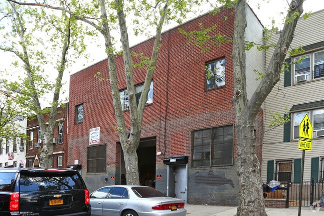
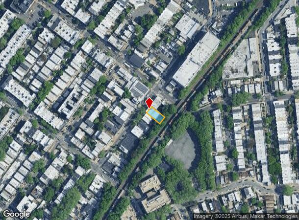
1846 Decatur St, Ridgewood, NY 11385


NEARBY LISTINGS FOR SALE OR LEASE
Property Detail
1846 Decatur St
03579-0045
Estate/John H Rathjan
Warehouse
Queens
X
New York
3604970209F
45
2024
0.12 AC
2025
Central Queens
055700
Long Island (New York)
9,020 SF
New York-Jersey City-White Plains, NY-NJ
DEMOGRAPHICS near 1846 Decatur St
1 Mile
3 Mile
5 Mile
2024 Total Population
96,561
940,206
2,722,476
2029 Population
88,255
873,110
2,552,642
Pop Growth 2024-2029
(8.60%)
(7.14%)
(6.24%)
Average Age
38
38
39
2024 Total Households
33,794
335,194
1,022,830
HH Growth 2024-2029
(9.18%)
(7.56%)
(6.40%)
Median Household Inc
$72,085
$61,539
$71,775
Avg Household Size
2.80
2.70
2.50
2024 Avg HH Vehicles
1.00
1.00
1.00
Median Home Value
$845,511
$760,535
$731,261
Median Year Built
1946
1948
1949
Nearby Places
- Restaurants
- Banks
- Shops
- Fitness
- Groceries
PUBLIC TRANSPORTATION
TRANSIT/SUBWAY
Halsey Street (L Line) (L - New York MTA Subway (The Subway))
DRIVE
WALK
Distance
Halsey Street (L Line) (L - New York MTA Subway (The Subway))
3 min
11 min
0.5 mi
Forest Avenue (M - New York MTA Subway (The Subway))
DRIVE
WALK
Distance
Forest Avenue (M - New York MTA Subway (The Subway))
4 min
12 min
0.6 mi
Seneca Avenue (M - New York MTA Subway (The Subway))
DRIVE
WALK
Distance
Seneca Avenue (M - New York MTA Subway (The Subway))
4 min
13 min
0.7 mi
Fresh Pond Road (M - New York MTA Subway (The Subway))
DRIVE
WALK
Distance
Fresh Pond Road (M - New York MTA Subway (The Subway))
4 min
14 min
0.7 mi
Myrtle-Wyckoff Avenues (L - New York MTA Subway (The Subway), M - New York MTA Subway (The Subway))
DRIVE
WALK
Distance
Myrtle-Wyckoff Avenues (L - New York MTA Subway (The Subway), M - New York MTA Subway (The Subway))
5 min
17 min
0.8 mi
COMMUTER RAIL
East New York Station (Far Rockaway Branch - Long Island Rail Road, Long Beach Branch - Long Island Rail Road, West Hempstead Branch - Long Island Rail Road)
DRIVE
WALK
Distance
East New York Station (Far Rockaway Branch - Long Island Rail Road, Long Beach Branch - Long Island Rail Road, West Hempstead Branch - Long Island Rail Road)
9 min
2.5 mi
Nostrand Avenue Station (Far Rockaway Branch - Long Island Rail Road, Hempstead Branch - Long Island Rail Road, Long Beach Branch - Long Island Rail Road, West Hempstead Branch - Long Island Rail Road)
DRIVE
WALK
Distance
Nostrand Avenue Station (Far Rockaway Branch - Long Island Rail Road, Hempstead Branch - Long Island Rail Road, Long Beach Branch - Long Island Rail Road, West Hempstead Branch - Long Island Rail Road)
17 min
4.0 mi
AIRPORT
John F Kennedy International
DRIVE
WALK
Distance
John F Kennedy International
23 min
9.4 mi
LaGuardia
DRIVE
WALK
Distance
LaGuardia
20 min
11.1 mi
Newark Liberty International
DRIVE
WALK
Distance
Newark Liberty International
44 min
21.9 mi
SALE & LEASE HISTORY
LISTING DATE
SALE/LEASE

Sep 25, 2016
For Lease
Sep 24, 2016
For Sale
May 22, 2018
For Lease
Mar 21, 2017
For Sale
Jan 30, 2018
For Sale
Jan 17, 2019
For Lease
Nearby Properties
Address
Land Use
TOTAL SIZE
Lot Size
Zoning
Address
Land Use
TOTAL SIZE
Lot Size
Zoning
772,163 SF
5.24 AC
C4-5X
Address
Land Use
TOTAL SIZE
Lot Size
Zoning
54,170 SF
229.57 AC
PARK
Address
Land Use
TOTAL SIZE
Lot Size
Zoning
835,231 SF
11.32 AC
R6
Address
Land Use
TOTAL SIZE
Lot Size
Zoning
234,891 SF
3.17 AC
C4-5X
Address
Land Use
TOTAL SIZE
Lot Size
Zoning
126.85 AC
PARK
Address
Land Use
TOTAL SIZE
Lot Size
Zoning
264,691 SF
5.17 AC
M1-2
Address
Land Use
TOTAL SIZE
Lot Size
Zoning
1,000 SF
210.07 AC
R3-2
Address
Land Use
TOTAL SIZE
Lot Size
Zoning
1,572,198 SF
22.06 AC
M1-2
Address
Land Use
TOTAL SIZE
Lot Size
Zoning
344,116 SF
0.92 AC
R7-1
Address
Land Use
TOTAL SIZE
Lot Size
Zoning
826,915 SF
8.83 AC
M3-1
Address
Land Use
TOTAL SIZE
Lot Size
Zoning
446,763 SF
12.52 AC
R6
Address
Land Use
TOTAL SIZE
Lot Size
Zoning
1,150,500 SF
15.17 AC
R6
Address
Land Use
TOTAL SIZE
Lot Size
Zoning
2,193 SF
94.72 AC
PARK
Address
Land Use
TOTAL SIZE
Lot Size
Zoning
360,000 SF
5.88 AC
C4-2
Address
Land Use
TOTAL SIZE
Lot Size
Zoning
307,038 SF
7.84 AC
M1-1
Address
Land Use
TOTAL SIZE
Lot Size
Zoning
474,715 SF
1.72 AC
M14R8A
Address
Land Use
TOTAL SIZE
Lot Size
Zoning
458,778 SF
2.09 AC
R6
Address
Land Use
TOTAL SIZE
Lot Size
Zoning
490,600 SF
12.01 AC
M1-1
Address
Land Use
TOTAL SIZE
Lot Size
Zoning
248,200 SF
1.25 AC
R6
Address
Land Use
TOTAL SIZE
Lot Size
Zoning
257,660 SF
1.94 AC
R7A
Address
Land Use
TOTAL SIZE
Lot Size
Zoning
1,136,208 SF
30.25 AC
R5
Address
Land Use
TOTAL SIZE
Lot Size
Zoning
353,333 SF
1.99 AC
R6A
Address
Land Use
TOTAL SIZE
Lot Size
Zoning
780,000 SF
11.15 AC
R6
Address
Land Use
TOTAL SIZE
Lot Size
Zoning
88,700 SF
4.59 AC
M3-1
Address
Land Use
TOTAL SIZE
Lot Size
Zoning
821,016 SF
8.92 AC
R6
Address
Land Use
TOTAL SIZE
Lot Size
Zoning
220,627 SF
0.79 AC
C4-4
Address
Land Use
TOTAL SIZE
Lot Size
Zoning
388,023 SF
1.58 AC
R7A
Address
Land Use
TOTAL SIZE
Lot Size
Zoning
272,081 SF
4.59 AC
C4-2
Address
Land Use
TOTAL SIZE
Lot Size
Zoning
240,000 SF
2.09 AC
R6
Address
Land Use
TOTAL SIZE
Lot Size
Zoning
574,055 SF
3.33 AC
M1-3
The World's #1 Commercial Real Estate Marketplace
Connect with us
© 2025 CoStar Group
The information above has been obtained from sources believed reliable. While we do not doubt its accuracy we have not verified it and make no guarantee, warranty or representation about it. It is your responsibility to independently confirm its accuracy and completeness. Any projections, opinions, assumptions, or estimates used are for example only and do not represent the current or future performance of the property. The value of this transaction to you depends on tax and other factors which should be evaluated by your tax, financial, and legal advisors. You and your advisors should conduct a careful, independent investigation of the property to determine to your satisfaction the suitability of the property for your needs.