Property Record
18464 Underwood Rd, Foley, AL 36535
NEARBY LISTINGS FOR SALE OR LEASE
Property Detail
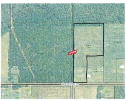
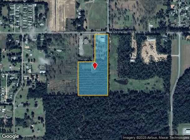
18464 Underwood Rd
54-04-18-0-000-008.001
15 AC(C) E1/2 OF THE NE1/4 OF THE SW1/4 LESS RD R/W ALSO LES S BEG AT A PT SW 302.43' SW OF THE CENTER OF SEC 18 RUN S 59 6.7
Religious
Baldwin
X
Alabama
01003C0812M
15 AC
0
Baldwin County
2024
Mobile
011501
Daphne-Fairhope-Foley, AL
6,569 SF
DEMOGRAPHICS near 18464 Underwood Rd
1 Mile
3 Mile
5 Mile
2024 Total Population
1,706
12,864
26,966
2029 Population
1,953
14,727
31,050
Pop Growth 2024-2029
+ 14.48%
+ 14.48%
+ 15.14%
Average Age
44
42
42
2024 Total Households
694
5,028
10,730
HH Growth 2024-2029
+ 13.98%
+ 14.06%
+ 14.76%
Median Household Inc
$59,452
$57,752
$54,318
Avg Household Size
2.40
2.40
2.40
2024 Avg HH Vehicles
2.00
2.00
2.00
Median Home Value
$240,206
$231,208
$229,247
Median Year Built
2001
1997
1998
Nearby Places
Map Layers
Map Styles
 Street
 Aerial
- Restaurants
- Banks
- Shops
- Fitness
- Groceries
PUBLIC TRANSPORTATION
AIRPORT
Mobile International
DRIVE
WALK
Distance
Mobile International
57 min
40.2 mi
Freight Ports
Port of Mobile
DRIVE
WALK
Distance
Port of Mobile
51 min
36.9 mi
Nearby Properties
Address
Land Use
TOTAL SIZE
Lot Size
Zoning
Address
Land Use
TOTAL SIZE
Lot Size
Zoning
167,962 SF
11 AC
Address
Land Use
TOTAL SIZE
Lot Size
Zoning
1.84 AC
Address
Land Use
TOTAL SIZE
Lot Size
Zoning
105,000 SF
81 AC
Address
Land Use
TOTAL SIZE
Lot Size
Zoning
64,091 SF
13 AC
Address
Land Use
TOTAL SIZE
Lot Size
Zoning
1,125 SF
19 AC
Address
Land Use
TOTAL SIZE
Lot Size
Zoning
30,000 SF
6.20 AC
Address
Land Use
TOTAL SIZE
Lot Size
Zoning
57,431 SF
15 AC
Address
Land Use
TOTAL SIZE
Lot Size
Zoning
26,025 SF
3.95 AC
Address
Land Use
TOTAL SIZE
Lot Size
Zoning
1.46 AC
Address
Land Use
TOTAL SIZE
Lot Size
Zoning
28,002 SF
0.89 AC
Address
Land Use
TOTAL SIZE
Lot Size
Zoning
7,875 SF
6.50 AC
Address
Land Use
TOTAL SIZE
Lot Size
Zoning
36,648 SF
1.29 AC
Address
Land Use
TOTAL SIZE
Lot Size
Zoning
14,934 SF
9.30 AC
Address
Land Use
TOTAL SIZE
Lot Size
Zoning
20,000 SF
35 AC
Address
Land Use
TOTAL SIZE
Lot Size
Zoning
42,337 SF
6.60 AC
Address
Land Use
TOTAL SIZE
Lot Size
Zoning
2,299 SF
4.65 AC
Address
Land Use
TOTAL SIZE
Lot Size
Zoning
44,752 SF
4.26 AC
Address
Land Use
TOTAL SIZE
Lot Size
Zoning
3,404 SF
19 AC
Address
Land Use
TOTAL SIZE
Lot Size
Zoning
15,336 SF
3.72 AC
Address
Land Use
TOTAL SIZE
Lot Size
Zoning
28,955 SF
0.99 AC
Address
Land Use
TOTAL SIZE
Lot Size
Zoning
4,022 SF
11 AC
Address
Land Use
TOTAL SIZE
Lot Size
Zoning
43,362 SF
5 AC
Address
Land Use
TOTAL SIZE
Lot Size
Zoning
8,080 SF
5 AC
Address
Land Use
TOTAL SIZE
Lot Size
Zoning
45,100 SF
15 AC
Address
Land Use
TOTAL SIZE
Lot Size
Zoning
42,517 SF
6 AC
Address
Land Use
TOTAL SIZE
Lot Size
Zoning
1,400 SF
5.50 AC
Address
Land Use
TOTAL SIZE
Lot Size
Zoning
11,356 SF
0.69 AC
Address
Land Use
TOTAL SIZE
Lot Size
Zoning
0.60 AC
Address
Land Use
TOTAL SIZE
Lot Size
Zoning
171,820 SF
8.60 AC
Address
Land Use
TOTAL SIZE
Lot Size
Zoning
53,454 SF
5.50 AC
The World's #1 Commercial Real Estate Marketplace
Connect with us
© 2026 CoStar Group
The information above has been obtained from sources believed reliable. While we do not doubt its accuracy we have not verified it and make no guarantee, warranty or representation about it. It is your responsibility to independently confirm its accuracy and completeness. Any projections, opinions, assumptions, or estimates used are for example only and do not represent the current or future performance of the property. The value of this transaction to you depends on tax and other factors which should be evaluated by your tax, financial, and legal advisors. You and your advisors should conduct a careful, independent investigation of the property to determine to your satisfaction the suitability of the property for your needs.