Property Record
18465 W Colfax Ave, Lakewood, CO 80401

NEARBY LISTINGS FOR SALE OR LEASE
Property Detail
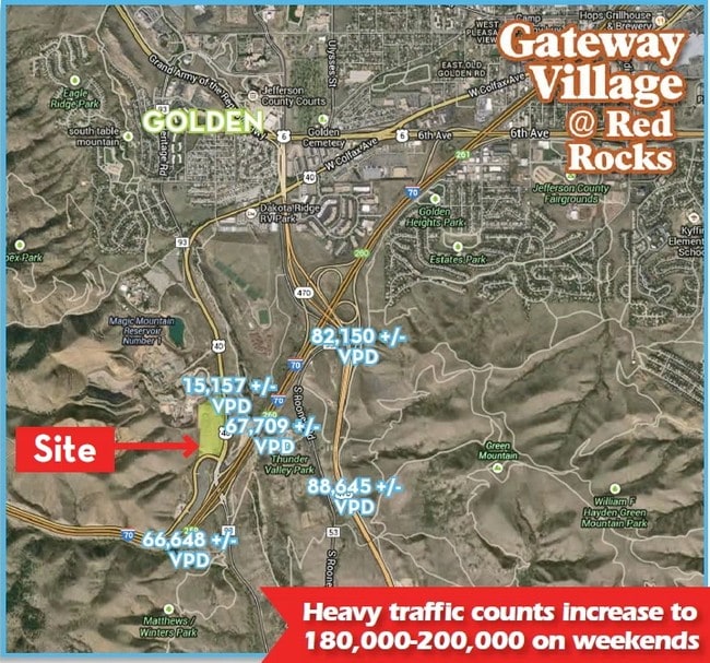
18465 W Colfax Ave
Denver-Aurora-Lakewood, CO
Gateway Village Flg 1 Amd & Ratified Fin
40-154-01-020
SECTION 15 TOWNSHIP 04 RANGE 70 SUBDIVISIONCD 269362 SUBDIVISIONNAME GATEWAY VILLAGE FLG 1 AMD & RATIFIED FINAL PLAT 1ST AMD REPLAT 1 LOT 0008 SIZE: 82037 VALUE: 1.883
Vacantlandnec
Jefferson
X
Colorado
08059C0279F
8
2023
1.88 AC
2024
West
009855
Denver
6,612 SF
DEMOGRAPHICS near 18465 W Colfax Ave
1 Mile
3 Mile
5 Mile
2024 Total Population
340
25,488
91,952
2029 Population
343
25,229
91,082
Pop Growth 2024-2029
+ 0.88%
(1.02%)
(0.95%)
Average Age
41
41
41
2024 Total Households
124
10,099
38,233
HH Growth 2024-2029
+ 0.81%
(1.09%)
(0.97%)
Median Household Inc
$165,151
$113,118
$98,373
Avg Household Size
2.70
2.40
2.30
2024 Avg HH Vehicles
3.00
2.00
2.00
Median Home Value
$764,999
$670,554
$637,006
Median Year Built
1997
1985
1978
Nearby Places
Map Layers
Map Styles
 Street
 Aerial
- Restaurants
- Banks
- Shops
- Fitness
- Groceries
PUBLIC TRANSPORTATION
COMMUTER RAIL
Wheat Ridge - Ward Station Track 1 (Union Station to Wheat Ridge Ward Station - Regional Transportation District)
DRIVE
WALK
Distance
Wheat Ridge - Ward Station Track 1 (Union Station to Wheat Ridge Ward Station - Regional Transportation District)
13 min
9.0 mi
Freight Ports
Tulsa Port Of Catoosa
DRIVE
WALK
Distance
Tulsa Port Of Catoosa
744 min
723.1 mi
Nearby Properties
Address
Land Use
TOTAL SIZE
Lot Size
Zoning
Address
Land Use
TOTAL SIZE
Lot Size
Zoning
Address
Land Use
TOTAL SIZE
Lot Size
Zoning
367,452 SF
38.94 AC
Address
Land Use
TOTAL SIZE
Lot Size
Zoning
420,482 SF
66.03 AC
Address
Land Use
TOTAL SIZE
Lot Size
Zoning
352,259 SF
17.94 AC
Address
Land Use
TOTAL SIZE
Lot Size
Zoning
Address
Land Use
TOTAL SIZE
Lot Size
Zoning
188,554 SF
33.28 AC
Address
Land Use
TOTAL SIZE
Lot Size
Zoning
198,147 SF
2.55 AC
Address
Land Use
TOTAL SIZE
Lot Size
Zoning
118,522 SF
7.07 AC
PD
Address
Land Use
TOTAL SIZE
Lot Size
Zoning
55,030 SF
4.94 AC
Address
Land Use
TOTAL SIZE
Lot Size
Zoning
68,773 SF
9.90 AC
Address
Land Use
TOTAL SIZE
Lot Size
Zoning
139,919 SF
6.51 AC
PD
Address
Land Use
TOTAL SIZE
Lot Size
Zoning
120,967 SF
9.54 AC
Address
Land Use
TOTAL SIZE
Lot Size
Zoning
129,753 SF
11.40 AC
Address
Land Use
TOTAL SIZE
Lot Size
Zoning
109,428 SF
12.76 AC
Address
Land Use
TOTAL SIZE
Lot Size
Zoning
67,473 SF
6.90 AC
Address
Land Use
TOTAL SIZE
Lot Size
Zoning
57,434 SF
5.19 AC
Address
Land Use
TOTAL SIZE
Lot Size
Zoning
206,151 SF
7.67 AC
Address
Land Use
TOTAL SIZE
Lot Size
Zoning
190,874 SF
17.36 AC
Address
Land Use
TOTAL SIZE
Lot Size
Zoning
90,663 SF
56.05 AC
Address
Land Use
TOTAL SIZE
Lot Size
Zoning
81,868 SF
11.88 AC
A1
Address
Land Use
TOTAL SIZE
Lot Size
Zoning
270,527 SF
16.11 AC
Address
Land Use
TOTAL SIZE
Lot Size
Zoning
173,500 SF
5.16 AC
Address
Land Use
TOTAL SIZE
Lot Size
Zoning
266.38 AC
A2
Address
Land Use
TOTAL SIZE
Lot Size
Zoning
148,038 SF
67.84 AC
Address
Land Use
TOTAL SIZE
Lot Size
Zoning
72,164 SF
8 AC
R2
Address
Land Use
TOTAL SIZE
Lot Size
Zoning
96,092 SF
6.82 AC
Address
Land Use
TOTAL SIZE
Lot Size
Zoning
251.42 AC
A2
Address
Land Use
TOTAL SIZE
Lot Size
Zoning
114,027 SF
16.87 AC
MH
Address
Land Use
TOTAL SIZE
Lot Size
Zoning
39,277 SF
11.13 AC
Address
Land Use
TOTAL SIZE
Lot Size
Zoning
73,067 SF
6.03 AC
The World's #1 Commercial Real Estate Marketplace
Connect with us
© 2026 CoStar Group
The information above has been obtained from sources believed reliable. While we do not doubt its accuracy we have not verified it and make no guarantee, warranty or representation about it. It is your responsibility to independently confirm its accuracy and completeness. Any projections, opinions, assumptions, or estimates used are for example only and do not represent the current or future performance of the property. The value of this transaction to you depends on tax and other factors which should be evaluated by your tax, financial, and legal advisors. You and your advisors should conduct a careful, independent investigation of the property to determine to your satisfaction the suitability of the property for your needs.