Property Record
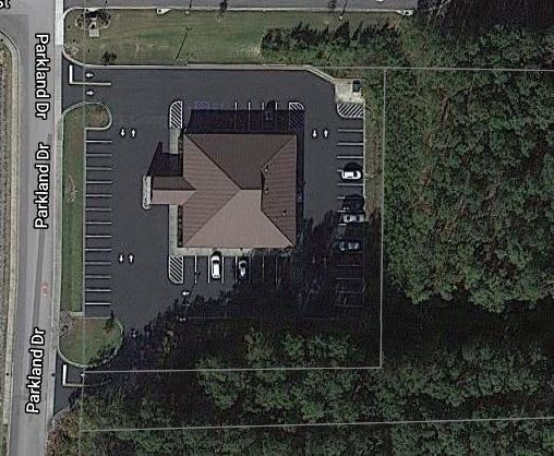
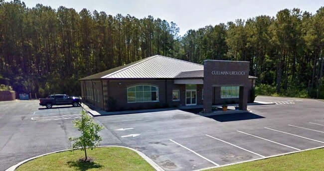
1848 Parkland Dr Ne, Cullman, AL 35058

Property Detail
1848 Parkland Dr Ne
Cullman, AL
1.10 AC, BEG 312.28 W, 209.08 S & 199.96 W NE COR SW1/4 NE1/4, TH W 219.74 TO E/ROW PARK LAND DR, TH S ALG ROW 226.64, E 220.
17-01-01-0-000-002.017
Cullman
Medicalbuilding
Alabama
B and X Area of moderate flood hazard, usually the area between the limits of the 100-year and 500-year floods.
1
2025
1.10 AC
2025
Alabama North Area
964902
Other Market Areas
6,724 SF
NEARBY LISTINGS FOR SALE OR LEASE
DEMOGRAPHICS near 1848 Parkland Dr Ne
1 mile
3 mile
5 mile
2025 Total Population
595
9,094
27,798
2030 Population
614
9,364
28,618
Pop Growth 2025-2030
+ 3.19%
+ 2.97%
+ 2.95%
Average Age
42
41
41
2025 Total Households
218
3,476
11,145
HH Growth 2025-2030
+ 3.21%
+ 2.96%
+ 2.84%
Median Household Inc
$77,174
$70,756
$57,815
Avg Household Size
2.60
2.50
2.40
2025 Avg HH Vehicles
3.00
2.00
2.00
Median Home Value
$286,734
$247,980
$234,460
Median Year Built
1989
1979
1977
Nearby Places
Map Layers
Map Styles
 Street
 Aerial
Layers
 Traffic
 Biking
Places
Listings with unknown addresses are not visible on the map
- Restaurants
- Banks
- Shops
- Fitness
- Groceries
PUBLIC TRANSPORTATION
AIRPORT
Huntsville International-Carl T Jones Field
Drive
Walk
Distance
Huntsville International-Carl T Jones Field
56 min
44.8 mi
SALE & LEASE HISTORY
LISTING DATE
SALE/LEASE

Feb 11, 2025
For Sale
Nearby Properties
Address
Land Use
TOTAL SIZE
Lot Size
Zoning
Address
Land Use
TOTAL SIZE
Lot Size
Zoning
10,938 SF
25 AC
Address
Land Use
TOTAL SIZE
Lot Size
Zoning
10,104 SF
112 AC
Address
Land Use
TOTAL SIZE
Lot Size
Zoning
28,800 SF
22 AC
Address
Land Use
TOTAL SIZE
Lot Size
Zoning
3,522 SF
100 AC
Address
Land Use
TOTAL SIZE
Lot Size
Zoning
7,344 SF
397 AC
Address
Land Use
TOTAL SIZE
Lot Size
Zoning
22 AC
Address
Land Use
TOTAL SIZE
Lot Size
Zoning
5,892 SF
26.30 AC
Address
Land Use
TOTAL SIZE
Lot Size
Zoning
11,280 SF
28.27 AC
Address
Land Use
TOTAL SIZE
Lot Size
Zoning
29,653 SF
Address
Land Use
TOTAL SIZE
Lot Size
Zoning
7,516 SF
1.09 AC
Address
Land Use
TOTAL SIZE
Lot Size
Zoning
0.60 AC
Address
Land Use
TOTAL SIZE
Lot Size
Zoning
Address
Land Use
TOTAL SIZE
Lot Size
Zoning
9,492 SF
1.82 AC
Address
Land Use
TOTAL SIZE
Lot Size
Zoning
2,580 SF
0.39 AC
Address
Land Use
TOTAL SIZE
Lot Size
Zoning
Address
Land Use
TOTAL SIZE
Lot Size
Zoning
15,912 SF
1.50 AC
Address
Land Use
TOTAL SIZE
Lot Size
Zoning
7,212 SF
20 AC
Address
Land Use
TOTAL SIZE
Lot Size
Zoning
20,104 SF
Address
Land Use
TOTAL SIZE
Lot Size
Zoning
42,221 SF
2.70 AC
Address
Land Use
TOTAL SIZE
Lot Size
Zoning
17,700 SF
6.70 AC
Address
Land Use
TOTAL SIZE
Lot Size
Zoning
31,217 SF
15 AC
Address
Land Use
TOTAL SIZE
Lot Size
Zoning
18,300 SF
0.50 AC
Address
Land Use
TOTAL SIZE
Lot Size
Zoning
3,754 SF
9.30 AC
Address
Land Use
TOTAL SIZE
Lot Size
Zoning
25,837 SF
5.99 AC
Address
Land Use
TOTAL SIZE
Lot Size
Zoning
27,022 SF
2 AC
Address
Land Use
TOTAL SIZE
Lot Size
Zoning
42,244 SF
8.90 AC
Address
Land Use
TOTAL SIZE
Lot Size
Zoning
5,304 SF
4.10 AC
Address
Land Use
TOTAL SIZE
Lot Size
Zoning
3,828 SF
5 AC
Address
Land Use
TOTAL SIZE
Lot Size
Zoning
6,984 SF
1.49 AC
Address
Land Use
TOTAL SIZE
Lot Size
Zoning
4,228 SF
0.47 AC
The World's #1 Commercial Real Estate Marketplace
Connect with us
© 2026 CoStar Group
The information above has been obtained from sources believed reliable. While we do not doubt its accuracy we have not verified it and make no guarantee, warranty or representation about it. It is your responsibility to independently confirm its accuracy and completeness. Any projections, opinions, assumptions, or estimates used are for example only and do not represent the current or future performance of the property. The value of this transaction to you depends on tax and other factors which should be evaluated by your tax, financial, and legal advisors. You and your advisors should conduct a careful, independent investigation of the property to determine to your satisfaction the suitability of the property for your needs.