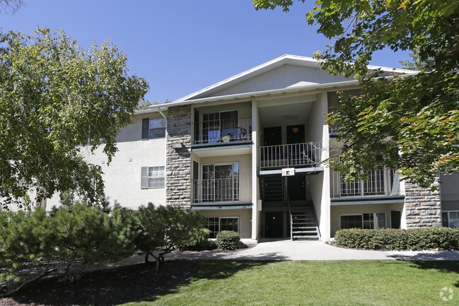
Property Record
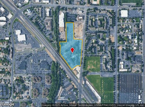
1849 N Freedom Blvd, Provo, UT 84604


NEARBY LISTINGS FOR SALE OR LEASE
Property Detail
1849 N Freedom Blvd
Provo-Orem, UT
COM N 88 DEG 41 48 E 775.92 FT FR N 1/4 COR. SEC. 36, T6S, R2E, SLB&M.; S 88 DEG 41 48 W 17.52 FT; N 4 DEG 14 0 W 83.91 FT; N 88 DEG 46 13 E 170.33 FT; N 1 DEG 3 8 W 482.05 FT; S 89 DEG 44 13 E 190.05 FT; S 1 DEG 3 8 E 407.84 FT; S 85 DEG 46 12 E 219
19-069-0020
Utah
Apartment
Utah
2024
9.29 AC
2025
Riverside
001401
Salt Lake City
118,816 SF
DEMOGRAPHICS near 1849 N Freedom Blvd
1 Mile
3 Mile
5 Mile
2024 Total Population
19,925
146,364
221,711
2029 Population
23,227
170,886
259,013
Pop Growth 2024-2029
+ 16.57%
+ 16.75%
+ 16.82%
Average Age
29
31
31
2024 Total Households
5,970
45,764
69,049
HH Growth 2024-2029
+ 17.10%
+ 17.19%
+ 17.32%
Median Household Inc
$55,070
$61,175
$65,105
Avg Household Size
2.90
3.00
3.00
2024 Avg HH Vehicles
2.00
2.00
2.00
Median Home Value
$459,577
$450,449
$429,811
Median Year Built
1984
1983
1987
Nearby Places
Map Layers
Map Styles
 Street
 Aerial
- Restaurants
- Banks
- Shops
- Fitness
- Groceries
PUBLIC TRANSPORTATION
COMMUTER RAIL
Provo Central Station (FrontRunner - Utah Transit Authority (UTA))
DRIVE
WALK
Distance
Provo Central Station (FrontRunner - Utah Transit Authority (UTA))
4 min
2.6 mi
Provo Amtrak (California Zephyr - Amtrak)
DRIVE
WALK
Distance
Provo Amtrak (California Zephyr - Amtrak)
5 min
2.8 mi
AIRPORT
Provo Municipal
DRIVE
WALK
Distance
Provo Municipal
12 min
7.2 mi
Freight Ports
Port of Stockton
DRIVE
WALK
Distance
Port of Stockton
757 min
738.1 mi
Nearby Properties
Address
Land Use
TOTAL SIZE
Lot Size
Zoning
Address
Land Use
TOTAL SIZE
Lot Size
Zoning
1,744,846 SF
19.25 AC
Address
Land Use
TOTAL SIZE
Lot Size
Zoning
347,829 SF
5.26 AC
Address
Land Use
TOTAL SIZE
Lot Size
Zoning
1,003,185 SF
9.57 AC
Address
Land Use
TOTAL SIZE
Lot Size
Zoning
623,237 SF
14.06 AC
Address
Land Use
TOTAL SIZE
Lot Size
Zoning
530,326 SF
8.14 AC
Address
Land Use
TOTAL SIZE
Lot Size
Zoning
222,763 SF
10.71 AC
Address
Land Use
TOTAL SIZE
Lot Size
Zoning
366,509 SF
2.83 AC
Address
Land Use
TOTAL SIZE
Lot Size
Zoning
627,022 SF
9.16 AC
Address
Land Use
TOTAL SIZE
Lot Size
Zoning
310,818 SF
1.17 AC
Address
Land Use
TOTAL SIZE
Lot Size
Zoning
371,881 SF
4.91 AC
Address
Land Use
TOTAL SIZE
Lot Size
Zoning
219,346 SF
2.20 AC
Address
Land Use
TOTAL SIZE
Lot Size
Zoning
199,119 SF
17.18 AC
Address
Land Use
TOTAL SIZE
Lot Size
Zoning
323,674 SF
13.81 AC
Address
Land Use
TOTAL SIZE
Lot Size
Zoning
122,784 SF
12.46 AC
Address
Land Use
TOTAL SIZE
Lot Size
Zoning
245,657 SF
5.60 AC
Address
Land Use
TOTAL SIZE
Lot Size
Zoning
212,820 SF
12.90 AC
Address
Land Use
TOTAL SIZE
Lot Size
Zoning
401,381 SF
3.50 AC
Address
Land Use
TOTAL SIZE
Lot Size
Zoning
154,685 SF
13.20 AC
Address
Land Use
TOTAL SIZE
Lot Size
Zoning
222,803 SF
18.48 AC
Address
Land Use
TOTAL SIZE
Lot Size
Zoning
268,060 SF
11.73 AC
Address
Land Use
TOTAL SIZE
Lot Size
Zoning
311,697 SF
6.49 AC
Address
Land Use
TOTAL SIZE
Lot Size
Zoning
107,840 SF
0.98 AC
Address
Land Use
TOTAL SIZE
Lot Size
Zoning
124,242 SF
9.33 AC
Address
Land Use
TOTAL SIZE
Lot Size
Zoning
266,387 SF
1.76 AC
Address
Land Use
TOTAL SIZE
Lot Size
Zoning
174,883 SF
17.42 AC
Address
Land Use
TOTAL SIZE
Lot Size
Zoning
269,652 SF
3.65 AC
Address
Land Use
TOTAL SIZE
Lot Size
Zoning
155,726 SF
13.64 AC
Address
Land Use
TOTAL SIZE
Lot Size
Zoning
300,810 SF
7.32 AC
Address
Land Use
TOTAL SIZE
Lot Size
Zoning
208,492 SF
12.49 AC
The World's #1 Commercial Real Estate Marketplace
Connect with us
© 2026 CoStar Group
The information above has been obtained from sources believed reliable. While we do not doubt its accuracy we have not verified it and make no guarantee, warranty or representation about it. It is your responsibility to independently confirm its accuracy and completeness. Any projections, opinions, assumptions, or estimates used are for example only and do not represent the current or future performance of the property. The value of this transaction to you depends on tax and other factors which should be evaluated by your tax, financial, and legal advisors. You and your advisors should conduct a careful, independent investigation of the property to determine to your satisfaction the suitability of the property for your needs.