Property Record
184Th Ave, Bristol, WI 53104
NEARBY LISTINGS FOR SALE OR LEASE
-
-
View all Bristol listings for sale on LoopNet.com
Property Detail
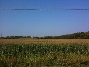
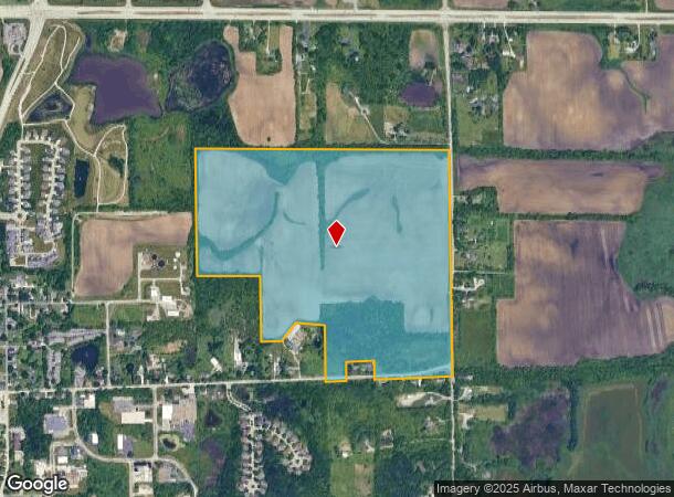
184Th Ave
Kenosha, WI
118-B S 1/2 NE 1/4 SEC 8 T 1 R 21 ALSO PT NW 1/4 SE 1/4 COM 661. 495 FT E OF NW COR TO BEG TH E 667 FT S 517.595 FT TH S 86 D
37-4-121-081-0400
Kenosha
Vacantlandnec
Wisconsin
X
0
55059C0166D
118.77 AC
2024
Kenosha East
2024
Chicago
002700
DEMOGRAPHICS near 184Th Ave
1 mile
3 mile
5 mile
2024 Total Population
1,257
5,475
19,155
2029 Population
1,244
5,490
19,234
Pop Growth 2024-2029
(1.03%)
+ 0.27%
+ 0.41%
Average Age
39
40
41
2024 Total Households
468
2,076
7,369
HH Growth 2024-2029
(1.07%)
+ 0.14%
+ 0.35%
Median Household Inc
$122,964
$119,283
$92,142
Avg Household Size
2.70
2.60
2.60
2024 Avg HH Vehicles
3.00
3.00
2.00
Median Home Value
$344,776
$390,252
$300,848
Median Year Built
1977
1989
1989
Nearby Places
Map Layers
Map Styles
 Street
 Aerial
Transit
 Traffic
 Biking
Places
Listings with unknown addresses are not visible on the map
- Restaurants
- Banks
- Shops
- Fitness
- Groceries
PUBLIC TRANSPORTATION
AIRPORT
General Mitchell International
Drive
Walk
Distance
General Mitchell International
40 min
32.6 mi
Freight Ports
Port Milwaukee
Drive
Walk
Distance
Port Milwaukee
45 min
36.5 mi
Nearby Properties
Address
Land Use
TOTAL SIZE
Lot Size
Zoning
Address
Land Use
TOTAL SIZE
Lot Size
Zoning
106,740 SF
7.34 AC
Address
Land Use
TOTAL SIZE
Lot Size
Zoning
11,324 SF
7.94 AC
Address
Land Use
TOTAL SIZE
Lot Size
Zoning
3,040 SF
145.82 AC
Address
Land Use
TOTAL SIZE
Lot Size
Zoning
8,112 SF
146 AC
Address
Land Use
TOTAL SIZE
Lot Size
Zoning
9,659 SF
3.73 AC
B2
Address
Land Use
TOTAL SIZE
Lot Size
Zoning
1,082 SF
142.60 AC
Address
Land Use
TOTAL SIZE
Lot Size
Zoning
95 AC
Address
Land Use
TOTAL SIZE
Lot Size
Zoning
5.04 AC
Address
Land Use
TOTAL SIZE
Lot Size
Zoning
5,423 SF
57.31 AC
Address
Land Use
TOTAL SIZE
Lot Size
Zoning
16,800 SF
4.60 AC
Address
Land Use
TOTAL SIZE
Lot Size
Zoning
5,376 SF
4.92 AC
Address
Land Use
TOTAL SIZE
Lot Size
Zoning
4,810 SF
6.17 AC
Address
Land Use
TOTAL SIZE
Lot Size
Zoning
6,432 SF
1.96 AC
Address
Land Use
TOTAL SIZE
Lot Size
Zoning
17,946 SF
5.81 AC
Address
Land Use
TOTAL SIZE
Lot Size
Zoning
13,020 SF
2.46 AC
Address
Land Use
TOTAL SIZE
Lot Size
Zoning
8,910 SF
10.02 AC
Address
Land Use
TOTAL SIZE
Lot Size
Zoning
7,686 SF
5.73 AC
Address
Land Use
TOTAL SIZE
Lot Size
Zoning
1,616 SF
17.64 AC
Address
Land Use
TOTAL SIZE
Lot Size
Zoning
9,644 SF
1.84 AC
Address
Land Use
TOTAL SIZE
Lot Size
Zoning
6,853 SF
74.10 AC
Address
Land Use
TOTAL SIZE
Lot Size
Zoning
8,260 SF
22.18 AC
Address
Land Use
TOTAL SIZE
Lot Size
Zoning
1,920 SF
1.56 AC
Address
Land Use
TOTAL SIZE
Lot Size
Zoning
18,225 SF
103.60 AC
Address
Land Use
TOTAL SIZE
Lot Size
Zoning
7,131 SF
40.51 AC
Address
Land Use
TOTAL SIZE
Lot Size
Zoning
6,444 SF
1.46 AC
Address
Land Use
TOTAL SIZE
Lot Size
Zoning
5,734 SF
0.97 AC
Address
Land Use
TOTAL SIZE
Lot Size
Zoning
2,521 SF
78.25 AC
Address
Land Use
TOTAL SIZE
Lot Size
Zoning
5,837 SF
1.45 AC
Address
Land Use
TOTAL SIZE
Lot Size
Zoning
2,742 SF
2.54 AC
Address
Land Use
TOTAL SIZE
Lot Size
Zoning
960 SF
47.30 AC
The World's #1 Commercial Real Estate Marketplace
Connect with us
© 2026 CoStar Group
The information above has been obtained from sources believed reliable. While we do not doubt its accuracy we have not verified it and make no guarantee, warranty or representation about it. It is your responsibility to independently confirm its accuracy and completeness. Any projections, opinions, assumptions, or estimates used are for example only and do not represent the current or future performance of the property. The value of this transaction to you depends on tax and other factors which should be evaluated by your tax, financial, and legal advisors. You and your advisors should conduct a careful, independent investigation of the property to determine to your satisfaction the suitability of the property for your needs.