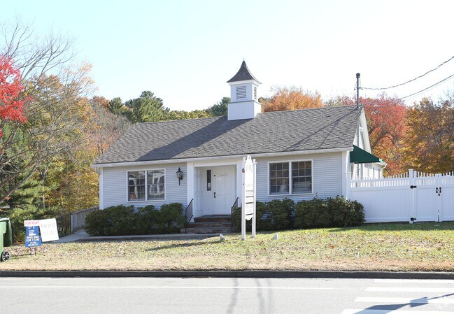
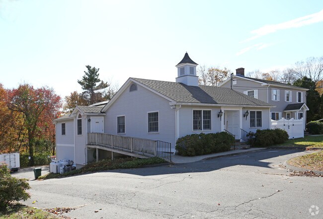
Property Record
185 Boston Post Rd, Old Lyme, CT 06371

Property Detail
185 Boston Post Rd
OLYM-000063-000000-000132
Lower Ct River Vly
Commercialofficeresidentialmixeduse
Connecticut
C-30
132
C and X Area of minimal flood hazard, usually depicted on FIRMs as above the 500-year flood level.
0.93 AC
2025
SW New London/East Lyme
2025
Hartford
660103
Norwich-New London-Willimantic, CT
NEARBY LISTINGS FOR SALE OR LEASE
DEMOGRAPHICS near 185 Boston Post Rd
1 mile
3 mile
5 mile
2025 Total Population
1,687
6,027
26,497
2030 Population
1,711
6,109
27,282
Pop Growth 2025-2030
+ 1.42%
+ 1.36%
+ 2.96%
Average Age
48
47
47
2025 Total Households
725
2,449
10,949
HH Growth 2025-2030
+ 1.38%
+ 1.27%
+ 3.14%
Median Household Inc
$106,325
$128,504
$124,251
Avg Household Size
2.30
2.40
2.30
2025 Avg HH Vehicles
2.00
2.00
2.00
Median Home Value
$414,368
$515,607
$473,633
Median Year Built
1970
1972
1971
Nearby Places
Map Layers
Map Styles
 Street
 Aerial
Layers
 Traffic
 Biking
Places
Listings with unknown addresses are not visible on the map
- Restaurants
- Banks
- Shops
- Fitness
- Groceries
PUBLIC TRANSPORTATION
COMMUTER RAIL
Old Saybrook (Shore Line East - Shore Line East)
Drive
Walk
Distance
Old Saybrook (Shore Line East - Shore Line East)
10 min
6.1 mi
Westbrook (Commuter Rail - Shore Line East)
Drive
Walk
Distance
Westbrook (Commuter Rail - Shore Line East)
13 min
9.6 mi
Freight Ports
Port of New Haven
Drive
Walk
Distance
Port of New Haven
43 min
34.0 mi
Nearby Properties
Address
Land Use
TOTAL SIZE
Lot Size
Zoning
Address
Land Use
TOTAL SIZE
Lot Size
Zoning
44.21 AC
RU80
Address
Land Use
TOTAL SIZE
Lot Size
Zoning
12.34 AC
RU40
Address
Land Use
TOTAL SIZE
Lot Size
Zoning
12.35 AC
C-30
Address
Land Use
TOTAL SIZE
Lot Size
Zoning
106 AC
R40
Address
Land Use
TOTAL SIZE
Lot Size
Zoning
122,580 SF
15.18 AC
Address
Land Use
TOTAL SIZE
Lot Size
Zoning
11.80 AC
RU40
Address
Land Use
TOTAL SIZE
Lot Size
Zoning
13.80 AC
RU80
Address
Land Use
TOTAL SIZE
Lot Size
Zoning
3.58 AC
RU40
Address
Land Use
TOTAL SIZE
Lot Size
Zoning
5,713 SF
5.21 AC
RU80
Address
Land Use
TOTAL SIZE
Lot Size
Zoning
12,682 SF
3.81 AC
RU40
Address
Land Use
TOTAL SIZE
Lot Size
Zoning
11.62 AC
LI80
Address
Land Use
TOTAL SIZE
Lot Size
Zoning
25,088 SF
8.10 AC
LI80
Address
Land Use
TOTAL SIZE
Lot Size
Zoning
4,514 SF
1.10 AC
R-15
Address
Land Use
TOTAL SIZE
Lot Size
Zoning
5.22 AC
C-30
Address
Land Use
TOTAL SIZE
Lot Size
Zoning
15,876 SF
1.14 AC
R-15
Address
Land Use
TOTAL SIZE
Lot Size
Zoning
20,230 SF
1.55 AC
R-15
Address
Land Use
TOTAL SIZE
Lot Size
Zoning
1,026.80 AC
R40
Address
Land Use
TOTAL SIZE
Lot Size
Zoning
29,920 SF
7.64 AC
LI80
Address
Land Use
TOTAL SIZE
Lot Size
Zoning
1.18 AC
WF20
Address
Land Use
TOTAL SIZE
Lot Size
Zoning
3.73 AC
RU40
Address
Land Use
TOTAL SIZE
Lot Size
Zoning
13,858 SF
1.15 AC
C-30
Address
Land Use
TOTAL SIZE
Lot Size
Zoning
2.90 AC
RU80
Address
Land Use
TOTAL SIZE
Lot Size
Zoning
2,544 SF
124.90 AC
Address
Land Use
TOTAL SIZE
Lot Size
Zoning
9.04 AC
RU80
Address
Land Use
TOTAL SIZE
Lot Size
Zoning
125.29 AC
RU80
Address
Land Use
TOTAL SIZE
Lot Size
Zoning
29,880 SF
3.84 AC
LI
Address
Land Use
TOTAL SIZE
Lot Size
Zoning
13.60 AC
RU40
Address
Land Use
TOTAL SIZE
Lot Size
Zoning
1.72 AC
C-30
Address
Land Use
TOTAL SIZE
Lot Size
Zoning
11,473 SF
1.87 AC
I-40
Address
Land Use
TOTAL SIZE
Lot Size
Zoning
24,098 SF
4.46 AC
LI80
The World's #1 Commercial Real Estate Marketplace
Connect with us
© 2026 CoStar Group
The information above has been obtained from sources believed reliable. While we do not doubt its accuracy we have not verified it and make no guarantee, warranty or representation about it. It is your responsibility to independently confirm its accuracy and completeness. Any projections, opinions, assumptions, or estimates used are for example only and do not represent the current or future performance of the property. The value of this transaction to you depends on tax and other factors which should be evaluated by your tax, financial, and legal advisors. You and your advisors should conduct a careful, independent investigation of the property to determine to your satisfaction the suitability of the property for your needs.