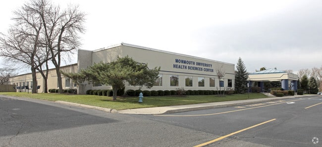
Property Record
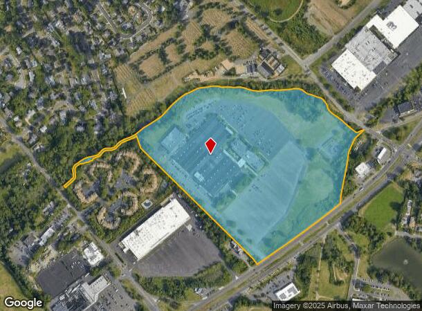
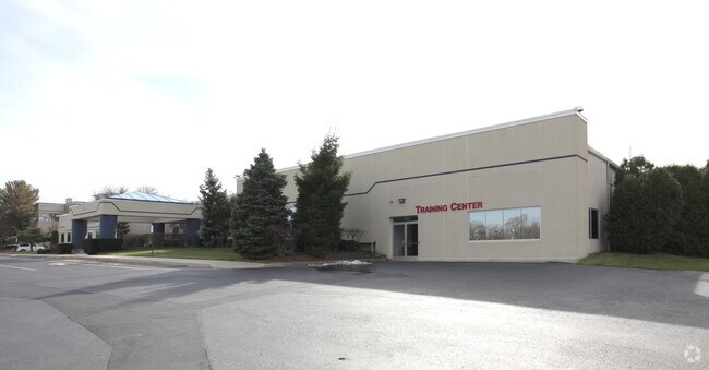
185 Highway 36, West Long Branch, NJ 07764
NEARBY LISTINGS FOR SALE OR LEASE
Property Detail
185 Highway 36
53-00069-0000-00008
L5
Commercialnec
Monmouth
AE
New Jersey
34025C0192F
5
2024
37.52 AC
2025
Eastern Monmouth
806202
Northern New Jersey
331,395 SF
New York-Jersey City-White Plains, NY-NJ
DEMOGRAPHICS near 185 Highway 36
1 Mile
3 Mile
5 Mile
2024 Total Population
6,252
82,336
148,771
2029 Population
6,176
82,299
148,949
Pop Growth 2024-2029
(1.22%)
(0.04%)
+ 0.12%
Average Age
43
41
42
2024 Total Households
2,475
31,624
57,714
HH Growth 2024-2029
(1.54%)
(0.16%)
+ 0.02%
Median Household Inc
$101,260
$84,295
$99,760
Avg Household Size
2.50
2.50
2.50
2024 Avg HH Vehicles
2.00
2.00
2.00
Median Home Value
$490,232
$550,582
$601,304
Median Year Built
1969
1971
1969
Nearby Places
Map Layers
Map Styles
 Street
 Aerial
- Restaurants
- Banks
- Shops
- Fitness
- Groceries
PUBLIC TRANSPORTATION
COMMUTER RAIL
Monmouth Park (North Jersey Coast Line - NJ Transit Commuter Rail (NJ Transit))
DRIVE
WALK
Distance
Monmouth Park (North Jersey Coast Line - NJ Transit Commuter Rail (NJ Transit))
5 min
2.0 mi
Little Silver (North Jersey Coast Line - NJ Transit Commuter Rail (NJ Transit))
DRIVE
WALK
Distance
Little Silver (North Jersey Coast Line - NJ Transit Commuter Rail (NJ Transit))
7 min
2.7 mi
AIRPORT
Newark Liberty International
DRIVE
WALK
Distance
Newark Liberty International
58 min
46.7 mi
Freight Ports
New York Container Terminal
DRIVE
WALK
Distance
New York Container Terminal
52 min
38.8 mi
Nearby Properties
Address
Land Use
TOTAL SIZE
Lot Size
Zoning
Address
Land Use
TOTAL SIZE
Lot Size
Zoning
13.75 AC
M
Address
Land Use
TOTAL SIZE
Lot Size
Zoning
221.56 AC
P1
Address
Land Use
TOTAL SIZE
Lot Size
Zoning
75.16 AC
R-7
Address
Land Use
TOTAL SIZE
Lot Size
Zoning
89,939 SF
51.49 AC
I
Address
Land Use
TOTAL SIZE
Lot Size
Zoning
279,346 SF
3.59 AC
P/VC
Address
Land Use
TOTAL SIZE
Lot Size
Zoning
267,887 SF
13.45 AC
HC
Address
Land Use
TOTAL SIZE
Lot Size
Zoning
35.50 AC
R-7
Address
Land Use
TOTAL SIZE
Lot Size
Zoning
Address
Land Use
TOTAL SIZE
Lot Size
Zoning
136.40 AC
B2
Address
Land Use
TOTAL SIZE
Lot Size
Zoning
22,877 SF
10.35 AC
IC
Address
Land Use
TOTAL SIZE
Lot Size
Zoning
84,653 SF
20.79 AC
B-2
Address
Land Use
TOTAL SIZE
Lot Size
Zoning
194,784 SF
2.88 AC
P/VC
Address
Land Use
TOTAL SIZE
Lot Size
Zoning
2,446 SF
21.62 AC
R-5
Address
Land Use
TOTAL SIZE
Lot Size
Zoning
293,262 SF
28.40 AC
HC
Address
Land Use
TOTAL SIZE
Lot Size
Zoning
24.45 AC
R10A
Address
Land Use
TOTAL SIZE
Lot Size
Zoning
314,569 SF
22.05 AC
R-4
Address
Land Use
TOTAL SIZE
Lot Size
Zoning
79,391 SF
9.17 AC
C-4
Address
Land Use
TOTAL SIZE
Lot Size
Zoning
5,904 SF
29.80 AC
S-2
Address
Land Use
TOTAL SIZE
Lot Size
Zoning
194,812 SF
55.01 AC
R-4
Address
Land Use
TOTAL SIZE
Lot Size
Zoning
35.98 AC
R10A
Address
Land Use
TOTAL SIZE
Lot Size
Zoning
178,315 SF
24.54 AC
3713
Address
Land Use
TOTAL SIZE
Lot Size
Zoning
2.19 AC
BG
Address
Land Use
TOTAL SIZE
Lot Size
Zoning
137,672 SF
2.79 AC
BS
Address
Land Use
TOTAL SIZE
Lot Size
Zoning
27 AC
R10A
Address
Land Use
TOTAL SIZE
Lot Size
Zoning
20.62 AC
AR3P
Address
Land Use
TOTAL SIZE
Lot Size
Zoning
153,160 SF
10.12 AC
BP2
Address
Land Use
TOTAL SIZE
Lot Size
Zoning
121,272 SF
3.93 AC
C-4
Address
Land Use
TOTAL SIZE
Lot Size
Zoning
14.23 AC
R-4
Address
Land Use
TOTAL SIZE
Lot Size
Zoning
77.36 AC
B2
Address
Land Use
TOTAL SIZE
Lot Size
Zoning
157,580 SF
14.95 AC
R-4
The World's #1 Commercial Real Estate Marketplace
Connect with us
© 2025 CoStar Group
The information above has been obtained from sources believed reliable. While we do not doubt its accuracy we have not verified it and make no guarantee, warranty or representation about it. It is your responsibility to independently confirm its accuracy and completeness. Any projections, opinions, assumptions, or estimates used are for example only and do not represent the current or future performance of the property. The value of this transaction to you depends on tax and other factors which should be evaluated by your tax, financial, and legal advisors. You and your advisors should conduct a careful, independent investigation of the property to determine to your satisfaction the suitability of the property for your needs.