Property Record
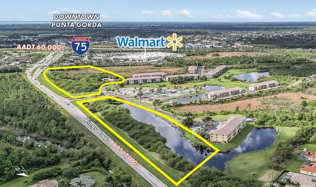
185 Kings Hwy, Punta Gorda, FL 33983
This Property Is For Sale
NEARBY LISTINGS FOR SALE OR LEASE
Property Detail
185 Kings Hwy
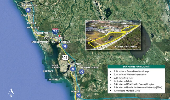
Southwest Florida
Eagle Point Golf Course Parcel 4
Punta Gorda, FL
06 40 23 P-1-9-2 4.39A M/L 21.72 A M/L COMM AT NE COR SEC 6 S ALG E SEC LN 320 FT FOR POB CONT SW AL SEC LN 263.13 FT TO NW R/W OF KINGS HWY SW ALG SAID R/W 1074.33FT NW 144.09FT NW ALG ARC OF A CURVE 117.31FT NE 504.45FT NE ALG ARC OF
402306276002
Charlotte
Commercialacreage
Florida
A
21
12015C0068G
10.37 AC
2024
Charlotte County
2025
DEMOGRAPHICS near 185 Kings Hwy
1 Mile
3 Mile
5 Mile
2024 Total Population
4,907
35,417
75,609
2029 Population
5,840
42,168
89,805
Pop Growth 2024-2029
+ 19.01%
+ 19.06%
+ 18.78%
Average Age
54
52
49
2024 Total Households
2,433
15,933
33,282
HH Growth 2024-2029
+ 19.40%
+ 19.44%
+ 19.16%
Median Household Inc
$63,571
$62,750
$55,096
Avg Household Size
2.00
2.20
2.20
2024 Avg HH Vehicles
2.00
2.00
2.00
Median Home Value
$250,000
$239,282
$222,483
Median Year Built
1997
1993
1987
Nearby Places
Map Layers
Map Styles
 Street
 Aerial
- Restaurants
- Banks
- Shops
- Fitness
- Groceries
PUBLIC TRANSPORTATION
AIRPORT
Punta Gorda
DRIVE
WALK
Distance
Punta Gorda
16 min
10.4 mi
Southwest Florida International
DRIVE
WALK
Distance
Southwest Florida International
52 min
43.1 mi
Freight Ports
Port Manatee
DRIVE
WALK
Distance
Port Manatee
77 min
64.8 mi
Nearby Properties
Address
Land Use
TOTAL SIZE
Lot Size
Zoning
Address
Land Use
TOTAL SIZE
Lot Size
Zoning
202,009 SF
20.89 AC
PD
Address
Land Use
TOTAL SIZE
Lot Size
Zoning
204,731 SF
16.11 AC
PD
Address
Land Use
TOTAL SIZE
Lot Size
Zoning
229,973 SF
21.33 AC
PD
Address
Land Use
TOTAL SIZE
Lot Size
Zoning
249,777 SF
48 AC
RMF10
Address
Land Use
TOTAL SIZE
Lot Size
Zoning
217,784 SF
38.63 AC
PD
Address
Land Use
TOTAL SIZE
Lot Size
Zoning
139,109 SF
23.44 AC
CG
Address
Land Use
TOTAL SIZE
Lot Size
Zoning
73,222 SF
5.14 AC
PD
Address
Land Use
TOTAL SIZE
Lot Size
Zoning
50,970 SF
9.74 AC
RSF3.5
Address
Land Use
TOTAL SIZE
Lot Size
Zoning
41,148 SF
155.85 AC
RSF-3
Address
Land Use
TOTAL SIZE
Lot Size
Zoning
83,180 SF
9.31 AC
PD
Address
Land Use
TOTAL SIZE
Lot Size
Zoning
95,547 SF
14.06 AC
PD
Address
Land Use
TOTAL SIZE
Lot Size
Zoning
35,951 SF
24.23 AC
PD
Address
Land Use
TOTAL SIZE
Lot Size
Zoning
27,082 SF
2.05 AC
PD
Address
Land Use
TOTAL SIZE
Lot Size
Zoning
84,500 SF
5.59 AC
CG
Address
Land Use
TOTAL SIZE
Lot Size
Zoning
86,773 SF
5.07 AC
IG
Address
Land Use
TOTAL SIZE
Lot Size
Zoning
23,798 SF
1.71 AC
PD
Address
Land Use
TOTAL SIZE
Lot Size
Zoning
98,552 SF
11.42 AC
CG
Address
Land Use
TOTAL SIZE
Lot Size
Zoning
82.27 AC
PD
Address
Land Use
TOTAL SIZE
Lot Size
Zoning
21.61 AC
PD
Address
Land Use
TOTAL SIZE
Lot Size
Zoning
81,226 SF
11.40 AC
OMI
Address
Land Use
TOTAL SIZE
Lot Size
Zoning
12,977 SF
2.29 AC
PD
Address
Land Use
TOTAL SIZE
Lot Size
Zoning
13,642 SF
2.55 AC
PD
Address
Land Use
TOTAL SIZE
Lot Size
Zoning
36,798 SF
19.40 AC
RSF3.5
Address
Land Use
TOTAL SIZE
Lot Size
Zoning
34,983 SF
18.79 AC
RE1
Address
Land Use
TOTAL SIZE
Lot Size
Zoning
11,773 SF
1.55 AC
PD
Address
Land Use
TOTAL SIZE
Lot Size
Zoning
7.81 AC
PD
Address
Land Use
TOTAL SIZE
Lot Size
Zoning
30,928 SF
41.30 AC
PKR
Address
Land Use
TOTAL SIZE
Lot Size
Zoning
73,260 SF
7.68 AC
PD
Address
Land Use
TOTAL SIZE
Lot Size
Zoning
74,434 SF
4.42 AC
CG
Address
Land Use
TOTAL SIZE
Lot Size
Zoning
23,566 SF
20.33 AC
RMF10
The World's #1 Commercial Real Estate Marketplace
Connect with us
© 2025 CoStar Group
The information above has been obtained from sources believed reliable. While we do not doubt its accuracy we have not verified it and make no guarantee, warranty or representation about it. It is your responsibility to independently confirm its accuracy and completeness. Any projections, opinions, assumptions, or estimates used are for example only and do not represent the current or future performance of the property. The value of this transaction to you depends on tax and other factors which should be evaluated by your tax, financial, and legal advisors. You and your advisors should conduct a careful, independent investigation of the property to determine to your satisfaction the suitability of the property for your needs.