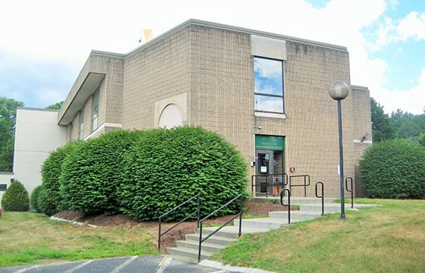
Property Record
185 Old Ferry Rd, Brattleboro, VT 05301


NEARBY LISTINGS FOR SALE OR LEASE
Property Detail
185 Old Ferry Rd
Officebuilding
BUILDING/LAND
X
Windham
50025C0393E
Vermont
0
2.06 AC
2024
Vermont South Area
968600
Other Market Areas
7,729 SF
081-025-15453
DEMOGRAPHICS near 185 Old Ferry Rd
1 Mile
3 Mile
5 Mile
2024 Total Population
319
4,121
15,886
2029 Population
324
4,172
15,975
Pop Growth 2024-2029
+ 1.57%
+ 1.24%
+ 0.56%
Average Age
46
46
45
2024 Total Households
135
1,898
7,473
HH Growth 2024-2029
+ 0.74%
+ 1.26%
+ 0.55%
Median Household Inc
$79,861
$63,378
$53,581
Avg Household Size
2.30
2.00
2.00
2024 Avg HH Vehicles
2.00
2.00
2.00
Median Home Value
$306,250
$312,847
$245,191
Median Year Built
1971
1964
1970
Nearby Places
Map Layers
Map Styles
 Street
 Aerial
- Restaurants
- Banks
- Shops
- Fitness
- Groceries
PUBLIC TRANSPORTATION
COMMUTER RAIL
Brattleboro Amtrak Station (Vermonter - Amtrak)
DRIVE
WALK
Distance
Brattleboro Amtrak Station (Vermonter - Amtrak)
10 min
3.7 mi
Freight Ports
Albany, NY Port
DRIVE
WALK
Distance
Albany, NY Port
136 min
84.4 mi
SALE & LEASE HISTORY
LISTING DATE
SALE/LEASE

Sep 23, 2016
For Sale
Nearby Properties
Address
Land Use
TOTAL SIZE
Lot Size
Zoning
Address
Land Use
TOTAL SIZE
Lot Size
Zoning
Address
Land Use
TOTAL SIZE
Lot Size
Zoning
63.75 AC
I / IN
Address
Land Use
TOTAL SIZE
Lot Size
Zoning
Address
Land Use
TOTAL SIZE
Lot Size
Zoning
Address
Land Use
TOTAL SIZE
Lot Size
Zoning
29,829 SF
31.93 AC
COMM/I
Address
Land Use
TOTAL SIZE
Lot Size
Zoning
25.40 AC
Address
Land Use
TOTAL SIZE
Lot Size
Zoning
15.56 AC
C / CO
Address
Land Use
TOTAL SIZE
Lot Size
Zoning
21,865 SF
0.96 AC
Address
Land Use
TOTAL SIZE
Lot Size
Zoning
135,935 SF
26.51 AC
N5 / N
Address
Land Use
TOTAL SIZE
Lot Size
Zoning
11.44 AC
C / CO
Address
Land Use
TOTAL SIZE
Lot Size
Zoning
5 AC
C / CO
Address
Land Use
TOTAL SIZE
Lot Size
Zoning
163,367 SF
39.52 AC
I / IN
Address
Land Use
TOTAL SIZE
Lot Size
Zoning
12,376 SF
1.51 AC
UC
Address
Land Use
TOTAL SIZE
Lot Size
Zoning
3.80 AC
Address
Land Use
TOTAL SIZE
Lot Size
Zoning
12.89 AC
NR
Address
Land Use
TOTAL SIZE
Lot Size
Zoning
1,276 SF
32.94 AC
RR
Address
Land Use
TOTAL SIZE
Lot Size
Zoning
0.87 AC
UC
Address
Land Use
TOTAL SIZE
Lot Size
Zoning
Address
Land Use
TOTAL SIZE
Lot Size
Zoning
15,471 SF
4.75 AC
C / CO
Address
Land Use
TOTAL SIZE
Lot Size
Zoning
11,436 SF
1.92 AC
C
Address
Land Use
TOTAL SIZE
Lot Size
Zoning
3.93 AC
C
Address
Land Use
TOTAL SIZE
Lot Size
Zoning
7,304 SF
3.40 AC
COMM/I
Address
Land Use
TOTAL SIZE
Lot Size
Zoning
35 AC
I / IN
Address
Land Use
TOTAL SIZE
Lot Size
Zoning
19.55 AC
I
Address
Land Use
TOTAL SIZE
Lot Size
Zoning
10,115 SF
0.68 AC
UC / U
Address
Land Use
TOTAL SIZE
Lot Size
Zoning
56,778 SF
24.33 AC
COMM/I
Address
Land Use
TOTAL SIZE
Lot Size
Zoning
7,188 SF
0.30 AC
UC
Address
Land Use
TOTAL SIZE
Lot Size
Zoning
571.10 AC
Address
Land Use
TOTAL SIZE
Lot Size
Zoning
7.39 AC
C
Address
Land Use
TOTAL SIZE
Lot Size
Zoning
14.13 AC
PU
The World's #1 Commercial Real Estate Marketplace
Connect with us
© 2026 CoStar Group
The information above has been obtained from sources believed reliable. While we do not doubt its accuracy we have not verified it and make no guarantee, warranty or representation about it. It is your responsibility to independently confirm its accuracy and completeness. Any projections, opinions, assumptions, or estimates used are for example only and do not represent the current or future performance of the property. The value of this transaction to you depends on tax and other factors which should be evaluated by your tax, financial, and legal advisors. You and your advisors should conduct a careful, independent investigation of the property to determine to your satisfaction the suitability of the property for your needs.