Property Record
185 Pine St, Raynham, MA 02767


Save to a Folder
{{folder.Name}}
{{folder.ListingIds.length}} Properties
{{folder.ListingIds.length}} Property
Create a New Folder
Property Detail
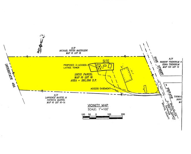
185 Pine St
RAYN-000010-000016
BRISTOL
Commercialbuilding
Massachusetts
B and X Area of moderate flood hazard, usually the area between the limits of the 100-year and 500-year floods.
6.55 AC
2025
Attleboro/New Bedford
2025
Boston
612202
Providence-Warwick, RI-MA
6,000 SF
NEARBY LISTINGS FOR SALE OR LEASE
DEMOGRAPHICS near 185 Pine St
1 mile
3 mile
5 mile
2025 Total Population
1,896
19,270
71,360
2030 Population
1,974
19,825
72,688
Pop Growth 2025-2030
+ 4.11%
+ 2.88%
+ 1.86%
Average Age
40
41
41
2025 Total Households
634
6,686
25,656
HH Growth 2025-2030
+ 4.10%
+ 2.93%
+ 1.90%
Median Household Inc
$148,557
$127,296
$95,136
Avg Household Size
3.00
2.80
2.50
2025 Avg HH Vehicles
3.00
2.00
2.00
Median Home Value
$697,916
$645,900
$497,326
Median Year Built
1997
1989
1975
Nearby Places
Map Layers
Map Styles
 Street
 Aerial
Layers
 Traffic
 Biking
Places
Listings with unknown addresses are not visible on the map
- Restaurants
- Banks
- Shops
- Fitness
- Groceries
PUBLIC TRANSPORTATION
COMMUTER RAIL
Bridgewater (Middleborough/Lakeville Line - Massachusetts Bay Transportation Authority Commuter Rail (Purple Line))
Drive
Walk
Distance
Bridgewater (Middleborough/Lakeville Line - Massachusetts Bay Transportation Authority Commuter Rail (Purple Line))
15 min
6.2 mi
Middleborough/Lakeville (Middleborough/Lakeville Line - Massachusetts Bay Transportation Authority Commuter Rail (Purple Line))
Drive
Walk
Distance
Middleborough/Lakeville (Middleborough/Lakeville Line - Massachusetts Bay Transportation Authority Commuter Rail (Purple Line))
16 min
8.2 mi
AIRPORT
Rhode Island Tf Green International
Drive
Walk
Distance
Rhode Island Tf Green International
57 min
31.1 mi
General Edward Lawrence Logan International
Drive
Walk
Distance
General Edward Lawrence Logan International
55 min
37.1 mi
Freight Ports
Port of New Bedford Harbor
Drive
Walk
Distance
Port of New Bedford Harbor
42 min
27.3 mi
Nearby Properties
Address
Land Use
TOTAL SIZE
Lot Size
Zoning
Address
Land Use
TOTAL SIZE
Lot Size
Zoning
0.78 AC
Address
Land Use
TOTAL SIZE
Lot Size
Zoning
24.34 AC
Address
Land Use
TOTAL SIZE
Lot Size
Zoning
815,324 SF
88.80 AC
Address
Land Use
TOTAL SIZE
Lot Size
Zoning
Address
Land Use
TOTAL SIZE
Lot Size
Zoning
87,591 SF
19.83 AC
Address
Land Use
TOTAL SIZE
Lot Size
Zoning
149,234 SF
40.69 AC
Address
Land Use
TOTAL SIZE
Lot Size
Zoning
219,000 SF
45.62 AC
Address
Land Use
TOTAL SIZE
Lot Size
Zoning
100,000 SF
24.80 AC
Address
Land Use
TOTAL SIZE
Lot Size
Zoning
104,207 SF
27.78 AC
Address
Land Use
TOTAL SIZE
Lot Size
Zoning
14.43 AC
Address
Land Use
TOTAL SIZE
Lot Size
Zoning
137,710 SF
26.66 AC
Address
Land Use
TOTAL SIZE
Lot Size
Zoning
206,139 SF
21.55 AC
Address
Land Use
TOTAL SIZE
Lot Size
Zoning
76,332 SF
6.20 AC
Address
Land Use
TOTAL SIZE
Lot Size
Zoning
133,773 SF
24.50 AC
Address
Land Use
TOTAL SIZE
Lot Size
Zoning
79,144 SF
5.30 AC
Address
Land Use
TOTAL SIZE
Lot Size
Zoning
90,920 SF
6.27 AC
Address
Land Use
TOTAL SIZE
Lot Size
Zoning
61,360 SF
5.10 AC
Address
Land Use
TOTAL SIZE
Lot Size
Zoning
16.06 AC
Address
Land Use
TOTAL SIZE
Lot Size
Zoning
76,111 SF
14.50 AC
Address
Land Use
TOTAL SIZE
Lot Size
Zoning
69,153 SF
4.47 AC
Address
Land Use
TOTAL SIZE
Lot Size
Zoning
112,770 SF
17.98 AC
Address
Land Use
TOTAL SIZE
Lot Size
Zoning
80,225 SF
8.07 AC
Address
Land Use
TOTAL SIZE
Lot Size
Zoning
51,664 SF
3.44 AC
Address
Land Use
TOTAL SIZE
Lot Size
Zoning
82,400 SF
19.12 AC
Address
Land Use
TOTAL SIZE
Lot Size
Zoning
528.28 AC
Address
Land Use
TOTAL SIZE
Lot Size
Zoning
56,384 SF
10.11 AC
Address
Land Use
TOTAL SIZE
Lot Size
Zoning
29.65 AC
Address
Land Use
TOTAL SIZE
Lot Size
Zoning
10.92 AC
Address
Land Use
TOTAL SIZE
Lot Size
Zoning
40,000 SF
9.27 AC
Address
Land Use
TOTAL SIZE
Lot Size
Zoning
56,354 SF
7.26 AC
The World's #1 Commercial Real Estate Marketplace
Connect with us
© 2026 CoStar Group
The information above has been obtained from sources believed reliable. While we do not doubt its accuracy we have not verified it and make no guarantee, warranty or representation about it. It is your responsibility to independently confirm its accuracy and completeness. Any projections, opinions, assumptions, or estimates used are for example only and do not represent the current or future performance of the property. The value of this transaction to you depends on tax and other factors which should be evaluated by your tax, financial, and legal advisors. You and your advisors should conduct a careful, independent investigation of the property to determine to your satisfaction the suitability of the property for your needs.