Property Record
185 Putnam Pike, Chepachet, RI 02814
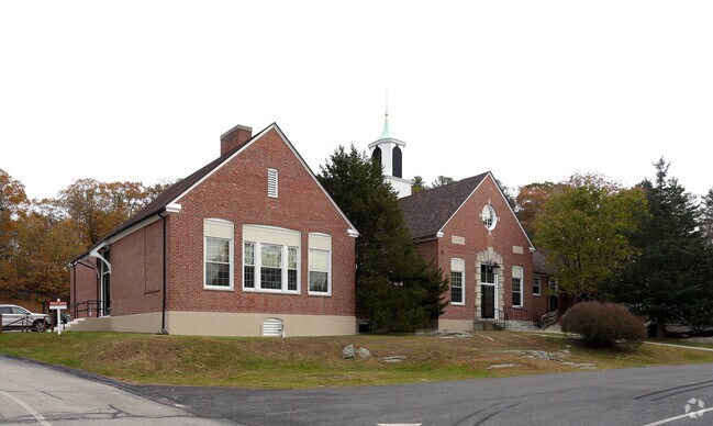

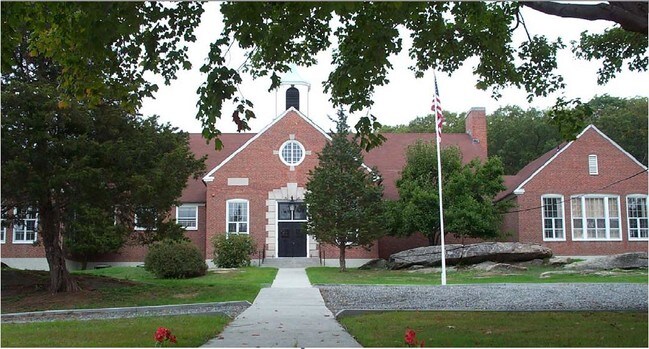
Property Detail
185 Putnam Pike
Commercialbuilding
Providence
20
Rhode Island
B and X Area of moderate flood hazard, usually the area between the limits of the 100-year and 500-year floods.
2.55 AC
2025
Burrillville/Glocester
2025
Providence
013102
Providence-Warwick, RI-MA
11,688 SF
GLOC-000017-000000-000082
NEARBY LISTINGS FOR SALE OR LEASE
-
-
View all Chepachet listings for sale on LoopNet.com
DEMOGRAPHICS near 185 Putnam Pike
1 mile
3 mile
5 mile
2025 Total Population
984
15,298
38,543
2030 Population
1,023
16,129
40,380
Pop Growth 2025-2030
+ 3.96%
+ 5.43%
+ 4.77%
Average Age
45
46
43
2025 Total Households
385
5,780
14,089
HH Growth 2025-2030
+ 3.64%
+ 5.59%
+ 5.00%
Median Household Inc
$131,653
$103,871
$105,726
Avg Household Size
2.50
2.50
2.50
2025 Avg HH Vehicles
3.00
2.00
2.00
Median Home Value
$424,576
$441,248
$434,698
Median Year Built
1958
1975
1973
Nearby Places
Map Layers
Map Styles
 Street
 Aerial
Layers
 Traffic
 Biking
Places
Listings with unknown addresses are not visible on the map
- Restaurants
- Banks
- Shops
- Fitness
- Groceries
PUBLIC TRANSPORTATION
AIRPORT
Rhode Island Tf Green International
Drive
Walk
Distance
Rhode Island Tf Green International
30 min
18.4 mi
Worcester Regional
Drive
Walk
Distance
Worcester Regional
59 min
40.7 mi
Freight Ports
Port of Davisville, RI
Drive
Walk
Distance
Port of Davisville, RI
41 min
27.7 mi
Nearby Properties
Address
Land Use
TOTAL SIZE
Lot Size
Zoning
Address
Land Use
TOTAL SIZE
Lot Size
Zoning
166,368 SF
10.74 AC
R20
Address
Land Use
TOTAL SIZE
Lot Size
Zoning
31.11 AC
R20M
Address
Land Use
TOTAL SIZE
Lot Size
Zoning
89,788 SF
11.25 AC
R20
Address
Land Use
TOTAL SIZE
Lot Size
Zoning
72,531 SF
11.70 AC
R20
Address
Land Use
TOTAL SIZE
Lot Size
Zoning
9.59 AC
MU
Address
Land Use
TOTAL SIZE
Lot Size
Zoning
87,649 SF
8 AC
R20
Address
Land Use
TOTAL SIZE
Lot Size
Zoning
85,130 SF
4.40 AC
R20
Address
Land Use
TOTAL SIZE
Lot Size
Zoning
45,899 SF
41.06 AC
20
Address
Land Use
TOTAL SIZE
Lot Size
Zoning
1 AC
PD
Address
Land Use
TOTAL SIZE
Lot Size
Zoning
60,658 SF
11.40 AC
MU
Address
Land Use
TOTAL SIZE
Lot Size
Zoning
45,183 SF
9.75 AC
R80
Address
Land Use
TOTAL SIZE
Lot Size
Zoning
173.57 AC
20
Address
Land Use
TOTAL SIZE
Lot Size
Zoning
30,275 SF
1.42 AC
MU
Address
Land Use
TOTAL SIZE
Lot Size
Zoning
1.81 AC
V
Address
Land Use
TOTAL SIZE
Lot Size
Zoning
36,973 SF
4.71 AC
R20
Address
Land Use
TOTAL SIZE
Lot Size
Zoning
2.37 AC
V
Address
Land Use
TOTAL SIZE
Lot Size
Zoning
17.99 AC
I
Address
Land Use
TOTAL SIZE
Lot Size
Zoning
53,824 SF
3.13 AC
V
Address
Land Use
TOTAL SIZE
Lot Size
Zoning
11,436 SF
95.42 AC
R20
Address
Land Use
TOTAL SIZE
Lot Size
Zoning
5.13 AC
V
Address
Land Use
TOTAL SIZE
Lot Size
Zoning
29,320 SF
0.52 AC
C
Address
Land Use
TOTAL SIZE
Lot Size
Zoning
1 AC
R80
Address
Land Use
TOTAL SIZE
Lot Size
Zoning
9,211 SF
7.64 AC
R20
Address
Land Use
TOTAL SIZE
Lot Size
Zoning
19,473 SF
52 AC
10
Address
Land Use
TOTAL SIZE
Lot Size
Zoning
11,446 SF
0.69 AC
MU
Address
Land Use
TOTAL SIZE
Lot Size
Zoning
3.47 AC
R80
Address
Land Use
TOTAL SIZE
Lot Size
Zoning
18,564 SF
4.27 AC
R20
Address
Land Use
TOTAL SIZE
Lot Size
Zoning
51.19 AC
10
Address
Land Use
TOTAL SIZE
Lot Size
Zoning
131.39 AC
20
Address
Land Use
TOTAL SIZE
Lot Size
Zoning
238.68 AC
20
The World's #1 Commercial Real Estate Marketplace
Connect with us
© 2026 CoStar Group
The information above has been obtained from sources believed reliable. While we do not doubt its accuracy we have not verified it and make no guarantee, warranty or representation about it. It is your responsibility to independently confirm its accuracy and completeness. Any projections, opinions, assumptions, or estimates used are for example only and do not represent the current or future performance of the property. The value of this transaction to you depends on tax and other factors which should be evaluated by your tax, financial, and legal advisors. You and your advisors should conduct a careful, independent investigation of the property to determine to your satisfaction the suitability of the property for your needs.