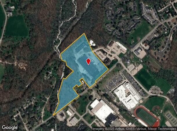
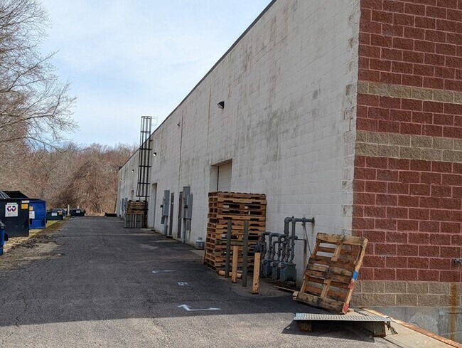
Property Record
185 S Broad St, Pawcatuck, CT 06379

NEARBY LISTINGS FOR SALE OR LEASE
Property Detail
185 S Broad St
STON-000037-000001-000004
New London
Commercialnec
Connecticut
AE
4
09011C0551J
16.53 AC
2025
SE New London
2025
Hartford
705102
Norwich-New London, CT
DEMOGRAPHICS near 185 S Broad St
1 Mile
3 Mile
5 Mile
2024 Total Population
1,727
21,982
36,642
2029 Population
1,733
21,704
36,768
Pop Growth 2024-2029
+ 0.35%
(1.26%)
+ 0.34%
Average Age
46
45
47
2024 Total Households
817
9,804
16,260
HH Growth 2024-2029
0.00%
(1.46%)
+ 0.30%
Median Household Inc
$58,599
$76,351
$88,704
Avg Household Size
2.10
2.20
2.20
2024 Avg HH Vehicles
2.00
2.00
2.00
Median Home Value
$352,868
$365,963
$398,514
Median Year Built
1980
1965
1968
Nearby Places
Map Layers
Map Styles
 Street
 Aerial
- Restaurants
- Banks
- Shops
- Fitness
- Groceries
PUBLIC TRANSPORTATION
COMMUTER RAIL
DRIVE
WALK
Distance
6 min
2.6 mi
DRIVE
WALK
Distance
11 min
6.4 mi
AIRPORT
Rhode Island Tf Green International
DRIVE
WALK
Distance
Rhode Island Tf Green International
56 min
40.4 mi
Freight Ports
Port of Davisville, RI
DRIVE
WALK
Distance
Port of Davisville, RI
58 min
40.6 mi
SALE & LEASE HISTORY
LISTING DATE
SALE/LEASE

Oct 20, 2020
For Lease
Dec 17, 2023
For Lease
Nearby Properties
Address
Land Use
TOTAL SIZE
Lot Size
Zoning
Address
Land Use
TOTAL SIZE
Lot Size
Zoning
10.60 AC
Address
Land Use
TOTAL SIZE
Lot Size
Zoning
181,967 SF
143 AC
RR-80
Address
Land Use
TOTAL SIZE
Lot Size
Zoning
154,316 SF
4.57 AC
Address
Land Use
TOTAL SIZE
Lot Size
Zoning
25.60 AC
Address
Land Use
TOTAL SIZE
Lot Size
Zoning
14.24 AC
Address
Land Use
TOTAL SIZE
Lot Size
Zoning
17,993 SF
13.03 AC
Address
Land Use
TOTAL SIZE
Lot Size
Zoning
96,882 SF
13.12 AC
Address
Land Use
TOTAL SIZE
Lot Size
Zoning
14.71 AC
Address
Land Use
TOTAL SIZE
Lot Size
Zoning
14.04 AC
Address
Land Use
TOTAL SIZE
Lot Size
Zoning
66,003 SF
44.50 AC
GBR-13
Address
Land Use
TOTAL SIZE
Lot Size
Zoning
117,852 SF
19.78 AC
Address
Land Use
TOTAL SIZE
Lot Size
Zoning
0.55 AC
Address
Land Use
TOTAL SIZE
Lot Size
Zoning
40.80 AC
M-1
Address
Land Use
TOTAL SIZE
Lot Size
Zoning
7.79 AC
Address
Land Use
TOTAL SIZE
Lot Size
Zoning
5,055 SF
24.56 AC
GBR-13
Address
Land Use
TOTAL SIZE
Lot Size
Zoning
40,943 SF
25.78 AC
Address
Land Use
TOTAL SIZE
Lot Size
Zoning
32.01 AC
M-1
Address
Land Use
TOTAL SIZE
Lot Size
Zoning
40,705 SF
1.07 AC
Address
Land Use
TOTAL SIZE
Lot Size
Zoning
64,166 SF
12 AC
HI-60
Address
Land Use
TOTAL SIZE
Lot Size
Zoning
47,737 SF
9.96 AC
Address
Land Use
TOTAL SIZE
Lot Size
Zoning
60,968 SF
8 AC
RA-15
Address
Land Use
TOTAL SIZE
Lot Size
Zoning
25.88 AC
RR-80
Address
Land Use
TOTAL SIZE
Lot Size
Zoning
121,068 SF
2.53 AC
M-1
Address
Land Use
TOTAL SIZE
Lot Size
Zoning
46,362 SF
7.43 AC
Address
Land Use
TOTAL SIZE
Lot Size
Zoning
114.16 AC
OS
Address
Land Use
TOTAL SIZE
Lot Size
Zoning
3,000 SF
50.36 AC
HI-60
Address
Land Use
TOTAL SIZE
Lot Size
Zoning
15.58 AC
Address
Land Use
TOTAL SIZE
Lot Size
Zoning
31,288 SF
2.30 AC
Address
Land Use
TOTAL SIZE
Lot Size
Zoning
0.81 AC
The World's #1 Commercial Real Estate Marketplace
Connect with us
© 2025 CoStar Group
The information above has been obtained from sources believed reliable. While we do not doubt its accuracy we have not verified it and make no guarantee, warranty or representation about it. It is your responsibility to independently confirm its accuracy and completeness. Any projections, opinions, assumptions, or estimates used are for example only and do not represent the current or future performance of the property. The value of this transaction to you depends on tax and other factors which should be evaluated by your tax, financial, and legal advisors. You and your advisors should conduct a careful, independent investigation of the property to determine to your satisfaction the suitability of the property for your needs.