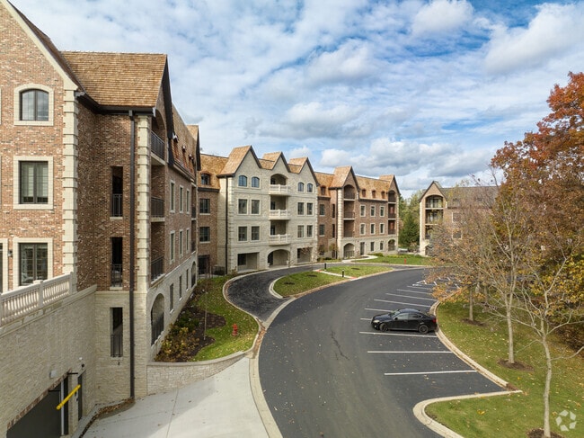
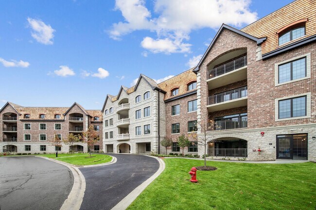
Property Record
1850 Amberley Ct, Lake Forest, IL 60045
NEARBY LISTINGS FOR SALE OR LEASE
-
-
View all Lake Forest listings for sale on LoopNet.com
Property Detail
1850 Amberley Ct
Chicago-Naperville-Elgin, IL-IN-WI
Amberley Woods Sub
15-01-205-042
AMBERLEY WOODS SUB;PT LOT 26 DAFS,BEG SWCOR,NE 32.95,NE AL G CUV 271.94,N72.86,NW 137.48,N 226.45,W 183.62,S TO PO B
Commercialbuilding
Lake
X
Illinois
17097C0257K
26
2023
2.08 AC
2024
Southeast Lake County
866200
Chicago
DEMOGRAPHICS near 1850 Amberley Ct
1 Mile
3 Mile
5 Mile
2024 Total Population
1,785
21,326
119,656
2029 Population
1,802
21,378
119,335
Pop Growth 2024-2029
+ 0.95%
+ 0.24%
(0.27%)
Average Age
48
46
41
2024 Total Households
642
8,046
44,282
HH Growth 2024-2029
+ 0.93%
+ 0.24%
(0.25%)
Median Household Inc
$195,369
$168,664
$130,420
Avg Household Size
2.60
2.50
2.60
2024 Avg HH Vehicles
2.00
2.00
2.00
Median Home Value
$814,049
$753,555
$539,730
Median Year Built
1991
1983
1981
Nearby Places
Map Layers
Map Styles
 Street
 Aerial
- Restaurants
- Banks
- Shops
- Fitness
- Groceries
PUBLIC TRANSPORTATION
COMMUTER RAIL
Lake Forest Station (Md-North) (Milwaukee District North Line - Northeast Illinois Regional Commuter Railroad (Metra))
DRIVE
WALK
Distance
Lake Forest Station (Md-North) (Milwaukee District North Line - Northeast Illinois Regional Commuter Railroad (Metra))
5 min
2.7 mi
Lake Forest Station (Up-North) (Union Pacific North Line - Northeast Illinois Regional Commuter Railroad (Metra))
DRIVE
WALK
Distance
Lake Forest Station (Up-North) (Union Pacific North Line - Northeast Illinois Regional Commuter Railroad (Metra))
8 min
3.5 mi
AIRPORT
Chicago O'Hare International
DRIVE
WALK
Distance
Chicago O'Hare International
30 min
21.7 mi
Freight Ports
Port Milwaukee
DRIVE
WALK
Distance
Port Milwaukee
67 min
56.7 mi
Nearby Properties
Address
Land Use
TOTAL SIZE
Lot Size
Zoning
Address
Land Use
TOTAL SIZE
Lot Size
Zoning
145.94 AC
Address
Land Use
TOTAL SIZE
Lot Size
Zoning
12.96 AC
Address
Land Use
TOTAL SIZE
Lot Size
Zoning
19.93 AC
Address
Land Use
TOTAL SIZE
Lot Size
Zoning
23.12 AC
Address
Land Use
TOTAL SIZE
Lot Size
Zoning
Address
Land Use
TOTAL SIZE
Lot Size
Zoning
Address
Land Use
TOTAL SIZE
Lot Size
Zoning
51,750 SF
48.98 AC
Address
Land Use
TOTAL SIZE
Lot Size
Zoning
17.35 AC
Address
Land Use
TOTAL SIZE
Lot Size
Zoning
253,218 SF
2.88 AC
Address
Land Use
TOTAL SIZE
Lot Size
Zoning
Address
Land Use
TOTAL SIZE
Lot Size
Zoning
7.98 AC
Address
Land Use
TOTAL SIZE
Lot Size
Zoning
Address
Land Use
TOTAL SIZE
Lot Size
Zoning
10.24 AC
Address
Land Use
TOTAL SIZE
Lot Size
Zoning
70,404 SF
0.65 AC
Address
Land Use
TOTAL SIZE
Lot Size
Zoning
Address
Land Use
TOTAL SIZE
Lot Size
Zoning
25.66 AC
Address
Land Use
TOTAL SIZE
Lot Size
Zoning
698,127 SF
7.94 AC
Address
Land Use
TOTAL SIZE
Lot Size
Zoning
Address
Land Use
TOTAL SIZE
Lot Size
Zoning
10.68 AC
Address
Land Use
TOTAL SIZE
Lot Size
Zoning
10.80 AC
Address
Land Use
TOTAL SIZE
Lot Size
Zoning
15.47 AC
Address
Land Use
TOTAL SIZE
Lot Size
Zoning
16.06 AC
Address
Land Use
TOTAL SIZE
Lot Size
Zoning
7.99 AC
Address
Land Use
TOTAL SIZE
Lot Size
Zoning
15.23 AC
Address
Land Use
TOTAL SIZE
Lot Size
Zoning
15.18 AC
Address
Land Use
TOTAL SIZE
Lot Size
Zoning
3.57 AC
Address
Land Use
TOTAL SIZE
Lot Size
Zoning
74,599 SF
9.16 AC
Address
Land Use
TOTAL SIZE
Lot Size
Zoning
8.81 AC
Address
Land Use
TOTAL SIZE
Lot Size
Zoning
68,100 SF
1.28 AC
Address
Land Use
TOTAL SIZE
Lot Size
Zoning
The World's #1 Commercial Real Estate Marketplace
Connect with us
© 2025 CoStar Group
The information above has been obtained from sources believed reliable. While we do not doubt its accuracy we have not verified it and make no guarantee, warranty or representation about it. It is your responsibility to independently confirm its accuracy and completeness. Any projections, opinions, assumptions, or estimates used are for example only and do not represent the current or future performance of the property. The value of this transaction to you depends on tax and other factors which should be evaluated by your tax, financial, and legal advisors. You and your advisors should conduct a careful, independent investigation of the property to determine to your satisfaction the suitability of the property for your needs.