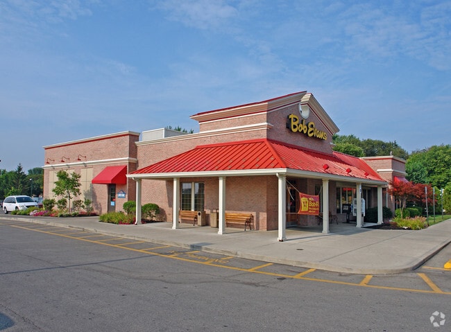
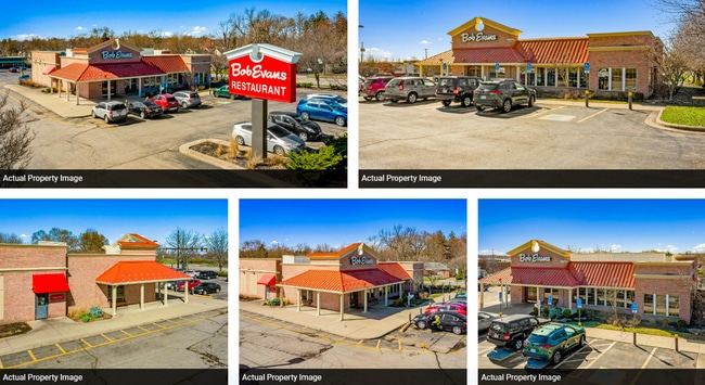
Property Record
1850 E Dorothy Ln, Dayton, OH 45429


NEARBY LISTINGS FOR SALE OR LEASE
Property Detail
1850 E Dorothy Ln
N64-03405-0163
6-2-23
Restaurantdrivein
Montgomery
X
Ohio
39113C0259F
163
2024
1 AC
2025
South Central Dayton
021501
Cincinnati/Dayton
5,417 SF
Dayton, OH
DEMOGRAPHICS near 1850 E Dorothy Ln
1 Mile
3 Mile
5 Mile
2024 Total Population
10,915
88,713
209,694
2029 Population
10,741
87,715
209,340
Pop Growth 2024-2029
(1.59%)
(1.12%)
(0.17%)
Average Age
39
41
40
2024 Total Households
4,785
40,188
88,415
HH Growth 2024-2029
(1.65%)
(1.14%)
(0.23%)
Median Household Inc
$63,004
$66,958
$65,810
Avg Household Size
2.20
2.10
2.20
2024 Avg HH Vehicles
2.00
2.00
2.00
Median Home Value
$144,247
$171,380
$178,353
Median Year Built
1958
1958
1960
Nearby Places
Map Layers
Map Styles
 Street
 Aerial
- Restaurants
- Banks
- Shops
- Fitness
- Groceries
PUBLIC TRANSPORTATION
AIRPORT
James M Cox Dayton International
DRIVE
WALK
Distance
James M Cox Dayton International
31 min
21.9 mi
Freight Ports
Virginia Port Authority - Richmond
DRIVE
WALK
Distance
Virginia Port Authority - Richmond
1 min
394.1 mi
SALE & LEASE HISTORY
LISTING DATE
SALE/LEASE

Jul 27, 2023
For Sale
Apr 22, 2025
For Sale
Nearby Properties
Address
Land Use
TOTAL SIZE
Lot Size
Zoning
Address
Land Use
TOTAL SIZE
Lot Size
Zoning
414,094 SF
36.48 AC
Address
Land Use
TOTAL SIZE
Lot Size
Zoning
275,808 SF
19.97 AC
Address
Land Use
TOTAL SIZE
Lot Size
Zoning
55.88 AC
Address
Land Use
TOTAL SIZE
Lot Size
Zoning
752,874 SF
74.85 AC
Address
Land Use
TOTAL SIZE
Lot Size
Zoning
175,938 SF
49.33 AC
Address
Land Use
TOTAL SIZE
Lot Size
Zoning
53.48 AC
RP1
Address
Land Use
TOTAL SIZE
Lot Size
Zoning
1,951 SF
56.54 AC
Address
Land Use
TOTAL SIZE
Lot Size
Zoning
240,090 SF
1.93 AC
MXPUD02
Address
Land Use
TOTAL SIZE
Lot Size
Zoning
Address
Land Use
TOTAL SIZE
Lot Size
Zoning
41.38 AC
Address
Land Use
TOTAL SIZE
Lot Size
Zoning
18.33 AC
Address
Land Use
TOTAL SIZE
Lot Size
Zoning
38,832 SF
30.51 AC
R-PUD 03-7
Address
Land Use
TOTAL SIZE
Lot Size
Zoning
1,008 SF
7 AC
R1A
Address
Land Use
TOTAL SIZE
Lot Size
Zoning
4.98 AC
Address
Land Use
TOTAL SIZE
Lot Size
Zoning
109,680 SF
32.24 AC
R4
Address
Land Use
TOTAL SIZE
Lot Size
Zoning
5.95 AC
Address
Land Use
TOTAL SIZE
Lot Size
Zoning
130,766 SF
1.68 AC
Address
Land Use
TOTAL SIZE
Lot Size
Zoning
152,844 SF
14.80 AC
Address
Land Use
TOTAL SIZE
Lot Size
Zoning
301,146 SF
19.40 AC
Address
Land Use
TOTAL SIZE
Lot Size
Zoning
89,176 SF
17.52 AC
Address
Land Use
TOTAL SIZE
Lot Size
Zoning
100,450 SF
1.66 AC
MXPUD02
Address
Land Use
TOTAL SIZE
Lot Size
Zoning
148,309 SF
1.50 AC
MXPUD02
Address
Land Use
TOTAL SIZE
Lot Size
Zoning
24.77 AC
Address
Land Use
TOTAL SIZE
Lot Size
Zoning
236,103 SF
7.28 AC
Address
Land Use
TOTAL SIZE
Lot Size
Zoning
309,331 SF
36 AC
Address
Land Use
TOTAL SIZE
Lot Size
Zoning
256,686 SF
11.05 AC
Address
Land Use
TOTAL SIZE
Lot Size
Zoning
20,144 SF
76.94 AC
A1
Address
Land Use
TOTAL SIZE
Lot Size
Zoning
278,085 SF
7.98 AC
Address
Land Use
TOTAL SIZE
Lot Size
Zoning
54,604 SF
6.29 AC
MXPUD02
Address
Land Use
TOTAL SIZE
Lot Size
Zoning
205,801 SF
37.77 AC
The World's #1 Commercial Real Estate Marketplace
Connect with us
© 2026 CoStar Group
The information above has been obtained from sources believed reliable. While we do not doubt its accuracy we have not verified it and make no guarantee, warranty or representation about it. It is your responsibility to independently confirm its accuracy and completeness. Any projections, opinions, assumptions, or estimates used are for example only and do not represent the current or future performance of the property. The value of this transaction to you depends on tax and other factors which should be evaluated by your tax, financial, and legal advisors. You and your advisors should conduct a careful, independent investigation of the property to determine to your satisfaction the suitability of the property for your needs.