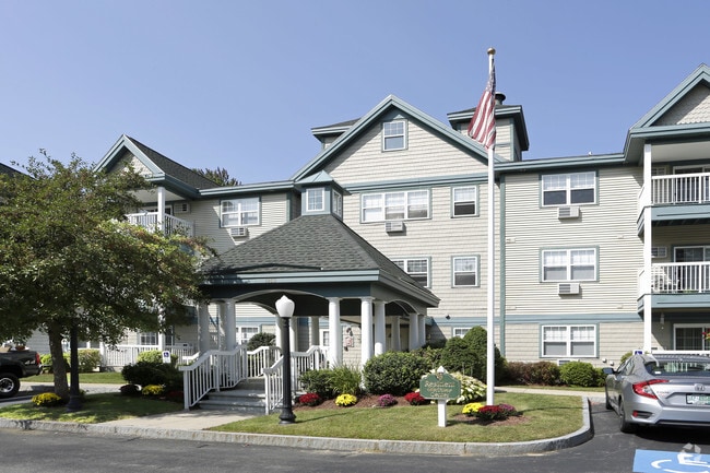
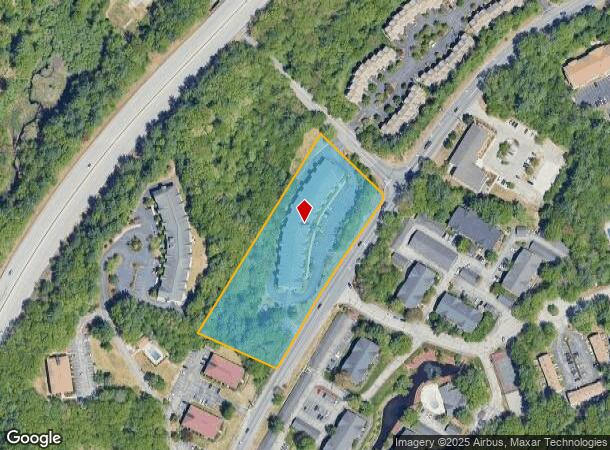
Property Record
1850 Front St, Manchester, NH 03102
NEARBY LISTINGS FOR SALE OR LEASE
Property Detail
1850 Front St
MNCH-000767-000000-000007
Hillsborough
Apartment
New Hampshire
X
7
33013C0686E
3.56 AC
2024
Northwest Manchester
2024
Boston
000203
Manchester-Nashua, NH
73,460 SF
DEMOGRAPHICS near 1850 Front St
1 Mile
3 Mile
5 Mile
2024 Total Population
6,129
45,712
124,499
2029 Population
6,295
46,812
126,871
Pop Growth 2024-2029
+ 2.71%
+ 2.41%
+ 1.91%
Average Age
41
41
40
2024 Total Households
2,940
19,482
51,523
HH Growth 2024-2029
+ 3.03%
+ 2.54%
+ 1.96%
Median Household Inc
$74,307
$79,224
$73,887
Avg Household Size
1.90
2.20
2.20
2024 Avg HH Vehicles
2.00
2.00
2.00
Median Home Value
$330,570
$341,150
$319,284
Median Year Built
1987
1976
1969
Nearby Places
Map Layers
Map Styles
 Street
 Aerial
- Restaurants
- Banks
- Shops
- Fitness
- Groceries
PUBLIC TRANSPORTATION
AIRPORT
Manchester Boston Regional
DRIVE
WALK
Distance
Manchester Boston Regional
22 min
10.3 mi
Portsmouth International at Pease
DRIVE
WALK
Distance
Portsmouth International at Pease
64 min
44.2 mi
Freight Ports
Port of Boston
DRIVE
WALK
Distance
Port of Boston
89 min
60.5 mi
Nearby Properties
Address
Land Use
TOTAL SIZE
Lot Size
Zoning
Address
Land Use
TOTAL SIZE
Lot Size
Zoning
58,227 SF
66.52 AC
Address
Land Use
TOTAL SIZE
Lot Size
Zoning
26,232 SF
39.97 AC
Address
Land Use
TOTAL SIZE
Lot Size
Zoning
12.60 AC
PZ
Address
Land Use
TOTAL SIZE
Lot Size
Zoning
135,686 SF
30.23 AC
Address
Land Use
TOTAL SIZE
Lot Size
Zoning
36,070 SF
141.66 AC
MUD4
Address
Land Use
TOTAL SIZE
Lot Size
Zoning
250,905 SF
1.16 AC
Address
Land Use
TOTAL SIZE
Lot Size
Zoning
8,064 SF
33.49 AC
Address
Land Use
TOTAL SIZE
Lot Size
Zoning
26,125 SF
150.66 AC
Address
Land Use
TOTAL SIZE
Lot Size
Zoning
143,630 SF
57.86 AC
Address
Land Use
TOTAL SIZE
Lot Size
Zoning
16,464 SF
15.19 AC
Address
Land Use
TOTAL SIZE
Lot Size
Zoning
16,000 SF
58.17 AC
Address
Land Use
TOTAL SIZE
Lot Size
Zoning
51.32 AC
MUD4
Address
Land Use
TOTAL SIZE
Lot Size
Zoning
154,363 SF
17.25 AC
MUD3
Address
Land Use
TOTAL SIZE
Lot Size
Zoning
264,671 SF
4.04 AC
Address
Land Use
TOTAL SIZE
Lot Size
Zoning
206,478 SF
3.91 AC
Address
Land Use
TOTAL SIZE
Lot Size
Zoning
44,301 SF
71.24 AC
Address
Land Use
TOTAL SIZE
Lot Size
Zoning
224,859 SF
17.70 AC
Address
Land Use
TOTAL SIZE
Lot Size
Zoning
8,530 SF
26.33 AC
Address
Land Use
TOTAL SIZE
Lot Size
Zoning
Address
Land Use
TOTAL SIZE
Lot Size
Zoning
27,450 SF
9.10 AC
Address
Land Use
TOTAL SIZE
Lot Size
Zoning
72,932 SF
44.26 AC
Address
Land Use
TOTAL SIZE
Lot Size
Zoning
367,086 SF
3.65 AC
Address
Land Use
TOTAL SIZE
Lot Size
Zoning
41,252 SF
6.87 AC
Address
Land Use
TOTAL SIZE
Lot Size
Zoning
107,144 SF
8.75 AC
Address
Land Use
TOTAL SIZE
Lot Size
Zoning
82,670 SF
27.76 AC
PZ
Address
Land Use
TOTAL SIZE
Lot Size
Zoning
5,150 SF
13.50 AC
Address
Land Use
TOTAL SIZE
Lot Size
Zoning
1,621 SF
8.24 AC
Address
Land Use
TOTAL SIZE
Lot Size
Zoning
146,177 SF
1.35 AC
Address
Land Use
TOTAL SIZE
Lot Size
Zoning
69,339 SF
39.63 AC
IND
Address
Land Use
TOTAL SIZE
Lot Size
Zoning
96,192 SF
17.42 AC
IND
The World's #1 Commercial Real Estate Marketplace
Connect with us
© 2025 CoStar Group
The information above has been obtained from sources believed reliable. While we do not doubt its accuracy we have not verified it and make no guarantee, warranty or representation about it. It is your responsibility to independently confirm its accuracy and completeness. Any projections, opinions, assumptions, or estimates used are for example only and do not represent the current or future performance of the property. The value of this transaction to you depends on tax and other factors which should be evaluated by your tax, financial, and legal advisors. You and your advisors should conduct a careful, independent investigation of the property to determine to your satisfaction the suitability of the property for your needs.