Property Record
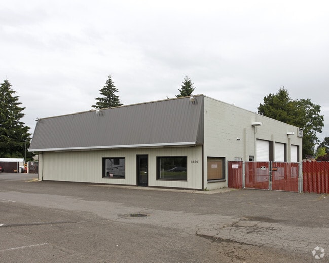
1850 N Adair St, Cornelius, OR 97113


Save to a Folder
{{folder.Name}}
{{folder.ListingIds.length}} Properties
{{folder.ListingIds.length}} Property
Create a New Folder
Property Detail
1850 N Adair St
R0755374
ACRES 0.73
Commercialbuilding
WASHINGTON
CC
Oregon
B and X Area of moderate flood hazard, usually the area between the limits of the 100-year and 500-year floods.
0.73 AC
2024
Westside Outlying
2026
Portland
032901
Portland-Vancouver-Hillsboro, OR-WA
4,632 SF
NEARBY LISTINGS FOR SALE OR LEASE
DEMOGRAPHICS near 1850 N Adair St
1 mile
3 mile
5 mile
2025 Total Population
13,137
37,204
92,697
2030 Population
13,619
38,311
94,315
Pop Growth 2025-2030
+ 3.67%
+ 2.98%
+ 1.75%
Average Age
38
38
39
2025 Total Households
3,881
12,158
30,708
HH Growth 2025-2030
+ 3.81%
+ 3.00%
+ 1.78%
Median Household Inc
$93,736
$87,959
$96,491
Avg Household Size
3.30
2.90
2.90
2025 Avg HH Vehicles
2.00
2.00
2.00
Median Home Value
$434,061
$456,139
$492,796
Median Year Built
1988
1984
1984
Nearby Places
Map Layers
Map Styles
 Street
 Aerial
Layers
 Traffic
 Biking
Places
Listings with unknown addresses are not visible on the map
- Restaurants
- Banks
- Shops
- Fitness
- Groceries
PUBLIC TRANSPORTATION
AIRPORT
Portland International
Drive
Walk
Distance
Portland International
56 min
36.5 mi
Freight Ports
Port of Portland
Drive
Walk
Distance
Port of Portland
39 min
25.6 mi
SALE & LEASE HISTORY
LISTING DATE
SALE/LEASE

Jun 22, 2022
For Sale
Nearby Properties
Address
Land Use
TOTAL SIZE
Lot Size
Zoning
Address
Land Use
TOTAL SIZE
Lot Size
Zoning
9.97 AC
SCC-DT
Address
Land Use
TOTAL SIZE
Lot Size
Zoning
608,403 SF
30.03 AC
RMH
Address
Land Use
TOTAL SIZE
Lot Size
Zoning
79,574 SF
16.54 AC
GI
Address
Land Use
TOTAL SIZE
Lot Size
Zoning
252,251 SF
2.62 AC
SCC-DT
Address
Land Use
TOTAL SIZE
Lot Size
Zoning
13.80 AC
GI
Address
Land Use
TOTAL SIZE
Lot Size
Zoning
108.84 AC
GI
Address
Land Use
TOTAL SIZE
Lot Size
Zoning
154,371 SF
15.63 AC
C2
Address
Land Use
TOTAL SIZE
Lot Size
Zoning
1.22 AC
I-G
Address
Land Use
TOTAL SIZE
Lot Size
Zoning
20.62 AC
I-G
Address
Land Use
TOTAL SIZE
Lot Size
Zoning
37,000 SF
29.09 AC
INST
Address
Land Use
TOTAL SIZE
Lot Size
Zoning
169,980 SF
14 AC
GMU
Address
Land Use
TOTAL SIZE
Lot Size
Zoning
2.83 AC
GMU
Address
Land Use
TOTAL SIZE
Lot Size
Zoning
65,500 SF
9.67 AC
R7
Address
Land Use
TOTAL SIZE
Lot Size
Zoning
86,022 SF
0.09 AC
SCC-DT
Address
Land Use
TOTAL SIZE
Lot Size
Zoning
0.05 AC
LI
Address
Land Use
TOTAL SIZE
Lot Size
Zoning
20.48 AC
LI
Address
Land Use
TOTAL SIZE
Lot Size
Zoning
222,852 SF
11.17 AC
RMH
Address
Land Use
TOTAL SIZE
Lot Size
Zoning
61,520 SF
2.02 AC
RMH
Address
Land Use
TOTAL SIZE
Lot Size
Zoning
72,365 SF
11.25 AC
R7
Address
Land Use
TOTAL SIZE
Lot Size
Zoning
102,902 SF
6.19 AC
I-G
Address
Land Use
TOTAL SIZE
Lot Size
Zoning
46,000 SF
7.68 AC
INST
Address
Land Use
TOTAL SIZE
Lot Size
Zoning
137,200 SF
9.52 AC
INST
Address
Land Use
TOTAL SIZE
Lot Size
Zoning
59,902 SF
1.40 AC
RMH
Address
Land Use
TOTAL SIZE
Lot Size
Zoning
32,187 SF
9.19 AC
AF-5
Address
Land Use
TOTAL SIZE
Lot Size
Zoning
9.53 AC
SFR-7
Address
Land Use
TOTAL SIZE
Lot Size
Zoning
98,100 SF
1.70 AC
SCC-DT
Address
Land Use
TOTAL SIZE
Lot Size
Zoning
176,108 SF
0.44 AC
CC
Address
Land Use
TOTAL SIZE
Lot Size
Zoning
199,045 SF
0.16 AC
SCC-DT
Address
Land Use
TOTAL SIZE
Lot Size
Zoning
7.35 AC
Address
Land Use
TOTAL SIZE
Lot Size
Zoning
The World's #1 Commercial Real Estate Marketplace
Connect with us
© 2026 CoStar Group
The information above has been obtained from sources believed reliable. While we do not doubt its accuracy we have not verified it and make no guarantee, warranty or representation about it. It is your responsibility to independently confirm its accuracy and completeness. Any projections, opinions, assumptions, or estimates used are for example only and do not represent the current or future performance of the property. The value of this transaction to you depends on tax and other factors which should be evaluated by your tax, financial, and legal advisors. You and your advisors should conduct a careful, independent investigation of the property to determine to your satisfaction the suitability of the property for your needs.