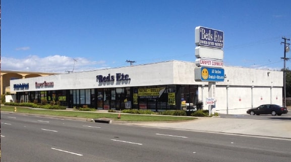
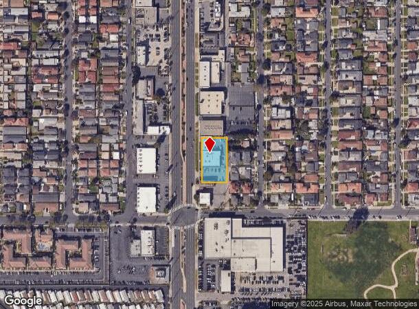
Property Record
18506 Hawthorne Blvd, Torrance, CA 90504

Current Lease Availabilities
NEARBY LISTINGS FOR SALE OR LEASE
Property Detail
18506 Hawthorne Blvd
Los Angeles-Long Beach-Glendale, CA
15933
4084-023-034
LOTS 138 AND 139 TR NO 15933 AND W 140 FT (EX OF ST) OF LOT 18 TR NO 10216
Storemultistory
Los Angeles
X
California
06037C1930F
138,1
2024
0.58 AC
2025
Torrance
650300
Los Angeles
10,185 SF
DEMOGRAPHICS near 18506 Hawthorne Blvd
1 Mile
3 Mile
5 Mile
2024 Total Population
23,830
257,646
567,226
2029 Population
23,117
250,535
551,220
Pop Growth 2024-2029
(2.99%)
(2.76%)
(2.82%)
Average Age
41
41
41
2024 Total Households
8,672
96,860
205,451
HH Growth 2024-2029
(3.25%)
(2.95%)
(3.00%)
Median Household Inc
$103,919
$104,736
$95,243
Avg Household Size
2.70
2.60
2.70
2024 Avg HH Vehicles
2.00
2.00
2.00
Median Home Value
$822,793
$912,555
$873,141
Median Year Built
1961
1965
1965
Nearby Places
- Restaurants
- Banks
- Shops
- Fitness
- Groceries
PUBLIC TRANSPORTATION
AIRPORT
Los Angeles International
DRIVE
WALK
Distance
Los Angeles International
15 min
9.0 mi
Long Beach (Daugherty Field)
DRIVE
WALK
Distance
Long Beach (Daugherty Field)
19 min
13.5 mi
Bob Hope
DRIVE
WALK
Distance
Bob Hope
44 min
32.6 mi
Freight Ports
Port of Long Beach
DRIVE
WALK
Distance
Port of Long Beach
22 min
15.4 mi
Nearby Properties
Address
Land Use
TOTAL SIZE
Lot Size
Zoning
Address
Land Use
TOTAL SIZE
Lot Size
Zoning
997,143 SF
98.35 AC
TOMI-BP
Address
Land Use
TOTAL SIZE
Lot Size
Zoning
267,305 SF
1.59 AC
TOHC-CTR
Address
Land Use
TOTAL SIZE
Lot Size
Zoning
205,797 SF
4.10 AC
HBR3*
Address
Land Use
TOTAL SIZE
Lot Size
Zoning
10,152 SF
140.14 AC
TOMI-HVY
Address
Land Use
TOTAL SIZE
Lot Size
Zoning
267,131 SF
12.10 AC
TOHHM
Address
Land Use
TOTAL SIZE
Lot Size
Zoning
718,086 SF
41.24 AC
RBI-1A
Address
Land Use
TOTAL SIZE
Lot Size
Zoning
848,217 SF
36.09 AC
RBI-1A
Address
Land Use
TOTAL SIZE
Lot Size
Zoning
321,011 SF
15.06 AC
TOMI-LT
Address
Land Use
TOTAL SIZE
Lot Size
Zoning
297,420 SF
6.65 AC
TOHC-CTR
Address
Land Use
TOTAL SIZE
Lot Size
Zoning
173,186 SF
2.07 AC
HBR3*
Address
Land Use
TOTAL SIZE
Lot Size
Zoning
604,106 SF
42.72 AC
TOMI-HVY
Address
Land Use
TOTAL SIZE
Lot Size
Zoning
1,504,661 SF
RBCR
Address
Land Use
TOTAL SIZE
Lot Size
Zoning
3,585,714 SF
67.35 AC
LAM3
Address
Land Use
TOTAL SIZE
Lot Size
Zoning
409,522 SF
11.41 AC
LAM3
Address
Land Use
TOTAL SIZE
Lot Size
Zoning
202,924 SF
6.15 AC
TOHC-CTR
Address
Land Use
TOTAL SIZE
Lot Size
Zoning
184,300 SF
8.14 AC
LAM3
Address
Land Use
TOTAL SIZE
Lot Size
Zoning
257,723 SF
4.06 AC
TOCC-GEN
Address
Land Use
TOTAL SIZE
Lot Size
Zoning
405,352 SF
7.70 AC
TOHC-CTR
Address
Land Use
TOTAL SIZE
Lot Size
Zoning
239,992 SF
4.72 AC
RBI-1B
Address
Land Use
TOTAL SIZE
Lot Size
Zoning
103,228 SF
1.19 AC
TORR-HI
Address
Land Use
TOTAL SIZE
Lot Size
Zoning
502,236 SF
11.58 AC
TOMI-LT
Address
Land Use
TOTAL SIZE
Lot Size
Zoning
75,054 SF
1.17 AC
RBRMD
Address
Land Use
TOTAL SIZE
Lot Size
Zoning
282,280 SF
Address
Land Use
TOTAL SIZE
Lot Size
Zoning
176,514 SF
3.74 AC
TORR-MH
Address
Land Use
TOTAL SIZE
Lot Size
Zoning
670,305 SF
28.08 AC
TOMI-BP
The World's #1 Commercial Real Estate Marketplace
Connect with us
© 2025 CoStar Group
The information above has been obtained from sources believed reliable. While we do not doubt its accuracy we have not verified it and make no guarantee, warranty or representation about it. It is your responsibility to independently confirm its accuracy and completeness. Any projections, opinions, assumptions, or estimates used are for example only and do not represent the current or future performance of the property. The value of this transaction to you depends on tax and other factors which should be evaluated by your tax, financial, and legal advisors. You and your advisors should conduct a careful, independent investigation of the property to determine to your satisfaction the suitability of the property for your needs.