Property Record
1637 N Navajo Blvd, Holbrook, AZ 86025
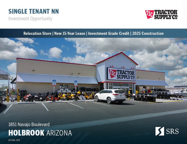
This Property Is For Sale
NEARBY LISTINGS FOR SALE OR LEASE
Property Detail
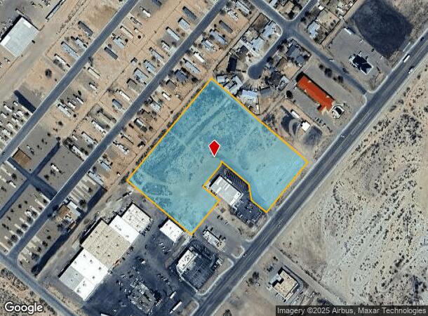
1637 N Navajo Blvd
Show Low, AZ
Buzzard Gulch
109-38-002D
SECTION 31,T18N,R21E:NELY 1/2COMMERCIAL AREABUZZARD GULCH DEV AKA: BEG NE COR SEC 31;TH N89DG58'W 164';TH S39DG44'W 1675'TPOB; THN50DG16'W 520';TH S39DG44'W 606.66';TH S50DG16'E 520'; TH N39DG44'E 606.66'TPOBALSO THAT PORTION OF ABANDONED HWY R/W BEI
Commercialacreage
Navajo
X
Arizona
04017C3342F
6.53 AC
2024
Arizona Northeast & Holbrook Area
2026
Other Market Areas
960200
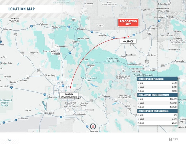
DEMOGRAPHICS near 1637 N Navajo Blvd
1 Mile
3 Mile
5 Mile
2024 Total Population
1,845
4,324
4,599
2029 Population
1,791
4,257
4,541
Pop Growth 2024-2029
(2.93%)
(1.55%)
(1.26%)
Average Age
38
38
38
2024 Total Households
604
1,480
1,576
HH Growth 2024-2029
(4.14%)
(2.36%)
(2.03%)
Median Household Inc
$56,627
$59,545
$59,649
Avg Household Size
2.80
2.70
2.70
2024 Avg HH Vehicles
2.00
2.00
2.00
Median Home Value
$158,695
$150,766
$151,719
Median Year Built
1979
1976
1976
Nearby Places
- Restaurants
- Banks
- Shops
- Fitness
- Groceries
Nearby Properties
Address
Land Use
TOTAL SIZE
Lot Size
Zoning
Address
Land Use
TOTAL SIZE
Lot Size
Zoning
115,186 SF
25.95 AC
MUNICIPAL
Address
Land Use
TOTAL SIZE
Lot Size
Zoning
37,920 SF
4.31 AC
MUNICIPAL
Address
Land Use
TOTAL SIZE
Lot Size
Zoning
79,467 SF
7.39 AC
MUNICIPAL
Address
Land Use
TOTAL SIZE
Lot Size
Zoning
32,898 SF
6.09 AC
MUNICIPAL
Address
Land Use
TOTAL SIZE
Lot Size
Zoning
25,873 SF
1.93 AC
MUNICIPAL
Address
Land Use
TOTAL SIZE
Lot Size
Zoning
210,000 SF
68.45 AC
MUNICIPAL
Address
Land Use
TOTAL SIZE
Lot Size
Zoning
31,501 SF
1.24 AC
MUNICIPAL
Address
Land Use
TOTAL SIZE
Lot Size
Zoning
30,856 SF
5.48 AC
MUNICIPAL
Address
Land Use
TOTAL SIZE
Lot Size
Zoning
24,614 SF
1.79 AC
MUNICIPAL
Address
Land Use
TOTAL SIZE
Lot Size
Zoning
26,680 SF
1.42 AC
MUNICIPAL
Address
Land Use
TOTAL SIZE
Lot Size
Zoning
21,949 SF
1.56 AC
MUNICIPAL
Address
Land Use
TOTAL SIZE
Lot Size
Zoning
20,000 SF
20.16 AC
MUNICIPAL
Address
Land Use
TOTAL SIZE
Lot Size
Zoning
32,528 SF
2 AC
MUNICIPAL
Address
Land Use
TOTAL SIZE
Lot Size
Zoning
10,513 SF
4.29 AC
MUNICIPAL
Address
Land Use
TOTAL SIZE
Lot Size
Zoning
13,330 SF
1.12 AC
MUNICIPAL
Address
Land Use
TOTAL SIZE
Lot Size
Zoning
23,549 SF
1.60 AC
MUNICIPAL
Address
Land Use
TOTAL SIZE
Lot Size
Zoning
27,298 SF
128.53 AC
Address
Land Use
TOTAL SIZE
Lot Size
Zoning
26,403 SF
4.51 AC
MUNICIPAL
Address
Land Use
TOTAL SIZE
Lot Size
Zoning
23,775 SF
1.57 AC
MUNICIPAL
Address
Land Use
TOTAL SIZE
Lot Size
Zoning
17,768 SF
2.38 AC
MUNICIPAL
Address
Land Use
TOTAL SIZE
Lot Size
Zoning
16,431 SF
1.07 AC
MUNICIPAL
Address
Land Use
TOTAL SIZE
Lot Size
Zoning
10,488 SF
0.68 AC
MUNICIPAL
Address
Land Use
TOTAL SIZE
Lot Size
Zoning
10,626 SF
1.59 AC
MUNICIPAL
Address
Land Use
TOTAL SIZE
Lot Size
Zoning
12,143 SF
2.15 AC
MUNICIPAL
Address
Land Use
TOTAL SIZE
Lot Size
Zoning
22,173 SF
1.13 AC
MUNICIPAL
Address
Land Use
TOTAL SIZE
Lot Size
Zoning
15,568 SF
0.26 AC
MUNICIPAL
Address
Land Use
TOTAL SIZE
Lot Size
Zoning
9,012 SF
0.84 AC
MUNICIPAL
Address
Land Use
TOTAL SIZE
Lot Size
Zoning
33,455 SF
3.76 AC
MUNICIPAL
Address
Land Use
TOTAL SIZE
Lot Size
Zoning
14,862 SF
0.62 AC
MUNICIPAL
The World's #1 Commercial Real Estate Marketplace
Connect with us
© 2025 CoStar Group
The information above has been obtained from sources believed reliable. While we do not doubt its accuracy we have not verified it and make no guarantee, warranty or representation about it. It is your responsibility to independently confirm its accuracy and completeness. Any projections, opinions, assumptions, or estimates used are for example only and do not represent the current or future performance of the property. The value of this transaction to you depends on tax and other factors which should be evaluated by your tax, financial, and legal advisors. You and your advisors should conduct a careful, independent investigation of the property to determine to your satisfaction the suitability of the property for your needs.