Property Record
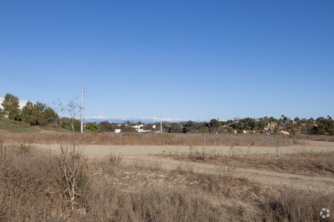
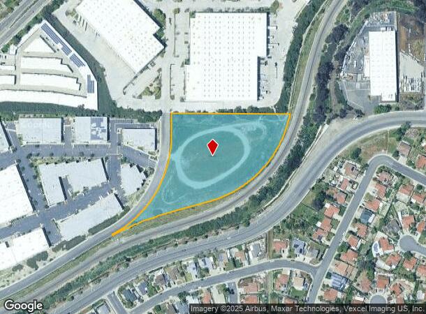
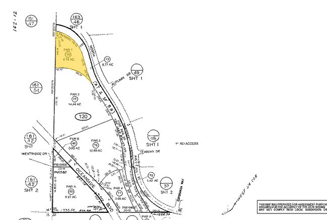
1851 Ord Way, Oceanside, CA 92056
NEARBY LISTINGS FOR SALE OR LEASE
Property Detail
1851 Ord Way
San Diego-Chula Vista-Carlsbad, CA
City Of Oceanside
162-121-01
PAR 1 TR PM19400
Industrialacreage
San Diego
X
California
06073C0759G
4.74 AC
2024
Oceanside
2025
San Diego
019403
DEMOGRAPHICS near 1851 Ord Way
1 mile
3 mile
5 mile
2024 Total Population
17,918
146,665
279,958
2029 Population
17,691
145,257
277,244
Pop Growth 2024-2029
(1.27%)
(0.96%)
(0.97%)
Average Age
40
39
40
2024 Total Households
6,126
47,822
95,378
HH Growth 2024-2029
(1.50%)
(1.18%)
(1.17%)
Median Household Inc
$94,606
$89,169
$90,780
Avg Household Size
2.80
2.90
2.80
2024 Avg HH Vehicles
2.00
2.00
2.00
Median Home Value
$649,345
$653,912
$698,218
Median Year Built
1982
1983
1983
Nearby Places
Map Layers
Map Styles
 Street
 Aerial
Transit
 Traffic
 Biking
Places
Listings with unknown addresses are not visible on the map
- Restaurants
- Banks
- Shops
- Fitness
- Groceries
PUBLIC TRANSPORTATION
COMMUTER RAIL
Oceanside Transit Center (Metrolink Inland Empire-Orange County Line - Metrolink Trains, Metrolink Orange County Line - Metrolink Trains, Orange County Line - Metrolink Trains)
Drive
Walk
Distance
Oceanside Transit Center (Metrolink Inland Empire-Orange County Line - Metrolink Trains, Metrolink Orange County Line - Metrolink Trains, Orange County Line - Metrolink Trains)
16 min
7.7 mi
Carlsbad Village (Coaster - San Diego North County Transit District (Coaster/Sprinter/Breeze))
Drive
Walk
Distance
Carlsbad Village (Coaster - San Diego North County Transit District (Coaster/Sprinter/Breeze))
14 min
7.8 mi
Freight Ports
Port of San Diego
Drive
Walk
Distance
Port of San Diego
57 min
44.3 mi
Nearby Properties
Address
Land Use
TOTAL SIZE
Lot Size
Zoning
Address
Land Use
TOTAL SIZE
Lot Size
Zoning
20.96 AC
SP-1-84 (I
Address
Land Use
TOTAL SIZE
Lot Size
Zoning
20.10 AC
M-U
Address
Land Use
TOTAL SIZE
Lot Size
Zoning
15.74 AC
SP-1-84 (I
Address
Land Use
TOTAL SIZE
Lot Size
Zoning
10.39 AC
M-U (40)
Address
Land Use
TOTAL SIZE
Lot Size
Zoning
18.89 AC
PD-1 (Res)
Address
Land Use
TOTAL SIZE
Lot Size
Zoning
15.25 AC
P-C
Address
Land Use
TOTAL SIZE
Lot Size
Zoning
11.17 AC
M-U
Address
Land Use
TOTAL SIZE
Lot Size
Zoning
31.94 AC
RM-B
Address
Land Use
TOTAL SIZE
Lot Size
Zoning
38.61 AC
PD-1 (IL)
Address
Land Use
TOTAL SIZE
Lot Size
Zoning
21.44 AC
C-1
Address
Land Use
TOTAL SIZE
Lot Size
Zoning
1.23 AC
SPI
Address
Land Use
TOTAL SIZE
Lot Size
Zoning
12 AC
SP-1-09
Address
Land Use
TOTAL SIZE
Lot Size
Zoning
7.97 AC
SPI-DV
Address
Land Use
TOTAL SIZE
Lot Size
Zoning
7.57 AC
R-M
Address
Land Use
TOTAL SIZE
Lot Size
Zoning
5.10 AC
R-M
Address
Land Use
TOTAL SIZE
Lot Size
Zoning
96,240 SF
22.25 AC
PD-2
Address
Land Use
TOTAL SIZE
Lot Size
Zoning
6.87 AC
CN-SP-EQ
Address
Land Use
TOTAL SIZE
Lot Size
Zoning
5.24 AC
SP-1-09
Address
Land Use
TOTAL SIZE
Lot Size
Zoning
9.48 AC
R-M
Address
Land Use
TOTAL SIZE
Lot Size
Zoning
14.08 AC
RH
Address
Land Use
TOTAL SIZE
Lot Size
Zoning
10.38 AC
R-M
Address
Land Use
TOTAL SIZE
Lot Size
Zoning
6.55 AC
R-M
Address
Land Use
TOTAL SIZE
Lot Size
Zoning
15.02 AC
SP-1-84 (I
Address
Land Use
TOTAL SIZE
Lot Size
Zoning
25.16 AC
SP-1-84 (I
Address
Land Use
TOTAL SIZE
Lot Size
Zoning
87,472 SF
4.96 AC
RM-A
Address
Land Use
TOTAL SIZE
Lot Size
Zoning
65,156 SF
2.52 AC
PD-1 (IL)
Address
Land Use
TOTAL SIZE
Lot Size
Zoning
11.60 AC
RM-C
Address
Land Use
TOTAL SIZE
Lot Size
Zoning
78,489 SF
2.67 AC
PD-1 (IL)
Address
Land Use
TOTAL SIZE
Lot Size
Zoning
83,995 SF
5.88 AC
PD-1 (IL)
Address
Land Use
TOTAL SIZE
Lot Size
Zoning
15.81 AC
SP-1-84 (I
The World's #1 Commercial Real Estate Marketplace
Connect with us
© 2026 CoStar Group
The information above has been obtained from sources believed reliable. While we do not doubt its accuracy we have not verified it and make no guarantee, warranty or representation about it. It is your responsibility to independently confirm its accuracy and completeness. Any projections, opinions, assumptions, or estimates used are for example only and do not represent the current or future performance of the property. The value of this transaction to you depends on tax and other factors which should be evaluated by your tax, financial, and legal advisors. You and your advisors should conduct a careful, independent investigation of the property to determine to your satisfaction the suitability of the property for your needs.