Property Record
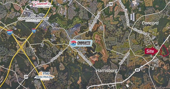
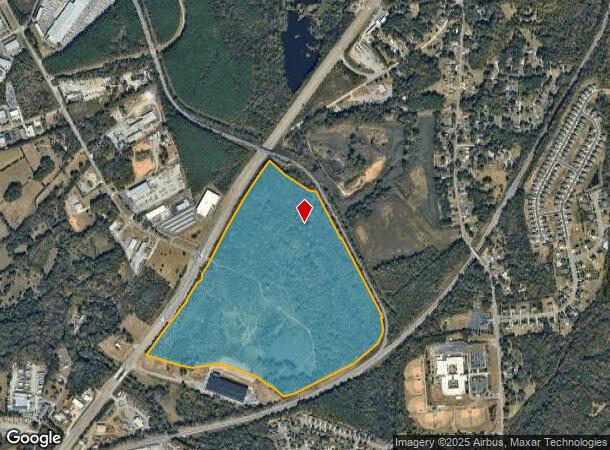
1852 Highway 49 S, Concord, NC 28027
This Property Is For Sale
NEARBY LISTINGS FOR SALE OR LEASE
Property Detail
1852 Highway 49 S
Charlotte-Concord-Gastonia, NC-SC
Stough Rd
5528-14-2445-0000
S/S HWY 49 - RECOMB MORRISON RIDGE 57-34
Industrialgeneral
Cabarrus
AE
North Carolina
3710552800K
112.91 AC
2025
Cabarrus County
2025
Charlotte
042503
DEMOGRAPHICS near 1852 Highway 49 S
1 Mile
3 Mile
5 Mile
2024 Total Population
1,686
39,613
93,165
2029 Population
1,906
44,505
104,818
Pop Growth 2024-2029
+ 13.05%
+ 12.35%
+ 12.51%
Average Age
36
37
38
2024 Total Households
537
13,567
32,477
HH Growth 2024-2029
+ 11.55%
+ 10.92%
+ 11.12%
Median Household Inc
$117,187
$89,897
$86,108
Avg Household Size
3.10
2.80
2.80
2024 Avg HH Vehicles
2.00
2.00
2.00
Median Home Value
$338,766
$274,635
$280,549
Median Year Built
2010
2000
1996
Nearby Places
- Restaurants
- Banks
- Shops
- Fitness
- Groceries
PUBLIC TRANSPORTATION
AIRPORT
Concord-Padgett Regional
DRIVE
WALK
Distance
Concord-Padgett Regional
23 min
13.4 mi
Charlotte/Douglas International
DRIVE
WALK
Distance
Charlotte/Douglas International
43 min
27.4 mi
Freight Ports
Port of Wilmington
DRIVE
WALK
Distance
Port of Wilmington
253 min
195.9 mi
Nearby Properties
Address
Land Use
TOTAL SIZE
Lot Size
Zoning
Address
Land Use
TOTAL SIZE
Lot Size
Zoning
495.38 AC
I-2
Address
Land Use
TOTAL SIZE
Lot Size
Zoning
196,893 SF
43.82 AC
MDR
Address
Land Use
TOTAL SIZE
Lot Size
Zoning
163,494 SF
89.85 AC
I-2
Address
Land Use
TOTAL SIZE
Lot Size
Zoning
6,539 SF
173.17 AC
LI
Address
Land Use
TOTAL SIZE
Lot Size
Zoning
21,714 SF
15.02 AC
RC
Address
Land Use
TOTAL SIZE
Lot Size
Zoning
199,363 SF
53.36 AC
I-1
Address
Land Use
TOTAL SIZE
Lot Size
Zoning
35,268 SF
54 AC
PUD
Address
Land Use
TOTAL SIZE
Lot Size
Zoning
152,554 SF
29.94 AC
O-I
Address
Land Use
TOTAL SIZE
Lot Size
Zoning
160,412 SF
39.97 AC
O-I
Address
Land Use
TOTAL SIZE
Lot Size
Zoning
360,400 SF
20.32 AC
EC
Address
Land Use
TOTAL SIZE
Lot Size
Zoning
116,471 SF
24.39 AC
PUD
Address
Land Use
TOTAL SIZE
Lot Size
Zoning
125,245 SF
21.47 AC
O-I
Address
Land Use
TOTAL SIZE
Lot Size
Zoning
304,000 SF
17.30 AC
EC
Address
Land Use
TOTAL SIZE
Lot Size
Zoning
160,357 SF
26.85 AC
O-I
Address
Land Use
TOTAL SIZE
Lot Size
Zoning
8,640 SF
15.51 AC
RC
Address
Land Use
TOTAL SIZE
Lot Size
Zoning
126,214 SF
93.87 AC
O-I
Address
Land Use
TOTAL SIZE
Lot Size
Zoning
12,486 SF
232.04 AC
O-I
Address
Land Use
TOTAL SIZE
Lot Size
Zoning
174,732 SF
29.05 AC
LI
Address
Land Use
TOTAL SIZE
Lot Size
Zoning
7,584 SF
12.63 AC
RC
Address
Land Use
TOTAL SIZE
Lot Size
Zoning
8,656 SF
10.01 AC
RC
Address
Land Use
TOTAL SIZE
Lot Size
Zoning
54,503 SF
9.32 AC
EC
Address
Land Use
TOTAL SIZE
Lot Size
Zoning
12,150 SF
7.23 AC
GI
Address
Land Use
TOTAL SIZE
Lot Size
Zoning
220,121 SF
10.99 AC
I-2
Address
Land Use
TOTAL SIZE
Lot Size
Zoning
21,152 SF
6.03 AC
MDR
Address
Land Use
TOTAL SIZE
Lot Size
Zoning
38,274 SF
15.29 AC
PUD
Address
Land Use
TOTAL SIZE
Lot Size
Zoning
29,725 SF
100.58 AC
I-1
Address
Land Use
TOTAL SIZE
Lot Size
Zoning
86,460 SF
13.73 AC
I-2
Address
Land Use
TOTAL SIZE
Lot Size
Zoning
39,250 SF
74.14 AC
I-1
Address
Land Use
TOTAL SIZE
Lot Size
Zoning
71,918 SF
51.27 AC
O-I
Address
Land Use
TOTAL SIZE
Lot Size
Zoning
33,458 SF
8.10 AC
CUO-I
The World's #1 Commercial Real Estate Marketplace
Connect with us
© 2025 CoStar Group
The information above has been obtained from sources believed reliable. While we do not doubt its accuracy we have not verified it and make no guarantee, warranty or representation about it. It is your responsibility to independently confirm its accuracy and completeness. Any projections, opinions, assumptions, or estimates used are for example only and do not represent the current or future performance of the property. The value of this transaction to you depends on tax and other factors which should be evaluated by your tax, financial, and legal advisors. You and your advisors should conduct a careful, independent investigation of the property to determine to your satisfaction the suitability of the property for your needs.